Category:Muckle Flugga Lighthouse
| Object location | | View all coordinates using: OpenStreetMap |
|---|
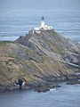
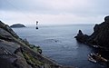
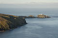
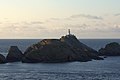
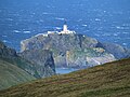
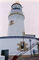
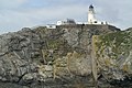
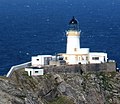
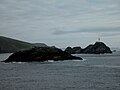
English: Muckle Flugga Lighthouse on the island north of Unst marks the northernmost tip of the British Isles.
lighthouse built 1858 in Shetland Islands .jpg) .jpg) | |||||
| Upload media | |||||
| Instance of | |||||
|---|---|---|---|---|---|
| Made from material | |||||
| Location |
| ||||
| Operator | |||||
| Heritage designation |
| ||||
| Service entry |
| ||||
| Significant event |
| ||||
| Height |
| ||||
 | |||||
Subcategories
This category has only the following subcategory.
M
Media in category "Muckle Flugga Lighthouse"
The following 69 files are in this category, out of 69 total.
-
 Nort Unst.jpg 988 × 862; 471 KB
-
-

-
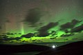 Aurora borealis over Muckle Flugga (geograph 3178463).jpg 1,024 × 683; 197 KB
-
 Baa Skerries.jpg 640 × 420; 205 KB
-
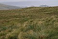
 Burrafirth links - geograph.org.uk - 945936.jpg 640 × 426; 67 KB
-
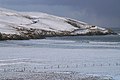 Burrafirth links in the snow - geograph.org.uk - 1055060.jpg 640 × 426; 86 KB
-
 Distant Muckle Flugga from Gloup - geograph.org.uk - 2697009.jpg 1,773 × 1,000; 1.07 MB
-
 Djubi Dale - geograph.org.uk - 382156.jpg 640 × 419; 70 KB
-
 Djubi Dale, Saxa Vord, in snow - geograph.org.uk - 1055382.jpg 640 × 418; 92 KB
-

-
 Gannet (Morus bassana), passing Muckle Flugga - geograph.org.uk - 5797061.jpg 1,600 × 1,068; 265 KB
-
 Herma Ness, lighthouse close-up - geograph.org.uk - 3558546.jpg 640 × 481; 40 KB
-
 Herma Ness, Muckle Flugga lighthouse - geograph.org.uk - 2539106.jpg 480 × 640; 72 KB
-

-
 Lee of Saxavord - geograph.org.uk - 878264.jpg 640 × 334; 42 KB
-
 Lighthouse Muckle Flugga.1.jpg 2,560 × 1,920; 1.35 MB
-
 Longa Stacks and Muckle Flugga - geograph.org.uk - 933435.jpg 640 × 426; 64 KB
-

-

-
 Lower slopes of Hermaness Hill, Unst.jpg 640 × 479; 45 KB
-
 Moonrise over Burra Firth - geograph.org.uk - 637029.jpg 640 × 426; 55 KB
-
 Most Northerly Lighthouse (51331622205).jpg 7,828 × 5,176; 33.69 MB
-
 Muckle Flugga - geograph.org.uk - 1971637.jpg 800 × 517; 295 KB
-
 Muckle Flugga - geograph.org.uk - 1971646.jpg 350 × 464; 30 KB
-
 Muckle Flugga - geograph.org.uk - 342315.jpg 640 × 402; 37 KB
-
 Muckle Flugga - geograph.org.uk - 84351.jpg 640 × 440; 61 KB
-
 Muckle Flugga from Saxa Vord - geograph.org.uk - 1616163.jpg 640 × 427; 39 KB
-
 Muckle Flugga from Taing of Loosswick, Hermaness - geograph.org.uk - 3530686.jpg 1,024 × 682; 101 KB
-
 Muckle Flugga Lighthouse (12925488683).jpg 5,184 × 3,456; 17.39 MB
-
 Muckle Flugga Lighthouse (25227855950).jpg 5,146 × 3,431; 9.98 MB
-
 Muckle Flugga Lighthouse (8204784808).jpg 2,560 × 1,691; 1.88 MB
-
 Muckle Flugga lighthouse - geograph.org.uk - 2695542.jpg 1,823 × 1,000; 1.17 MB
-
 Muckle Flugga lighthouse - geograph.org.uk - 3977020.jpg 2,048 × 1,536; 500 KB
-
 Muckle Flugga lighthouse - geograph.org.uk - 4999397.jpg 2,547 × 1,872; 823 KB
-
 Muckle Flugga lighthouse - geograph.org.uk - 5790931.jpg 3,648 × 2,736; 3.07 MB
-
 Muckle Flugga Lighthouse - geograph.org.uk - 5922715.jpg 800 × 601; 638 KB
-
 Muckle Flugga lighthouse 2.jpg 417 × 640; 38 KB
-
 Muckle Flugga lighthouse and associated skerries - geograph.org.uk - 3459893.jpg 3,888 × 2,592; 1.15 MB
-
 Muckle Flugga lighthouse at dusk - geograph.org.uk - 2468854.jpg 800 × 545; 75 KB
-

-

-
 Muckle Flugga lighthouse at sunset - geograph.org.uk - 6191052.jpg 1,600 × 1,066; 419 KB
-
 Muckle Flugga Lighthouse from Sothers Field - geograph.org.uk - 5224502.jpg 1,024 × 682; 94 KB
-

-

-
 Muckle Flugga lighthouse.jpg 640 × 426; 68 KB
-
 Muckle Flugga Lighthouse.jpg 1,024 × 681; 353 KB
-
 Muckle Flugga, Shetland.jpg 640 × 480; 107 KB
-
 Muckle Flugga.jpg 585 × 425; 63 KB
-
 Muckle Fulga Sunny (cropped).jpg 1,085 × 937; 238 KB
-
 Muckle Fulga Sunny.jpg 1,591 × 2,125; 780 KB
-
 MuckleFluggaLighthouse-pjt.jpg 6,192 × 3,483; 8.31 MB
-
 North end of Hermaness - geograph.org.uk - 3977026.jpg 2,048 × 1,536; 1.5 MB
-

-
 Out Stack.2.jpg 2,560 × 1,920; 1.25 MB
-

-
 Shore Station, Burrafirth - geograph.org.uk - 1616138.jpg 640 × 426; 76 KB
-
 Slopes of Saxa - geograph.org.uk - 657099.jpg 640 × 426; 70 KB
-
 Szetlandy - panoramio.jpg 2,436 × 1,419; 2.18 MB
-
 The mouth of Burra Firth - geograph.org.uk - 342668.jpg 640 × 382; 33 KB
-
 The Muckle Flugga supply boat at Muckle Flugga - geograph.org.uk - 2431945.jpg 1,184 × 806; 254 KB
-
 The Noup, Saxa Vord - geograph.org.uk - 524442.jpg 640 × 426; 44 KB
-
 The Shore Station from the sea - geograph.org.uk - 5522468.jpg 1,024 × 683; 110 KB
-
 The top of the UK - geograph.org.uk - 694614.jpg 640 × 480; 33 KB
-
 Toolie - geograph.org.uk - 206956.jpg 640 × 413; 199 KB
-
 View from the north end of Hermaness - geograph.org.uk - 941054.jpg 640 × 426; 62 KB
-

-
 West Slope of Hermaness Hill - geograph.org.uk - 206923.jpg 640 × 397; 201 KB


,_passing_Muckle_Flugga_-_geograph.org.uk_-_5797061.jpg)


.jpg)


.jpg)
.jpg)
.jpg)


