Category:NGA maps and charts
This category contains maps and charts issued by the National Geospatial-Intelligence Agency (NGA) and the former National Imagery and Mapping Agency (NIMA).
Media in category "NGA maps and charts"
The following 27 files are in this category, out of 27 total.
-
 Bien Hoa, Edition 2-TPC, Series L909, National Imagery and Mapping Agency, 1968.jpg 5,191 × 7,974; 11.17 MB
-
 Can Tho, Edition 1-TPC (29 ETB), Series L909, National Imagery and Mapping Agency, 1970.jpg 8,269 × 6,378; 15.4 MB
-
 Enroute sailing directions SDLimits.jpg 1,193 × 900; 270 KB
-
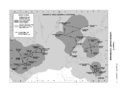
 Former saudi-kuwaiti neutral zone.jpg 300 × 300; 100 KB
-
 Hai Phong, Edition 1, Series L909, National Imagery and Mapping Agency, 1968.jpg 8,715 × 6,797; 15.22 MB
-
 Hon Gay, Edition 1, Series L909, National Imagery and Mapping Agency, 1968.jpg 5,783 × 4,338; 6.7 MB
-

-
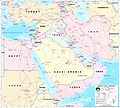 Middle east graphic 2003.jpg 2,973 × 2,685; 3.91 MB
-
 Mustique Island NGA chart.png 1,600 × 817; 1.17 MB
-
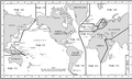
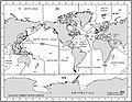
 Mv-world.jpg 5,700 × 4,200; 4.77 MB
-
 My Tho, Edition 2-DMATC, Series L909, Defense Mapping Agency, 1971.jpg 7,726 × 5,289; 11.85 MB
-
 NGA-Atlantic Loran.png 2,044 × 1,504; 241 KB
-
 NGA-List of lights 5.png 1,476 × 881; 114 KB
-
 NGA-List of lights.png 922 × 648; 119 KB
-
 NGA-Pacific Loran.png 2,044 × 1,504; 333 KB
-
 Nha Trang, Edition 3, Series L909, National Imagery and Mapping Agency, 1968.jpg 3,820 × 5,235; 6.4 MB
-
 NOS Chart Catalog-Bahamas Bermuda-List.jpg 4,526 × 3,491; 1.12 MB
-
 SAILING DIRECTIONS-ENROUTE-Caribbean Sea Vol 1-1Cover.jpg 4,537 × 5,856; 579 KB
-
 SAILING DIRECTIONS-ENROUTE-Caribbean Sea Vol 1-2Index.jpg 4,563 × 5,859; 1,000 KB
-
 SAILING DIRECTIONS-ENROUTE-Caribbean Sea Vol 1-3Sectors.jpg 5,848 × 4,541; 1.58 MB
-
 SDLIMITS.jpg 1,200 × 927; 165 KB
-
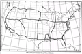 Transcontinental Traverse map from Geodesy for the Layman.png 933 × 615; 206 KB
-
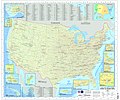 U.S. Military Installations Map.jpg 16,500 × 13,800; 52.36 MB
-
 U.S. Unified Command Plan Map 2008-12-23.pdf 1,650 × 1,275; 335 KB
-
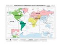
 U.S. Unified Command Plan Map 2008-12-23.png 1,600 × 1,236; 1.4 MB
-
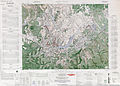 US Army Map Da Lat 1963.jpg 6,539 × 4,707; 12.12 MB
-
 Vinh and Ben Thuy, Edition 3-TPC, Series L909, National Imagery and Mapping Agency, 1970.jpg 5,238 × 4,042; 4.95 MB

,_Series_L909,_National_Imagery_and_Mapping_Agency,_1970.jpg)


,_Edition_2-TPC,_Series_L909,_National_Imagery_and_Mapping_Agency,_196-.jpg)


