Category:Nab Tower
| Object location | | View all coordinates using: OpenStreetMap |
|---|
lighthouse east of Isle of Wight, UK  | |||||
| Upload media | |||||
| Instance of |
| ||||
|---|---|---|---|---|---|
| Location | Nab Rock | ||||
| Located in or next to body of water | |||||
| Operator | |||||
| Service entry |
| ||||
| Inception |
| ||||
| Significant event |
| ||||
| Height |
| ||||
| Replaces |
| ||||
 | |||||
English: Nab Tower
Media in category "Nab Tower"
The following 10 files are in this category, out of 10 total.
-
 Admiralty Chart No 2050 Eastern approaches to the Solent, Published 1967.jpg 10,306 × 11,918; 32.08 MB
-
 East Solent, Nab Tower - geograph.org.uk - 5422165.jpg 640 × 481; 338 KB
-
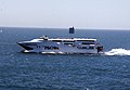 Fast ferry near Nab tower - geograph.org.uk - 375102.jpg 639 × 444; 79 KB
-
 Image of the Nab Tower after extensive repairs and alterations in 2012..JPG 4,000 × 2,664; 1.12 MB
-
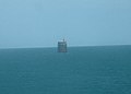
 Nab Tower lighthouse, east of Culver Cliff - geograph.org.uk - 2612258.jpg 1,024 × 768; 75 KB
-
 Nab Tower, The Solent - geograph.org.uk - 5051523.jpg 640 × 480; 342 KB
-
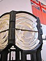 Optics (4865745080).jpg 2,736 × 3,648; 4.01 MB
-
 The Nab Tower - geograph.org.uk - 5051526.jpg 640 × 480; 343 KB
-
 The Nab Tower - lighthouse - geograph.org.uk - 88464.jpg 640 × 457; 42 KB
-
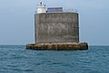 The Nab Tower as it is in2014.JPG 4,000 × 2,664; 1.34 MB


.jpg)


