Category:National Cycle Network route 141

Cycle route between Wylam and Derwent Haugh along the south bank of the River Tyne    Map of Route 141 from OSM | |||||
| Upload media | |||||
| Instance of | |||||
|---|---|---|---|---|---|
| Part of | |||||
| Location | Gateshead, Tyne and Wear, North East England, England | ||||
| Connects with | |||||
| Length |
| ||||
| Highest point |
| ||||
| official website | |||||
| |||||
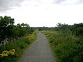
NCN route 141 runs along the South Bank of the River Tyne in Gateshead, from Wylam to Blaydon. It forms the western end of the Keelmans Way cycle route.
Media in category "National Cycle Network route 141"
The following 3 files are in this category, out of 3 total.
-
 Keelmans way - geograph.org.uk - 515129.jpg 640 × 480; 78 KB
-
 NCN Route 141.png 1,846 × 700; 1.47 MB
-
 NCN Route Sign 141.svg 512 × 212; 6 KB