Category:Nederlands Hervormde Kerk, Nieuw-Helvoet
| Object location | | View all coordinates using: OpenStreetMap |
|---|
protestant church in Nieuw-Helvoet, Netherlands .jpg) | |||||
| Upload media | |||||
| Instance of | |||||
|---|---|---|---|---|---|
| Location | Nieuw-Helvoet, Hellevoetsluis, Voorne aan Zee, South Holland, Netherlands | ||||
| Street address |
| ||||
| Located on street |
| ||||
| Heritage designation |
| ||||
| Religion or worldview | |||||
 | |||||
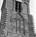
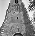
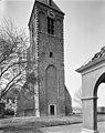
Nederlands: Corneliuskerk - anno 16e eeuw - in gebruik als cultureel centrum
|
This is a category about rijksmonument number 21440
|
| Address |
|
Media in category "Nederlands Hervormde Kerk, Nieuw-Helvoet"
The following 71 files are in this category, out of 71 total.
-
 Exterieur DICHTGEMETSELDE INGANG - Nieuw-Helvoet - 20300185 - RCE.jpg 1,195 × 1,200; 508 KB
-
 Exterieur NOORDOOST GEVEL - Nieuw-Helvoet - 20300186 - RCE.jpg 1,200 × 962; 336 KB
-

-
 Exterieur TOREN, WESTGEVEL - Nieuw-Helvoet - 20300183 - RCE.jpg 955 × 1,200; 280 KB
-
 Exterieur west-gevel - Nieuw-Helvoet - 20165036 - RCE.jpg 1,200 × 950; 363 KB
-
 Exterieur zuid-oost zijde - Nieuw-Helvoet - 20165034 - RCE.jpg 1,200 × 951; 214 KB
-
 Exterieur zuid-oost zijde - Nieuw-Helvoet - 20165035 - RCE.jpg 1,200 × 958; 266 KB
-
 Exterieur ZUIDER TRANSEPT - Nieuw-Helvoet - 20300187 - RCE.jpg 955 × 1,200; 292 KB
-
 Hellevoetsluis - Nieuw Helvoet - Noordwijk - Ringweg - Kerk toren.JPG 1,536 × 2,048; 1.57 MB
-
 Hervormde Kerk, Nieuw-Helvoet (01).jpg 1,739 × 1,273; 719 KB
-
 Hervormde Kerk, Nieuw-Helvoet (02).jpg 2,048 × 1,536; 1.55 MB
-
 Hervormde Kerk, Nieuw-Helvoet (03).jpg 1,641 × 1,289; 661 KB
-
 Hervormde Kerk, Nieuw-Helvoet (04).jpg 1,536 × 2,048; 1.59 MB
-
 Hervormde Kerk, Nieuw-Helvoet (05).jpg 1,536 × 2,048; 1.66 MB
-
 Hervormde Kerk, Nieuw-Helvoet (06).jpg 1,297 × 1,990; 983 KB
-
 Hervormde Kerk, Nieuw-Helvoet (06a).jpg 935 × 1,425; 498 KB
-
 Hervormde Kerk, Nieuw-Helvoet (07).jpg 1,185 × 1,919; 765 KB
-
 Hervormde Kerk, Nieuw-Helvoet (08).jpg 1,536 × 2,048; 743 KB
-
 Hervormde Kerk, Nieuw-Helvoet (09).jpg 1,747 × 1,259; 563 KB
-
 Hervormde Kerk, Nieuw-Helvoet (10).jpg 1,773 × 1,528; 890 KB
-
 Hervormde Kerk, Nieuw-Helvoet (11).jpg 2,048 × 1,536; 1.52 MB
-
 Hervormde Kerk, Nieuw-Helvoet (12).jpg 2,048 × 1,536; 395 KB
-
 Hervormde Kerk, Nieuw-Helvoet (13).jpg 2,048 × 1,536; 338 KB
-
 Interieur naar het oosten (orgel) - Nieuw-Helvoet - 20165029 - RCE.jpg 1,200 × 954; 185 KB
-
 Interieur naar het oosten - Nieuw-Helvoet - 20165026 - RCE.jpg 968 × 1,200; 215 KB
-
 Interieur naar het oosten - Nieuw-Helvoet - 20165030 - RCE.jpg 1,200 × 952; 156 KB
-
 Interieur naar het westen - Nieuw-Helvoet - 20165025 - RCE.jpg 971 × 1,200; 204 KB
-
 Interieur naar het westen - Nieuw-Helvoet - 20165033 - RCE.jpg 1,200 × 955; 146 KB
-
 Interieur noord zijbeuk - Nieuw-Helvoet - 20165032 - RCE.jpg 1,200 × 958; 159 KB
-
 Interieur toren - Nieuw-Helvoet - 20165053 - RCE.jpg 1,186 × 1,200; 289 KB
-
 Interieur toren - Nieuw-Helvoet - 20165054 - RCE.jpg 1,197 × 1,200; 323 KB
-
 Interieur toren - Nieuw-Helvoet - 20165055 - RCE.jpg 1,195 × 1,200; 351 KB
-
 Interieur toren, klok - Nieuw-Helvoet - 20165056 - RCE.jpg 1,195 × 1,200; 362 KB
-
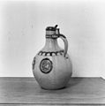 INTERIEUR, AVONDMAALSKRUIK - Nieuw-Helvoet - 20267199 - RCE.jpg 1,190 × 1,200; 218 KB
-
 INTERIEUR, DOOPBEKKEN - Nieuw-Helvoet - 20267202 - RCE.jpg 1,195 × 1,200; 233 KB
-
 INTERIEUR, KAARSENKROON - Nieuw-Helvoet - 20267201 - RCE.jpg 1,197 × 1,200; 207 KB
-
 INTERIEUR, LEZENAAR VAN DE PREEKSTOEL - Nieuw-Helvoet - 20300190 - RCE.jpg 1,188 × 1,200; 307 KB
-
 INTERIEUR, OVERZICHT NAAR HET WESTEN - Nieuw-Helvoet - 20300188 - RCE.jpg 960 × 1,200; 185 KB
-

-
 INTERIEUR, PREEKSTOEL - Nieuw-Helvoet - 20300189 - RCE.jpg 960 × 1,200; 181 KB
-
 INTERIEUR, PREEKSTOEL, LEZENAAR - Nieuw-Helvoet - 20267200 - RCE.jpg 1,195 × 1,200; 333 KB
-
 Inwendig naar het oosten en naar het westen - Nieuw-Helvoet - 20165023 - RCE.jpg 849 × 1,200; 167 KB
-
 Inwendig naar het oosten en naar het westen - Nieuw-Helvoet - 20165024 - RCE.jpg 881 × 1,200; 178 KB
-
 Kerk vanuit het noord-oosten - Nieuw-Helvoet - 20165018 - RCE.jpg 879 × 1,200; 202 KB
-
 Kerk vanuit het noord-oosten - Nieuw-Helvoet - 20165021 - RCE.jpg 855 × 1,200; 163 KB
-
 Kerk vanuit het noord-westen - Nieuw-Helvoet - 20165020 - RCE.jpg 852 × 1,200; 269 KB
-
 Kerk vanuit het noorden - Nieuw-Helvoet - 20165022 - RCE.jpg 851 × 1,200; 227 KB
-
 Kerk vanuit het oosten - Nieuw-Helvoet - 20165019 - RCE.jpg 895 × 1,200; 142 KB
-
 Kerk vanuit het westen - Nieuw-Helvoet - 20165017 - RCE.jpg 1,200 × 894; 295 KB
-
 Overzicht - Nieuw-Helvoet - 20165038 - RCE.jpg 1,200 × 956; 252 KB
-
 Overzicht kerk en losstaande toren - Nieuw-Helvoet - 20165027 - RCE.jpg 1,200 × 894; 243 KB
-
 Overzicht toren losstaand van de kerk - Nieuw-Helvoet - 20377284 - RCE.jpg 1,200 × 956; 342 KB
-
 Preekstoel - Nieuw-Helvoet - 20165031 - RCE.jpg 951 × 1,200; 171 KB
-
 Toren naar het zuid-oosten - Nieuw-Helvoet - 20165015 - RCE.jpg 881 × 1,200; 244 KB
-
 Toren vanuit het zuid-westen - Nieuw-Helvoet - 20165014 - RCE.jpg 889 × 1,200; 183 KB
-
 Toren, detail - Nieuw-Helvoet - 20165050 - RCE.jpg 1,190 × 1,200; 467 KB
-
 Toren, detail - Nieuw-Helvoet - 20165051 - RCE.jpg 1,188 × 1,200; 502 KB
-
 Toren, detail westgevel - Nieuw-Helvoet - 20165049 - RCE.jpg 1,195 × 1,200; 405 KB
-
 Toren, gedeelte westgevel - Nieuw-Helvoet - 20165043 - RCE.jpg 1,188 × 1,200; 257 KB
-
 Toren, gedeelte westgevel - Nieuw-Helvoet - 20165044 - RCE.jpg 1,188 × 1,200; 307 KB
-
 Toren, gedeelte westgevel - Nieuw-Helvoet - 20165045 - RCE.jpg 1,190 × 1,200; 338 KB
-
 Toren, gedeelte westgevel - Nieuw-Helvoet - 20165046 - RCE.jpg 1,192 × 1,200; 488 KB
-
 Toren, gedeelte westgevel - Nieuw-Helvoet - 20165047 - RCE.jpg 1,186 × 1,200; 488 KB
-
 Toren, noord-west zijde - Nieuw-Helvoet - 20165041 - RCE.jpg 948 × 1,200; 296 KB
-
 Toren, noordgevel - Nieuw-Helvoet - 20165042 - RCE.jpg 960 × 1,200; 208 KB
-
 Toren, voormalige ingang - Nieuw-Helvoet - 20165052 - RCE.jpg 1,192 × 1,200; 545 KB
-
 Toren, westzijde - Nieuw-Helvoet - 20165039 - RCE.jpg 950 × 1,200; 228 KB
-
 Toren, zuid-west zijde - Nieuw-Helvoet - 20165040 - RCE.jpg 936 × 1,200; 199 KB
-
 Toren, zuidgevel - Nieuw-Helvoet - 20165048 - RCE.jpg 1,188 × 1,200; 397 KB
-
 West Toren, ingang - Nieuw-Helvoet - 20165016 - RCE.jpg 885 × 1,200; 369 KB
-
 West zijbeuk - Nieuw-Helvoet - 20165037 - RCE.jpg 1,200 × 953; 242 KB


.jpg)
.jpg)
.jpg)
.jpg)
.jpg)
.jpg)
.jpg)
.jpg)
.jpg)
.jpg)
.jpg)
.jpg)
.jpg)
_-_Nieuw-Helvoet_-_20165029_-_RCE.jpg)


