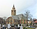
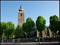
Category:Nederlands Hervormde Kerk, Rijnsburg
| Object location | | View all coordinates using: OpenStreetMap |
|---|
protestant church building in Katwijk, Netherlands _(2).jpg) | |||||
| Upload media | |||||
| Instance of | |||||
|---|---|---|---|---|---|
| Named after | |||||
| Dedicated to | |||||
| Location | Rijnsburg, Katwijk, South Holland, Netherlands | ||||
| Street address |
| ||||
| Architectural style | |||||
| Heritage designation |
| ||||
| Religion or worldview | |||||
| official website | |||||
 | |||||
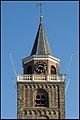
Kerk:
|
This is a category about rijksmonument number 33009
|
Toren:
|
This is a category about rijksmonument number 33010
|
| Address |
|
Subcategories
This category has the following 2 subcategories, out of 2 total.
F
- Floris V (Rijnsburg) (8 F)
Media in category "Nederlands Hervormde Kerk, Rijnsburg"
The following 60 files are in this category, out of 60 total.
-
 Achtergevels - Rijnsburg - 20187044 - RCE.jpg 1,188 × 1,200; 330 KB
-
 Gevelsteen Toren - Rijnsburg - 20186964 - RCE.jpg 864 × 1,200; 359 KB
-
 Interieur, grafzerk in het middenschip - Rijnsburg - 226022 - RCE.jpg 3,054 × 3,054; 3.34 MB
-

-
 Kerkhof muurwerk - Rijnsburg - 20186978 - RCE.jpg 1,200 × 814; 381 KB
-
 Laurentiuskerk (Rijnsburg) (1).jpg 1,717 × 1,408; 643 KB
-
 Laurentiuskerk (Rijnsburg) (2).jpg 1,684 × 1,318; 606 KB
-
 Laurentiuskerk (Rijnsburg) (3).jpg 1,790 × 1,514; 682 KB
-
 Laurentiuskerk (Rijnsburg) (4).jpg 1,536 × 2,048; 587 KB
-
 Laurentiuskerk (Rijnsburg) (5).jpg 1,536 × 2,048; 412 KB
-
 Laurentiuskerk (Rijnsburg) (6).jpg 1,536 × 2,048; 601 KB
-
 Laurentiuskerk (Rijnsburg) (7).jpg 1,016 × 1,770; 485 KB
-
 Laurentiuskerk (Rijnsburg) (8).jpg 1,536 × 2,048; 592 KB
-
 Laurentiuskerk (Rijnsburg) (9).jpg 1,061 × 1,890; 437 KB
-
 Laurentiuskerk (Rijnsburg) (9a).jpg 2,048 × 1,536; 679 KB
-
 Laurentiuskerk church Rijnsburg 2019.jpg 3,648 × 5,472; 9.55 MB
-
 Muurschildering boven de preekstoel - Rijnsburg - 20187018 - RCE.jpg 1,192 × 1,200; 261 KB
-
 Nis in torenwand - Rijnsburg - 20186984 - RCE.jpg 1,190 × 1,200; 304 KB
-
 Nis in torenwand - Rijnsburg - 20186985 - RCE.jpg 1,186 × 1,200; 396 KB
-
 Noord-oost zijde - Rijnsburg - 20186977 - RCE.jpg 813 × 1,200; 160 KB
-
 Noord-west gevel - Rijnsburg - 20186989 - RCE.jpg 953 × 1,200; 248 KB
-
 Oostgevel - Rijnsburg - 20186991 - RCE.jpg 950 × 1,200; 250 KB
-
 Overzicht oostgevel - Rijnsburg - 20365353 - RCE.jpg 936 × 1,200; 248 KB
-
 Overzicht toren - Rijnsburg - 20186987 - RCE.jpg 948 × 1,200; 255 KB
-
 Overzicht toren - Rijnsburg - 20365352 - RCE.jpg 918 × 1,200; 164 KB
-
 Renaissancepoortje, west-gevel noord zijbeuk - Rijnsburg - 20186956 - RCE.jpg 863 × 1,200; 254 KB
-
 Rijnsburg NH Kerk Toren.jpg 2,736 × 3,648; 3.38 MB
-
 Rijnsburg NH Kerk.jpg 2,407 × 3,214; 2.88 MB
-
 Rijnsburg, kerk foto4 2009-10-25 13.57.JPG 2,592 × 3,456; 1.58 MB
-
 Rijnsburg-Grote Kerk-01.jpg 1,181 × 1,772; 1.49 MB
-
 Rijnsburg-Grote Kerk-02.jpg 1,181 × 1,772; 1.33 MB
-
 Rijnsburg-Grote Kerk-03.jpg 1,181 × 1,772; 1.33 MB
-
 Rijnsburg-Grote Kerk-04.jpg 1,772 × 979; 1.41 MB
-
 Rijnsburg-Grote Kerk-05.jpg 1,181 × 1,772; 1.3 MB
-
 Rijnsburg-Grote Kerk-06.jpg 1,276 × 958; 1.09 MB
-
 Romaans kapiteel in Toren - Rijnsburg - 20186965 - RCE.jpg 914 × 1,200; 270 KB
-
 Steen in het koor (Petronella) - Rijnsburg - 20187019 - RCE.jpg 1,188 × 1,200; 218 KB
-
 Stenen in het koor - Rijnsburg - 20186967 - RCE.jpg 1,200 × 880; 200 KB
-
 Stenen in het koor - Rijnsburg - 20186968 - RCE.jpg 1,027 × 1,200; 446 KB
-
 Toren naar het oosten - Rijnsburg - 20186955 - RCE.jpg 857 × 1,200; 208 KB
-
 Toren van Rijnsburg.JPG 1,920 × 2,560; 1.25 MB
-
 Toren vanuit het noord-westen - Rijnsburg - 20186963 - RCE.jpg 886 × 1,200; 240 KB
-
 Toren zuidzijde - Rijnsburg - 20186986 - RCE.jpg 772 × 1,200; 322 KB
-
 Toren, detail - Rijnsburg - 20186969 - RCE.jpg 959 × 1,200; 319 KB
-
 Toren, detail - Rijnsburg - 20186970 - RCE.jpg 959 × 1,200; 309 KB
-
 Toren, detail - Rijnsburg - 20186971 - RCE.jpg 959 × 1,200; 234 KB
-
 Toren, detail - Rijnsburg - 20186972 - RCE.jpg 1,200 × 959; 286 KB
-
 Toren, detail - Rijnsburg - 20186973 - RCE.jpg 959 × 1,200; 287 KB
-
 Toren, tijdens restauratie - Rijnsburg - 20186957 - RCE.jpg 1,200 × 951; 321 KB
-
 Toren, tijdens restauratie - Rijnsburg - 20186958 - RCE.jpg 1,200 × 935; 307 KB
-
 Toren, tijdens restauratie - Rijnsburg - 20186959 - RCE.jpg 941 × 1,200; 303 KB
-
 Toren, tijdens restauratie - Rijnsburg - 20186960 - RCE.jpg 942 × 1,200; 340 KB
-
 Toren, tijdens restauratie - Rijnsburg - 20186961 - RCE.jpg 955 × 1,200; 328 KB
-
 Toren, tijdens restauratie - Rijnsburg - 20186962 - RCE.jpg 979 × 1,200; 269 KB
-

-
 Westgevel toren - Rijnsburg - 20186988 - RCE.jpg 957 × 1,200; 209 KB
-
 Zicht op de kerktoren - Rijnsburg - 20186974 - RCE.jpg 894 × 1,200; 213 KB
-
 Zuid-oost zijde - Rijnsburg - 20186976 - RCE.jpg 813 × 1,200; 244 KB
-
 Zuidgevel - Rijnsburg - 20186990 - RCE.jpg 957 × 1,200; 284 KB
-
 Zuidgevel - Rijnsburg - 20186992 - RCE.jpg 1,200 × 960; 340 KB


_uit_het_schetsboek_van_Hendrik_Verhees_-_Rijnsburg_-_20186954_-_RCE.jpg)

_(1).jpg)
_(3).jpg)
_(4).jpg)
_(5).jpg)
_(6).jpg)
_(7).jpg)
_(8).jpg)
_(9).jpg)
_(9a).jpg)


_-_Rijnsburg_-_20187019_-_RCE.jpg)


