Category:Niesky, Rothenburger Straße 6
| Object location | | View all coordinates using: OpenStreetMap |
|---|
house in Niesky, Germany .jpg) | |||||
| Upload media | |||||
| Instance of | |||||
|---|---|---|---|---|---|
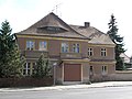
| Location | Niesky, Görlitz, Saxony, Germany | ||||
| Street address |
| ||||
| Heritage designation | |||||
 | |||||
Deutsch: Wohnhaus der 1920er Jahre mit Bäckerei; in Niesky; traditionelle zeitgenössische Formensprache; baugeschichtlich von Bedeutung
English: Residential house of the 1920s with bakery; in Niesky; traditional contemporary design language; of importance for architectural history
| (Wikidata) |
Media in category "Niesky, Rothenburger Straße 6"
The following 5 files are in this category, out of 5 total.
-
 Niesky - Rothenburger Straße 05 ies.jpg 3,888 × 2,592; 1.44 MB
-
 Niesky, Rothenburger Straße 6, Bäckerei (1).jpg 4,416 × 3,312; 3.71 MB
-
 Niesky, Rothenburger Straße 6, Bäckerei (2).jpg 4,416 × 3,312; 3.48 MB
-
 Niesky, Rothenburger Straße 6, Bäckerei (3).jpg 4,416 × 3,312; 3.74 MB
-
 Niesky, Rothenburger Straße 6, Bäckerei (4).jpg 4,416 × 3,312; 3.41 MB

.jpg)
.jpg)
.jpg)