Category:Norrmanska gården
| Object location | | View all coordinates using: OpenStreetMap |
|---|
|
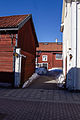
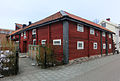
This is a category about a historic building in Sweden, number 21300000013117 in the RAÄ buildings database.
|
 | |||||
| Upload media | |||||
| Instance of | |||||
|---|---|---|---|---|---|
| Location | Sala, Sala Municipality, Västmanland County, Sweden | ||||
| Has use |
| ||||
| Heritage designation |
| ||||
 | |||||
Media in category "Norrmanska gården"
The following 15 files are in this category, out of 15 total.
-
 Norrmanska gården, Sala 01.jpg 5,031 × 3,355; 11.35 MB
-
 Norrmanska gården, Sala 02.jpg 3,238 × 4,857; 10.18 MB
-
 Norrmanska gården, Sala 03.jpg 4,927 × 3,285; 10.61 MB
-
 Norrmanska gården, Sala 04.jpg 5,034 × 3,356; 14.86 MB
-
 Norrmanska gården, Sala 05.jpg 4,858 × 3,238; 11.67 MB
-
 Norrmanska gården, Sala 06.jpg 4,799 × 3,200; 12.47 MB
-
 Norrmanska gården, Sala 07.jpg 5,030 × 3,353; 11.68 MB
-
 Norrmanska gården, Sala 08.jpg 4,695 × 3,130; 8.99 MB
-
 Norrmanska gården, Sala 09.jpg 4,152 × 2,768; 7.39 MB
-
 Norrmanska gården, Sala 10.jpg 4,975 × 3,316; 11.81 MB
-
 Norrmanska gården, Sala 11.jpg 4,725 × 3,151; 10.05 MB
-
 Norrmanska gården, Sala 12.jpg 4,892 × 3,262; 11.06 MB
-
 Norrmanska gården, Sala 6854.jpg 4,368 × 3,107; 8.19 MB
-
 Norrmanska gården, Sala 6855.jpg 4,608 × 3,105; 9.26 MB
-
 Norrmanska gården, Sala 7941.JPG 4,608 × 3,456; 4.31 MB


