Category:Norton and Lenchwick
English: Norton and Lenchwick is a civil parish in the Wychavon district, in the county of Worcestershire, England.
civil parish in Wychavon, Worcestershire, England | |||||
| Upload media | |||||
| Instance of | |||||
|---|---|---|---|---|---|
| Location | Wychavon, Worcestershire, West Midlands, England | ||||
| Population |
| ||||
| Area |
| ||||
 | |||||
Media in category "Norton and Lenchwick"
The following 189 files are in this category, out of 189 total.
-
 "Sludge" - geograph.org.uk - 3598053.jpg 3,648 × 2,736; 3.04 MB
-
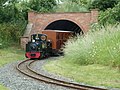
 'St Egwin' leaving Twyford on the EVLR - geograph.org.uk - 3055225.jpg 640 × 426; 108 KB
-
 'St Egwin' on the EVLR - geograph.org.uk - 3055226.jpg 640 × 398; 102 KB
-
 A Long Queue - geograph.org.uk - 989745.jpg 640 × 430; 78 KB
-

-
 A44 entering Chadbury - geograph.org.uk - 2381876.jpg 640 × 480; 60 KB
-
 A44 entering Chadbury - geograph.org.uk - 5294835.jpg 3,696 × 2,448; 2.45 MB
-
 A44 near Chadbury - geograph.org.uk - 5444071.jpg 640 × 427; 357 KB
-
 A44 near Charlton - geograph.org.uk - 5294844.jpg 3,696 × 2,448; 2.25 MB
-
 A44 near Wood Norton - geograph.org.uk - 2381882.jpg 640 × 480; 77 KB
-
 A44 roundabout - geograph.org.uk - 3858085.jpg 2,000 × 2,000; 663 KB
-
 A44 west of Wood Norton - geograph.org.uk - 2381885.jpg 640 × 480; 66 KB
-
 A44, The Squires - geograph.org.uk - 5444140.jpg 640 × 427; 316 KB
-
 A46 approaching Roundabout at Twyford - geograph.org.uk - 5175742.jpg 2,806 × 1,755; 1.6 MB
-
 A46 near Evesham - geograph.org.uk - 5444101.jpg 640 × 480; 386 KB
-
 A46 near Harvington - geograph.org.uk - 2054338.jpg 640 × 480; 43 KB
-
 A46 near Norton - geograph.org.uk - 5175728.jpg 2,757 × 1,708; 1.53 MB
-
 A46 near Twyford - geograph.org.uk - 2054317.jpg 640 × 480; 38 KB
-
 A46 north of Evesham - geograph.org.uk - 2279487.jpg 640 × 480; 42 KB
-
 A46 roundabout - geograph.org.uk - 3858062.jpg 2,000 × 1,322; 694 KB
-
 A46 Southbound - geograph.org.uk - 3787734.jpg 640 × 480; 259 KB
-
 A46, Twyford - geograph.org.uk - 3787832.jpg 640 × 480; 271 KB
-
 Approaching the A46 - geograph.org.uk - 2054310.jpg 640 × 480; 41 KB
-
 Arched entrance (geograph 6803553).jpg 768 × 1,024; 391 KB
-
 B4088 Evesham Road Norton - geograph.org.uk - 4496377.jpg 640 × 480; 65 KB
-
 B4088 heads north - geograph.org.uk - 3858228.jpg 1,500 × 1,972; 648 KB
-
 B4088 Norton Village Sign - geograph.org.uk - 4496360.jpg 640 × 485; 66 KB
-

-
 Bends for half a mile - geograph.org.uk - 3822694.jpg 2,000 × 1,426; 774 KB
-
 Beware tractors^ - geograph.org.uk - 2381853.jpg 640 × 480; 53 KB
-
 Bonfire at Evesham Country Park - geograph.org.uk - 3554255.jpg 4,724 × 3,543; 732 KB
-
 Bridge over the A46 - geograph.org.uk - 2054333.jpg 640 × 480; 50 KB
-
 Bus shelter on Evesham road - geograph.org.uk - 4626465.jpg 1,024 × 795; 162 KB
-

-
 Coach Park, Evesham Country Park - geograph.org.uk - 2370919.jpg 4,000 × 3,000; 4.11 MB
-
 Detail of the Golden Gates at Wood Norton - geograph.org.uk - 6246474.jpg 768 × 1,024; 275 KB
-
 Dismantled railway - geograph.org.uk - 3554187.jpg 2,000 × 1,500; 492 KB
-
 Double bend ahead - geograph.org.uk - 3822679.jpg 2,000 × 1,385; 773 KB
-
 Dougal on the Evesham Vale Light Railway, Twyford - geograph.org.uk - 2308209.jpg 3,821 × 2,867; 1.39 MB
-
 Electricity poles on the A44 - geograph.org.uk - 5294827.jpg 3,613 × 2,195; 3.16 MB
-
 Electricity Pylon near Manor Farm - geograph.org.uk - 5444075.jpg 640 × 481; 600 KB
-
 Entrance to Castle Fields Farm - geograph.org.uk - 3823299.jpg 2,000 × 1,462; 798 KB
-
 Entrance to The Valley - geograph.org.uk - 5307695.jpg 1,024 × 768; 111 KB
-
 Evesham , Evesham Country Park - geograph.org.uk - 2170168.jpg 4,128 × 2,586; 3.55 MB
-
 Evesham , Evesham Country Park - geograph.org.uk - 2170169.jpg 4,288 × 2,848; 4.89 MB
-
 Evesham , Evesham Country Park - geograph.org.uk - 2170171.jpg 4,288 × 2,848; 5.11 MB
-
 Evesham , Evesham Country Park - geograph.org.uk - 2170172.jpg 4,288 × 2,848; 4.79 MB
-
 Evesham , Evesham Country Park Garden Centre - geograph.org.uk - 2170173.jpg 4,288 × 2,848; 6.1 MB
-
 Evesham , Evesham Country Park Garden Centre - geograph.org.uk - 2170174.jpg 4,288 × 2,848; 5.29 MB
-
 Evesham , Evesham Country Park Garden Centre - geograph.org.uk - 2170175.jpg 2,848 × 4,288; 5.91 MB
-
 Evesham , Evesham Country Park Garden Centre - geograph.org.uk - 2170176.jpg 4,288 × 2,848; 5.33 MB
-
 Evesham , Evesham Country Park Garden Centre - geograph.org.uk - 2170177.jpg 4,288 × 2,848; 5.58 MB
-

-
 Evesham Country Park - geograph.org.uk - 4138886.jpg 1,024 × 768; 116 KB
-
 Evesham Country Park car park - geograph.org.uk - 2443271.jpg 3,008 × 2,000; 1.21 MB
-
 Evesham Road - geograph.org.uk - 3823322.jpg 2,000 × 1,445; 724 KB
-
 Evesham Road - geograph.org.uk - 5444137.jpg 640 × 427; 319 KB
-
 Evesham Road Approaching A44 - geograph.org.uk - 4496380.jpg 640 × 480; 65 KB
-

-
-
 Evesham Vale Light Railway - geograph.org.uk - 2533239.jpg 640 × 475; 111 KB
-
 Evesham Vale Light Railway - geograph.org.uk - 2534771.jpg 640 × 480; 103 KB
-
 Evesham Vale Light Railway - geograph.org.uk - 3856951.jpg 2,000 × 2,000; 722 KB
-
 Evesham Vale Light Railway - geograph.org.uk - 4111698.jpg 640 × 480; 103 KB
-
 Evesham Vale Light Railway - geograph.org.uk - 4111709.jpg 640 × 480; 112 KB
-

-

-

-
 Evesham Vale Light Railway Station - geograph.org.uk - 3598031.jpg 3,648 × 2,736; 2.38 MB
-
 Evesham Vale Light Railway's smaller station - geograph.org.uk - 4138894.jpg 1,024 × 768; 150 KB
-
 Evesham Vale Light Railway. - geograph.org.uk - 1826570.jpg 640 × 427; 102 KB
-

-
 Farmland east of Norton - geograph.org.uk - 3822408.jpg 2,000 × 1,333; 849 KB
-
 Farmland east of Norton - geograph.org.uk - 3822420.jpg 2,000 × 1,333; 762 KB
-
 Farmland near Norton - geograph.org.uk - 3823288.jpg 2,000 × 1,333; 727 KB
-
 Farmland View - geograph.org.uk - 840708.jpg 640 × 480; 92 KB
-
 Field north east of A46 - geograph.org.uk - 3856979.jpg 2,000 × 1,500; 751 KB
-
 Fields by the A44, Chadbury - geograph.org.uk - 6180607.jpg 1,876 × 1,210; 1.3 MB
-
 Fingerpost at Lenchwick - geograph.org.uk - 3289326.jpg 800 × 451; 178 KB
-
 Footpath crosses the A46 - geograph.org.uk - 3554279.jpg 2,000 × 1,415; 570 KB
-
 Footpath to Lenchwick - geograph.org.uk - 2375917.jpg 1,024 × 680; 178 KB
-
 Footpath to Rough Hills - geograph.org.uk - 2029792.jpg 3,008 × 2,000; 1.5 MB
-
 Former trackbed near Norton - geograph.org.uk - 2029598.jpg 3,008 × 2,000; 1.48 MB
-
 Greenhill - geograph.org.uk - 3856268.jpg 2,000 × 1,500; 672 KB
-
 Having A Picnic - geograph.org.uk - 840694.jpg 640 × 480; 108 KB
-
 Hay bales - geograph.org.uk - 2029603.jpg 3,008 × 2,000; 1.5 MB
-
 Hipton Hill - geograph.org.uk - 1726683.jpg 640 × 480; 269 KB
-
 Hipton Hill Orchards - geograph.org.uk - 1726677.jpg 640 × 480; 213 KB
-
 Horticultural land at Chadbury - geograph.org.uk - 2033097.jpg 3,008 × 2,000; 1.52 MB
-
 Houses on Greenhill - geograph.org.uk - 3858126.jpg 2,000 × 1,348; 713 KB
-
 Industrial buildings - geograph.org.uk - 4350605.jpg 800 × 450; 205 KB
-

-
 Junction of roads in Lenchwick - geograph.org.uk - 5595903.jpg 4,000 × 3,000; 2.91 MB
-
 Kingdom Hall Of Jehovah's Witnesses, Twyford - geograph.org.uk - 3856284.jpg 2,000 × 1,333; 717 KB
-
 Lay By on the Evesham Bypass - geograph.org.uk - 3787850.jpg 640 × 480; 255 KB
-
 Layby on the Northbound A46 near Evesham - geograph.org.uk - 5444104.jpg 640 × 480; 363 KB
-
 Layby, A46 - geograph.org.uk - 2493425.jpg 640 × 480; 75 KB
-
 Lodge and gate piers near Chadbury - geograph.org.uk - 2104541.jpg 640 × 440; 238 KB
-
 Lodge at the former entrance to Wood Norton - geograph.org.uk - 2033088.jpg 3,008 × 2,000; 1.49 MB
-
 Lodge near Chadbury - geograph.org.uk - 2104525.jpg 640 × 444; 216 KB
-
 Looking across the Evesham bypass, at Twyford - geograph.org.uk - 5660015.jpg 1,600 × 1,064; 211 KB
-
 Miniature railway station, Evesham Country Park - geograph.org.uk - 2538313.jpg 2,592 × 1,944; 2.21 MB
-
 Norton Farmhouse (geograph 6802528).jpg 1,024 × 768; 233 KB
-
 Norton Grange - geograph.org.uk - 2029777.jpg 3,008 × 2,000; 1.52 MB
-
 Of Course We'll Get It To Fly^ - geograph.org.uk - 840735.jpg 640 × 456; 77 KB
-
 Old main road, 1 - geograph.org.uk - 4350607.jpg 800 × 450; 197 KB
-
 Old main road, 2 - geograph.org.uk - 4350609.jpg 800 × 450; 177 KB
-
 Old Man's Beard - geograph.org.uk - 3858183.jpg 2,000 × 2,000; 781 KB
-
 Old Toll House by Green Hill, Twyford - geograph.org.uk - 6115358.jpg 640 × 449; 102 KB
-
 Old Toll House by the A44, Chadbury - geograph.org.uk - 6115035.jpg 640 × 456; 126 KB
-
 Orchard Farm - geograph.org.uk - 424028.jpg 640 × 480; 120 KB
-
 Orchard north of Norton - geograph.org.uk - 3823308.jpg 2,000 × 1,390; 814 KB
-
 Orchard west of A4184 - geograph.org.uk - 3856966.jpg 2,000 × 1,500; 783 KB
-
 Osier willow, Wood Norton - geograph.org.uk - 2033092.jpg 2,000 × 3,008; 1.52 MB
-
 Osier willows, Wood Norton - geograph.org.uk - 2033094.jpg 640 × 426; 123 KB
-
 Overbridge on A46 South Near Norton - geograph.org.uk - 4970128.jpg 640 × 480; 45 KB
-
 Parking Area on the A46 - geograph.org.uk - 5175721.jpg 2,796 × 1,689; 1.75 MB
-
 Part of Evesham Garden Centre - geograph.org.uk - 3598081.jpg 3,648 × 2,736; 2.83 MB
-
 Parting of the ways ahead - geograph.org.uk - 2381848.jpg 640 × 480; 69 KB
-
 Pike Cottages, Twyford Bank - geograph.org.uk - 2010605.jpg 640 × 480; 224 KB
-
 Plum trees, Norton - geograph.org.uk - 2029780.jpg 3,008 × 2,000; 1.48 MB
-
 Premier Inn, Evesham - geograph.org.uk - 4138890.jpg 1,024 × 768; 152 KB
-
 Premier Inn, Twyford, Evesham - geograph.org.uk - 5660017.jpg 1,600 × 1,064; 337 KB
-
 Pylons crossing Rough Hills - geograph.org.uk - 2030857.jpg 640 × 426; 91 KB
-
 Pylons on Rough Hills - geograph.org.uk - 2030845.jpg 2,000 × 3,008; 1.36 MB
-
 Ready for infill - geograph.org.uk - 5334049.jpg 1,024 × 768; 129 KB
-
 Restored Golden Gates at Wood Norton - geograph.org.uk - 6246465.jpg 1,024 × 768; 339 KB
-
 Restored Golden Gates at Wood Norton - geograph.org.uk - 6246471.jpg 768 × 1,024; 343 KB
-
 River Avon - geograph.org.uk - 2029304.jpg 3,008 × 2,000; 1.48 MB
-
 River Avon - geograph.org.uk - 2079706.jpg 3,072 × 2,304; 2.8 MB
-
 River Avon - geograph.org.uk - 3549926.jpg 2,000 × 1,500; 917 KB
-
 River Avon - geograph.org.uk - 3554207.jpg 2,000 × 1,333; 507 KB
-
 Road between Twyford and Lenchwick - geograph.org.uk - 2057498.jpg 640 × 426; 72 KB
-
 Road from Lenchwick to Church Lench - geograph.org.uk - 5595892.jpg 4,000 × 3,000; 4.04 MB
-
 Road to Lenchwick - geograph.org.uk - 2057505.jpg 640 × 426; 80 KB
-
 Rough meadowland, Wood Norton - geograph.org.uk - 2033081.jpg 3,008 × 2,000; 1.54 MB
-
 Rough Track to the River - geograph.org.uk - 2370908.jpg 4,000 × 3,000; 3.84 MB
-
 Roundabout on The Squires, Twyford - geograph.org.uk - 6155654.jpg 1,862 × 1,188; 1.15 MB
-
 Roundabout on Worcester Road, Evesham - geograph.org.uk - 6151581.jpg 1,920 × 1,280; 1.03 MB
-
 Roundabout on Worcester Road, Evesham - geograph.org.uk - 6155655.jpg 1,848 × 1,160; 1.22 MB
-
 Service road off Greenhill - geograph.org.uk - 3856974.jpg 2,000 × 1,500; 872 KB
-
 Southbound A46 - geograph.org.uk - 3787625.jpg 640 × 427; 239 KB
-
 Spring comes to Evesham Garden Centre - geograph.org.uk - 2291323.jpg 640 × 480; 282 KB
-
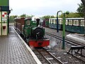
 St Egwin waits at the station - geograph.org.uk - 3858249.jpg 2,000 × 1,366; 739 KB
-
 St Egwin, Norton and Lenchwick, archway - geograph.org.uk - 4889034.jpg 640 × 480; 153 KB
-
-

-

-

-

-

-
 St Egwin, Norton and Lenchwick, east end - geograph.org.uk - 4889036.jpg 640 × 480; 119 KB
-

-

-

-

-
 Start of footpath towards the Avon - geograph.org.uk - 3858044.jpg 2,000 × 1,436; 772 KB
-
 Steam and Kites - geograph.org.uk - 1534455.jpg 640 × 397; 63 KB
-
 Tesco Petrol Station - geograph.org.uk - 5334044.jpg 1,024 × 768; 151 KB
-
 Texaco Filling Station, Evesham Services - geograph.org.uk - 3787845.jpg 640 × 427; 208 KB
-
 Thatched timber-framed cottage (geograph 6804414).jpg 1,024 × 768; 198 KB
-
 The Beefeater at Twyford - geograph.org.uk - 5334055.jpg 1,024 × 768; 262 KB
-
 The Norton Grange - geograph.org.uk - 3823269.jpg 2,000 × 1,333; 806 KB
-
 The Norton Grange - geograph.org.uk - 3823273.jpg 2,000 × 1,402; 838 KB
-
 The Norton Grange - geograph.org.uk - 3823277.jpg 2,000 × 1,408; 724 KB
-
 The Old Bell Cottage (geograph 6804398).jpg 1,024 × 768; 221 KB
-
 This Way To The Kite Demonstration - geograph.org.uk - 840713.jpg 640 × 482; 69 KB
-
 Three timber-framed cottages (geograph 6804418).jpg 1,024 × 768; 217 KB
-
 Through the trees on Rough Hills - geograph.org.uk - 2802917.jpg 640 × 480; 77 KB
-
 Timber-framed cottage (geograph 6804389).jpg 1,024 × 768; 247 KB
-
 Timber-framed cottage (geograph 6804407).jpg 1,024 × 768; 227 KB
-
 Timber-framed cottages (geograph 6804410).jpg 1,024 × 768; 213 KB
-
 Timber-framed granary (geograph 6802543).jpg 1,024 × 768; 224 KB
-
 Track down to the River Avon - geograph.org.uk - 3549879.jpg 2,000 × 1,333; 1.06 MB
-
 Track down to the River Avon - geograph.org.uk - 3554175.jpg 2,000 × 1,333; 621 KB
-
 Track into field off A46 - geograph.org.uk - 3856242.jpg 2,000 × 1,328; 677 KB
-
 Traffic island (roundabout) - geograph.org.uk - 1826521.jpg 640 × 360; 68 KB
-
 Train approaching EVLR's terminus station - geograph.org.uk - 4139100.jpg 1,024 × 768; 163 KB
-
 Train arriving at EVLR's terminus station - geograph.org.uk - 4139104.jpg 1,024 × 768; 242 KB
-
 Trees by the A44, Chadbury - geograph.org.uk - 6180606.jpg 1,920 × 1,280; 1.18 MB
-
 Trees with mistletoe on the A44 - geograph.org.uk - 5294830.jpg 3,696 × 2,448; 2.27 MB
-
 Turning for Lenchwick - geograph.org.uk - 2033098.jpg 3,008 × 2,000; 1.46 MB
-
-
 Twyford roundabout - geograph.org.uk - 3493498.jpg 3,648 × 2,736; 4.82 MB
-
 Tythe Barn Farm - geograph.org.uk - 3822451.jpg 2,000 × 1,333; 783 KB
-
 Under wraps - geograph.org.uk - 3554227.jpg 2,000 × 1,500; 553 KB
-
 View from Rough Hills - geograph.org.uk - 2030865.jpg 640 × 426; 86 KB
-
 View towards Premier Inn - geograph.org.uk - 3857054.jpg 2,000 × 1,340; 683 KB
-
 Welcome To Evesham Country Park - geograph.org.uk - 989753.jpg 640 × 456; 79 KB


.jpg)


.jpg)


_-_geograph.org.uk_-_4889038.jpg)
_-_geograph.org.uk_-_4889040.jpg)
_-_geograph.org.uk_-_4889042.jpg)
_-_geograph.org.uk_-_4889047.jpg)
_-_geograph.org.uk_-_4889044.jpg)


.jpg)


.jpg)

.jpg)

.jpg)
.jpg)
.jpg)
.jpg)


_-_geograph.org.uk_-_1826521.jpg)


