Category:Old maps of Freising
Subcategories
This category has only the following subcategory.
Media in category "Old maps of Freising"
The following 17 files are in this category, out of 17 total.
-

-
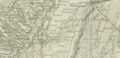
 Bishopric of Freising 18th century.jpg 1,200 × 1,600; 719 KB
-
 Freising 1816.png 4,226 × 5,580; 29.12 MB
-
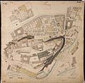
 Freising 1858.png 2,000 × 2,377; 10.74 MB
-
 Historico-Topographica Descriptio. 1. Das Renntambt München 281.jpg 18,235 × 7,685; 22.74 MB
-
 Hochstift freising fink.gif 350 × 500; 182 KB
-
 Karte Freising 1809.jpg 2,431 × 2,417; 968 KB
-
 Karte Freising nach Unterbruck von 1813.png 2,696 × 1,298; 5.21 MB
-
 Karte Freising Neustift 1810.jpg 2,465 × 2,441; 3.25 MB
-
 Karte Freising Nordosten 1809.jpg 2,480 × 2,448; 1.63 MB
-
 Karte Freising Süden&Domberg 1809.jpg 2,471 × 2,426; 4.13 MB
-
 Karte Freising Vötting ca 1810.jpg 2,440 × 2,396; 2.98 MB
-
 Karte Freising Westen 1809.jpg 2,459 × 2,449; 4.73 MB
-
 Kloster Neustift Plan 1803.png 2,914 × 1,607; 9.59 MB
-
 Lage Philippsschloss Freising.jpg 2,043 × 1,572; 3.49 MB
-
 Prince-Bishopric of Freising.jpg 1,200 × 1,600; 1.16 MB
-
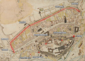 Stadtbefestigung Freising.png 1,665 × 1,189; 3.75 MB


.jpg)