Category:Old maps of Gotland County
Media in category "Old maps of Gotland County"
The following 29 files are in this category, out of 29 total.
-
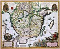
 "Gothia - Auctore Andrea Bareo Sueco." (22245350442).jpg 3,919 × 3,116; 2.3 MB
-
 Gotlandia - Porcacchi Tomaso - 1620.jpg 1,500 × 1,091; 1.31 MB
-
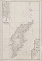 Admiralty Chart No 2250 Sweden sheet 5 Gotland, Published 1887.jpg 8,347 × 12,185; 7.79 MB
-
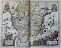
 Atlas Van der Hagen-KW1049B10 027-GOTHIA.jpeg 5,500 × 4,430; 4.15 MB
-
 Carte réduite de la Mer Baltique, IIIe Feuille - btv1b10567602g.jpg 12,533 × 8,491; 10.13 MB
-
 Folhammar - KMB - 16001000524544.jpg 800 × 602; 117 KB
-
 Gotland 1563-1570.jpg 2,048 × 1,591; 1.28 MB
-
 Gotland 1566.jpg 1,733 × 1,284; 1.99 MB
-
 Gotland, 1626 map by Andreas Bureus.jpg 675 × 900; 119 KB
-
 H88-1 7 Gotlands län Visby stad 1748 Lantmätare Johan fineman.png 2,048 × 1,839; 5.92 MB
-

-
 H88-1-26 Län Gotlands län Socken Visby stad 1697 grundritning över staden.png 1,969 × 2,048; 6.88 MB
-
 Karta öfver Gotland och Wisby – P A Säve 1858.jpg 1,406 × 1,599; 2.8 MB
-
 Karta över Visby med ruiner - KMB - 16001000044604.jpg 775 × 510; 113 KB
-
 Landskapskarta Gotland 1.png 4,729 × 2,639; 10.28 MB
-
 Landskapskarta Gotland 2.png 3,800 × 8,897; 36.67 MB
-
 Landskapskarta Gotland 3.png 3,636 × 8,859; 40.58 MB
-
 Landskapskarta Gotland 4.png 3,608 × 2,541; 10.44 MB
-
 Landskapskarta Gotland 5.png 1,278 × 2,777; 4.8 MB
-
 Ljunggren Wisby.png 2,105 × 2,855; 6.4 MB
-
 Neues Jahrbuch für Mineralogie, Geologie and Paläontologie (1888) (14580884667).jpg 2,224 × 3,820; 832 KB
-
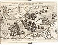
 Res gestae Friderici II Daniae Yb54-11.png 2,000 × 1,363; 6.21 MB
-
 Swenska wetenskaps academiens handlingar (1897) (14598195248).jpg 1,344 × 3,500; 822 KB
-
 Visby 1750 Lantmätare Johan fineman Grundritn m m över staden.png 1,556 × 2,047; 5.69 MB
-
 Visby J243-39-1 Generalstabskartan.png 2,048 × 1,599; 4.26 MB
-
 Wiblingen Visby.png 2,529 × 1,989; 6.78 MB
-

-

-
 Карта к статье «Готланд». Военная энциклопедия Сытина (Санкт-Петербург, 1911-1915).jpg 1,070 × 1,062; 171 KB
.jpg)


_(14580884667).jpg)


.jpg)
.jpg)
.jpg)
_(14598195248).jpg)