Category:Old maps of West Virginia
States of the United States: Alabama · Alaska · Arizona · Arkansas · California · Colorado · Connecticut · Delaware · Florida · Georgia · Hawaii · Idaho · Illinois · Indiana · Iowa · Kansas · Kentucky · Louisiana · Maine · Maryland · Massachusetts · Michigan · Minnesota · Mississippi · Missouri · Montana · Nebraska · Nevada · New Hampshire · New Jersey · New Mexico · New York · North Carolina · North Dakota · Ohio · Oklahoma · Oregon · Pennsylvania · Rhode Island · South Carolina · South Dakota · Tennessee · Texas · Utah · Vermont · Virginia · Washington · West Virginia · Wisconsin · Wyoming – District of Columbia: Washington, D.C.
Guam · Northern Mariana Islands · Puerto Rico
Guam · Northern Mariana Islands · Puerto Rico
Subcategories
This category has the following 6 subcategories, out of 6 total.
C
O
Media in category "Old maps of West Virginia"
The following 200 files are in this category, out of 368 total.
(previous page) (next page)-

-

-
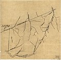
 (Map of part of Pocahontas, Randolph, and Webster counties, West Virginia). LOC 2004626976.tif 5,230 × 7,222; 108.06 MB
-

-

-
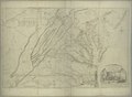
 A correct map of Virginia (NYPL b15376651-433675).jpg 6,300 × 5,248; 7.59 MB
-

-
-

-

-
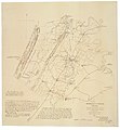
 Averill's map of western Va. LOC 99446734.jpg 7,397 × 9,804; 5.97 MB
-
 Averill's map of western Va. LOC 99446734.tif 7,397 × 9,804; 207.48 MB
-
 Barbour County, West Virginia LOC 81690038.jpg 6,114 × 7,304; 5.2 MB
-
 Barbour County, West Virginia LOC 81690038.tif 6,114 × 7,304; 127.76 MB
-

-

-
 Battle of Rich Mt. LOC 2003629675.jpg 2,003 × 3,060; 810 KB
-
 Battle of Rich Mt. LOC 2003629675.tif 2,003 × 3,060; 17.54 MB
-
 Berkeley County, Virginia LOC lva0000082.jpg 4,644 × 5,637; 2.51 MB
-
 Berkeley County, Virginia LOC lva0000082.tif 4,644 × 5,637; 74.9 MB
-
 Berkeley County, Virginia LOC lva0000083.jpg 5,208 × 5,613; 3.01 MB
-
 Berkeley County, Virginia LOC lva0000083.tif 5,208 × 5,613; 83.64 MB
-
 Berkeley County, West Virginia LOC 81690039.jpg 6,098 × 7,294; 5.12 MB
-
 Berkeley County, West Virginia LOC 81690039.tif 6,098 × 7,294; 127.26 MB
-

-
 Boundary, Gauley River National Recreation Area - exhibit "A" LOC 2007626188.jpg 11,114 × 7,573; 16.6 MB
-
 Boundary, Gauley River National Recreation Area - exhibit "A" LOC 2007626188.tif 11,114 × 7,573; 240.8 MB
-
 Cabell County, West Virginia - 1-100 000-scale topographic map LOC 96680319.jpg 9,027 × 7,275; 11.04 MB
-
 Cabell County, West Virginia - 1-100 000-scale topographic map LOC 96680319.tif 9,027 × 7,275; 187.89 MB
-
 Camp Garnett and vicinity, Rich Mountain, Randolph Co., Va. LOC 2002627474.jpg 1,996 × 2,974; 656 KB
-
 Campaigns of the civil war (1881) (14576063978).jpg 1,560 × 2,458; 355 KB
-

-
 Coal section of Flat-top Mountain LOC 2005625146.jpg 5,264 × 3,465; 2.38 MB
-
 Coal section of Flat-top Mountain LOC 2005625146.tif 5,264 × 3,465; 52.18 MB
-

-

-

-
 Dr. Hale's map of Cabin Creek lands. LOC 2005625160.jpg 6,085 × 5,980; 3.4 MB
-
 Dr. Hale's map of Cabin Creek lands. LOC 2005625160.tif 6,085 × 5,980; 104.11 MB
-
 EB1911 West Virginia.jpg 2,058 × 1,498; 1.53 MB
-
 EB9 West Virginia.jpg 3,824 × 2,810; 2.5 MB
-

-
 Electric railway journal (1910) (14574235388).jpg 2,981 × 2,302; 1.04 MB
-

-

-
 Farm line map of Marshall Co., West Virginia LOC 2012593061.jpg 13,016 × 14,180; 20.57 MB
-
 Fayette County, West Virginia LOC 81690032.jpg 8,509 × 7,574; 7.37 MB
-
 Fayette County, West Virginia LOC 81690032.tif 8,509 × 7,574; 184.39 MB
-
 Gauley River National Recreation Area LOC 2005630570.jpg 5,387 × 4,313; 2.47 MB
-
 Gauley River National Recreation Area LOC 2005630570.tif 5,387 × 4,313; 66.47 MB
-

-

-
 General soil map, Berkeley County, West Virginia LOC 00553853.jpg 7,317 × 8,800; 7.98 MB
-
 General soil map, Berkeley County, West Virginia LOC 00553853.tif 7,317 × 8,800; 184.22 MB
-

-

-
 Grafton, West Virginia 1898. LOC 75696682.jpg 8,832 × 6,432; 11.46 MB
-
 Greenbrier Battle.jpg 1,828 × 1,189; 923 KB
-
 Greenbrier County, West Virginia LOC 81690015.jpg 10,899 × 9,417; 11.5 MB
-
 Greenbrier County, West Virginia LOC 81690015.tif 10,899 × 9,417; 293.64 MB
-
 Hale's 8225 A Cabin Cr. LOC 2005630924.jpg 5,704 × 5,228; 2.53 MB
-
 Hale's 8225 A Cabin Cr. LOC 2005630924.tif 5,704 × 5,228; 85.32 MB
-
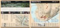
 Harpers Ferry National Historical Park, West Virginia LOC 83692555.jpg 10,388 × 4,962; 6.86 MB
-
 Harpers Ferry National Historical Park, West Virginia LOC 83692555.tif 10,388 × 4,962; 147.47 MB
-
 Harpers Ferry National Historical Park, West Virginia LOC 93685037.jpg 10,403 × 5,003; 7.08 MB
-
 Harpers Ferry National Historical Park, West Virginia LOC 93685037.tif 10,403 × 5,003; 148.91 MB
-
 Harpers Ferry National Historical Park, West Virginia LOC 93686798.jpg 10,449 × 5,011; 7.06 MB
-
 Harpers Ferry National Historical Park, West Virginia LOC 93686798.tif 10,449 × 5,011; 149.8 MB
-
 Harpers Ferry National Historical Park, West Virginia LOC 94681923.jpg 10,495 × 5,008; 7.03 MB
-
 Harpers Ferry National Historical Park, West Virginia LOC 94681923.tif 10,495 × 5,008; 150.37 MB
-
 Harpers Ferry National Historical Park, West Virginia LOC 96684101.jpg 10,326 × 4,986; 7.17 MB
-
 Harpers Ferry National Historical Park, West Virginia LOC 96684101.tif 10,326 × 4,986; 147.3 MB
-

-

-
 Harpers Ferry National Historical Park, West Virginia, Maryland. LOC 75690117.jpg 8,159 × 3,593; 4.28 MB
-
 Harpers Ferry National Historical Park, West Virginia, Maryland. LOC 75690117.tif 8,159 × 3,593; 83.87 MB
-

-

-

-

-

-

-

-

-

-

-

-
 Harrison County, West Virginia - 1-100 000-scale topographic map LOC 96680119.jpg 8,485 × 7,300; 10.29 MB
-
 Harrison County, West Virginia - 1-100 000-scale topographic map LOC 96680119.tif 8,485 × 7,300; 177.21 MB
-
 Harrison County, West Virginia LOC 81690040.jpg 6,132 × 7,285; 5.44 MB
-
 Harrison County, West Virginia LOC 81690040.tif 6,132 × 7,285; 127.81 MB
-
 Hunt's improved map of Wetzel County, W. V. LOC 2012593056.jpg 9,626 × 7,818; 8.84 MB
-
 Hunt's improved map of Wetzel County, W. V. LOC 2012593056.tif 9,626 × 7,818; 215.31 MB
-
 Hydrologic unit map-1974, State of West Virginia. LOC 76691412.jpg 11,242 × 10,184; 15.34 MB
-
 Hydrologic unit map-1989, State of West Virginia LOC 2005630517.jpg 11,242 × 10,298; 11.87 MB
-

-

-
 Insurance map of Charleston, W. Va. LOC 2006636200.jpg 11,592 × 10,951; 10.65 MB
-
 Jackson County, West Virginia LOC 81690035.jpg 6,146 × 8,784; 6.27 MB
-
 Jackson County, West Virginia LOC 81690035.tif 6,146 × 8,784; 154.46 MB
-
 Jefferson County, Virginia LOC lva0000084.jpg 4,179 × 4,676; 1.79 MB
-
 Jefferson County, Virginia LOC lva0000084.tif 4,179 × 4,676; 55.91 MB
-
 Jefferson County, West Virginia LOC 81690037.jpg 6,099 × 7,265; 4.44 MB
-
 Jefferson County, West Virginia LOC 81690037.tif 6,099 × 7,265; 126.77 MB
-
 JeffFryDetail.jpg 656 × 677; 102 KB
-
 Jenkins Trans-Allegheny Raid 1862V2.png 984 × 783; 1.81 MB
-

-
 Map of Berk(eley) County, Virginia LOC 2012593053.jpg 3,762 × 4,773; 2.66 MB
-
 Map of Berk(eley) County, Virginia LOC 2012593053.tif 3,762 × 4,773; 51.37 MB
-
 Map of Berkeley County, West Virginia LOC 2012593054.jpg 10,662 × 12,779; 15.04 MB
-
 Map of Berkeley County, West Virginia LOC 2012593054.tif 10,662 × 12,779; 389.81 MB
-
 Map of Gauly Farm, 1722 acres. LOC 2005625205.jpg 9,003 × 6,583; 6.46 MB
-
 Map of Gauly Farm, 1722 acres. LOC 2005625205.tif 9,003 × 6,583; 169.56 MB
-
 Map of Great Kanawha coal field showing location of mines. LOC 00556411.jpg 1,227 × 3,050; 739 KB
-
 Map of Great Kanawha coal field showing location of mines. LOC 00556411.tif 1,227 × 3,050; 10.71 MB
-
 Map of Greenbrier County, W.Va. - from actual survey LOC 2012593055.jpg 11,515 × 9,563; 11.25 MB
-
 Map of Hancock County Virginia, 1852. LOC 2006626015.jpg 6,903 × 10,320; 10.18 MB
-
 Map of Hancock County Virginia, 1852. LOC 2006626015.tif 6,903 × 10,320; 203.82 MB
-
 Map of Harper's Ferry.jpg 1,323 × 907; 591 KB
-

-

-

-
 Map of Jefferson County, Virginia LOC 2005625308.jpg 16,650 × 12,350; 23.3 MB
-
 Map of Jefferson County, Virginia LOC 2005625308.tif 16,650 × 12,350; 588.31 MB
-
 Map of Morgan County in West Virginia.jpg 2,373 × 1,410; 969 KB
-

-

-

-

-

-

-

-

-

-
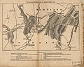
 Map of the battle ground of Greenbrier River (5120537295).jpg 2,000 × 1,367; 2.56 MB
-
 Map of the battle ground of Greenbrier River LOC lva0000081.jpg 5,415 × 3,728; 3.15 MB
-
 Map of the battle ground of Greenbrier River LOC lva0000081.tif 5,415 × 3,728; 57.76 MB
-
 Map of the battle ground of Greenbrier River. LOC 99446353.jpg 4,525 × 3,048; 2.18 MB
-
 Map of the battle ground of Greenbrier River. LOC 99446353.tif 4,525 × 3,048; 39.46 MB
-
 Map of the Logan County coal field in West Virginia LOC 2012593204.jpg 13,029 × 10,668; 19.4 MB
-
 Map of the Logan County coal field in West Virginia LOC 2012593204.tif 13,029 × 10,668; 397.66 MB
-

-

-

-
 Map of the New River Coalfield on C.& O. R.R. LOC 2005625166.jpg 3,526 × 5,008; 2.08 MB
-
 Map of the New River Coalfield on C.& O. R.R. LOC 2005625166.tif 3,526 × 5,008; 50.52 MB
-
 Map of the oil district of West Virginia. LOC 73696187.jpg 6,432 × 5,035; 5.06 MB
-
 Map of the oil district of West Virginia. LOC 73696187.tif 6,432 × 5,035; 92.65 MB
-

-
-

-

-
 Map of the Rich Mountain battlefield, W. Va. July 11-12, 1861. LOC 2003629668.jpg 1,376 × 2,108; 330 KB
-
 Map of the Rich Mountain battlefield, W. Va. July 11-12, 1861. LOC 2003629668.tif 1,376 × 2,108; 8.3 MB
-
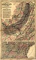
 Map of the State of Virginia (5960840069).jpg 2,000 × 1,284; 2.89 MB
-
 Map of the State of Virginia (6093615035).jpg 2,000 × 1,320; 3.16 MB
-

-
 Map of West Virginia showing railroads and county products (11842969584).jpg 2,000 × 1,442; 2.46 MB
-
 Map of West Virginia showing state routes LOC 91681295.jpg 9,492 × 8,650; 15.75 MB
-
 Map of West Virginia showing state routes LOC 91681295.tif 9,492 × 8,650; 234.91 MB
-
 Map of Woods (sic) County West Virginia (4231295479).jpg 1,357 × 2,000; 2.22 MB
-
 Map of Wyoming, Fayette and Raleigh Counties, West Va. LOC lva0000135.jpg 4,942 × 3,894; 912 KB
-
 Map of Wyoming, Fayette and Raleigh Counties, West Va. LOC lva0000135.tif 4,942 × 3,894; 55.06 MB
-

-
 Map showing land holdings in Muddlety Cr. Coal Field in Nicholas Co., W. Va. LOC 2005625169.tif 3,768 × 2,734; 29.47 MB
-

-
 Map showing location etc. of "Middleton" coal lands, Fayette County, W. Va. LOC 2005625168.tif 4,960 × 4,386; 62.24 MB
-

-

-

-

-
-

-

-

-

-
 Map showing the location of the "Herr" lands, Grant County, W. Va. LOC 2005625206.jpg 4,650 × 3,246; 1.41 MB
-
 Map showing the location of the "Herr" lands, Grant County, W. Va. LOC 2005625206.tif 4,650 × 3,246; 43.18 MB
-

-

-

-

-
 Map Showing the Norfolk - Wilmington and Charleston Railroad in 1891.jpg 5,627 × 8,578; 18.14 MB
-
 Map showing the preliminary line of the East River Railroad, May, 1881. LOC 98688653.jpg 9,896 × 4,512; 4.27 MB
-
 Map showing the preliminary line of the East River Railroad, May, 1881. LOC 98688653.tif 9,896 × 4,512; 127.75 MB
-
 Map showing the projected route of the Potomac and Ohio Railway. LOC 98688784.jpg 12,101 × 5,292; 11.29 MB
-
 Map showing the projected route of the Potomac and Ohio Railway. LOC 98688784.tif 12,101 × 5,292; 183.22 MB
-
 Map showing the West Virginia Midland Railway and its connections. LOC 98688852.jpg 7,787 × 5,812; 11.23 MB
-
 Map showing the West Virginia Midland Railway and its connections. LOC 98688852.tif 7,787 × 5,812; 129.48 MB
-
 Map to illustrate the report of Brigadier-General Hill LOC 99448907.jpg 2,840 × 2,278; 1 MB
-
 Map to illustrate the report of Brigadier-General Hill LOC 99448907.tif 2,840 × 2,278; 18.51 MB
-
-

-
 Marion County, West Virginia - 1-100 000-scale topographic map LOC 96680316.jpg 12,755 × 6,359; 12.86 MB
-
 Marion County, West Virginia - 1-100 000-scale topographic map LOC 96680316.tif 12,755 × 6,359; 232.06 MB
-
 Mason County, West Virginia LOC 81690034.jpg 7,904 × 11,443; 7.8 MB
-
 Mason County, West Virginia LOC 81690034.tif 7,904 × 11,443; 258.77 MB
-

-

-

._LOC_2004626976.jpg)

.jpg)
.jpg)


_(14576063978).jpg)

y._Surveyed_for_George_Washington_2950_acres_of_land_(by_virtue_of_a_warrant_for_5,000_acres_granted_by_His_Excellency_the_LOC_75693269.jpg)


_(14574235388).jpg)


.jpg)
_County,_Virginia_LOC_2012593053.jpg)


.jpg)


.jpg)
.jpg)
.jpg)
.jpg)

_County_West_Virginia_(4231295479).jpg)


._LOC_2005625209.jpg)


.jpg)