Category:Old maps of the Canadian Arctic region
Media in category "Old maps of the Canadian Arctic region"
The following 23 files are in this category, out of 23 total.
-

-
 HOOPER(1853) p459 THE COUNTRY OF THE TUSKI.jpg 3,281 × 2,470; 3.43 MB
-
 HEINZELMANN(1855) 16.1013 Kartenblatt Nordwestpassage.jpg 2,137 × 1,525; 1.74 MB
-
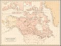 Arctic Regions and British America, Black, 1854.jpg 2,578 × 1,950; 4.68 MB
-
 Bradley Land.jpg 554 × 596; 67 KB
-
 Carte de Groenland (1647) - Isaac La Peyrère - 1 full.png 8,287 × 3,623; 30.42 MB
-
 Davisstraße (1700) 01.jpg 3,501 × 2,069; 5.45 MB
-
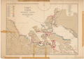
 Discoveries in the Arctic Regions, Ross, 1834.jpg 1,985 × 1,500; 2.5 MB
-

-
 Discoveries in the Arctic Sea up to MDCCCLIV LOC 2018593012.jpg 14,224 × 11,760; 19.03 MB
-
 Discoveries in the Arctic Sea with additions and changes to 1909 11-c.170-1909b.png 24,267 × 19,917; 1.35 GB
-
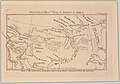 Discoveries of Messrs. Dease and Simpson in 1838-9 (14166789030).jpg 2,500 × 1,745; 1.78 MB
-
 Explorations in Northern Canada and adjacent portions of Greenland and Alaska 1904 11-c.170-1904.png 24,957 × 17,613; 1.23 GB
-
 Franklin 11-c.170-1911-s3168k.png 20,170 × 20,670; 1.17 GB
-
 Franz Boas map.png 372 × 484; 20 KB
-

-

-

-
 Luke Foxe voyage account (North-West Fox, 1635) - 2 foldout map -1 full view.png 5,742 × 4,226; 39.96 MB
-
 Luke Foxe voyage account (North-West Fox, 1635) - 3 foldout map - 2 Hudson Bay.png 1,539 × 1,360; 4.46 MB
-
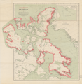
 Map of Canada's Arctic Archipelago, circa 1903.jpg 2,000 × 2,654; 4.63 MB
-

-
 Wellington Channel Melville Island &c from Admiralty Chart 1862.jpg 2,257 × 1,200; 2.24 MB
%27_(11090299473).jpg)
_p459_THE_COUNTRY_OF_THE_TUSKI.jpg)
_16.1013_Kartenblatt_Nordwestpassage.jpg)


_-_Isaac_La_Peyr%C3%A8re_-_1_full.png)
_01.jpg)


.jpg)


_-_3_fig_2_-_map_of_Hudson_Strait_and_Hudson_Bay.png)
_-_4_double_page_with_fig_3_-_Winter_Harbour.png)
_-_5_fig_3_-_Winter_Harbour_at_Churchill_River_-_1_full.png)
_-_2_foldout_map_-1_full_view.png)
_-_3_foldout_map_-_2_Hudson_Bay.png)

_-_2_foldout_map_The_Platt_of_Sayling_-_1_full_view.png)
