Category:Othery
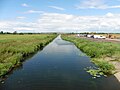
English: The parish and village of Othery, established in 1515, sits on a detached extension of Sowy island on the Somerset Levels. It is north-west of Langport. It borders the hamlets and villages of Pathe, Burrowbridge, Middlezoy, Westonzoyland and Aller, which it meets at Beer Wall. The border with Burrowbridge was defined in 1985, reducing Othery to 553 ha (1,366 acres). Many of these borders are defined by rhynes (ditches) and walls (embankments) created and rearranged, from the 13th century onwards, to drain and channel the waters of the River Cary and the River Parrett as they flooded the low-lying levels on their leisurely journey to the Bristol Channel.
village in the United Kingdom  | |||||
| Upload media | |||||
| Instance of | |||||
|---|---|---|---|---|---|
| Location | Sedgemoor, Somerset, South West England, England | ||||
| Said to be the same as | Othery (Wikimedia duplicated page, civil parish) | ||||
 | |||||
Subcategories
This category has only the following subcategory.
M
- St Michael's church, Othery (6 F)
Media in category "Othery"
The following 66 files are in this category, out of 66 total.
-
 A361, Othery - geograph.org.uk - 4438591.jpg 800 × 533; 143 KB
-
 A361, Othery - geograph.org.uk - 4438606.jpg 800 × 533; 141 KB
-
 Barrow Wall Farm - geograph.org.uk - 4618660.jpg 640 × 480; 151 KB
-
 Bedwell Lane - geograph.org.uk - 2077963.jpg 640 × 464; 98 KB
-
 Beer Wall - geograph.org.uk - 4438620.jpg 800 × 449; 120 KB
-
 Beer Wall on the A372, looking west - geograph.org.uk - 4618663.jpg 640 × 480; 160 KB
-
 Beer Wall Sluice - geograph.org.uk - 4438637.jpg 800 × 800; 256 KB
-
 Bimpits Rhyne - geograph.org.uk - 5328548.jpg 1,024 × 842; 236 KB
-
 Burrow Wall - geograph.org.uk - 4438581.jpg 800 × 533; 239 KB
-
 Burrow Wall near Pathe - geograph.org.uk - 4604344.jpg 3,456 × 2,304; 2 MB
-
 Cattle by Two Mile Rhyne - geograph.org.uk - 6151473.jpg 3,606 × 2,373; 967 KB
-
 Cemetery at Othery - geograph.org.uk - 4089213.jpg 640 × 480; 178 KB
-
 Cottages at Pathe Bridge - geograph.org.uk - 4604347.jpg 3,456 × 2,304; 1.54 MB
-
 Drainage channel by Beer Drove - geograph.org.uk - 6151429.jpg 3,908 × 2,676; 1.61 MB
-
 Field near Othery - geograph.org.uk - 4438587.jpg 800 × 533; 172 KB
-
 Flood water near Othery - geograph.org.uk - 3893568.jpg 800 × 600; 78 KB
-
 Fore Street (A361) - geograph.org.uk - 3306838.jpg 640 × 480; 73 KB
-
 Fore Street, Othery - geograph.org.uk - 2077485.jpg 640 × 427; 62 KB
-
 Fore Street, Othery - geograph.org.uk - 2078042.jpg 640 × 454; 74 KB
-
 Fore Street, Othery - geograph.org.uk - 5035572.jpg 1,024 × 768; 160 KB
-
 Interesting colour scheme - geograph.org.uk - 4990434.jpg 1,024 × 890; 263 KB
-

-
 King's Sedge Moor, Somerset Levels - geograph.org.uk - 4072633.jpg 1,024 × 768; 132 KB
-
 Laneside - geograph.org.uk - 2077535.jpg 640 × 480; 122 KB
-
 Langacre Rhyne - geograph.org.uk - 1803986.jpg 640 × 428; 67 KB
-
 Langacre Rhyne - geograph.org.uk - 4438617.jpg 800 × 800; 165 KB
-
 Levels near Othery - geograph.org.uk - 1804026.jpg 640 × 480; 87 KB
-
 Main Road Through Othery - geograph.org.uk - 1434251.jpg 640 × 480; 64 KB
-
 Maisey's bakery, Othery - geograph.org.uk - 5612123.jpg 1,600 × 1,200; 647 KB
-
 Major engineering works at Beer Wall - geograph.org.uk - 5035557.jpg 1,024 × 768; 166 KB
-
 Moors off Burrow Wall - geograph.org.uk - 4438578.jpg 800 × 533; 153 KB
-

-
 Othery church from the road - geograph.org.uk - 4604356.jpg 2,216 × 3,232; 846 KB
-
 Othery Village Hall - geograph.org.uk - 4438602.jpg 800 × 533; 193 KB
-
 Othery Village School - geograph.org.uk - 1434244.jpg 640 × 480; 96 KB
-
 Palmers Hern Rhyne - geograph.org.uk - 2043733.jpg 640 × 480; 111 KB
-
 Pathe - geograph.org.uk - 2043642.jpg 640 × 480; 89 KB
-
 Road junction, Beer Door - geograph.org.uk - 4072602.jpg 1,024 × 768; 166 KB
-
 Second Drove - geograph.org.uk - 5035510.jpg 1,024 × 784; 164 KB
-
 Signpost at Beer Door - geograph.org.uk - 4072623.jpg 1,024 × 768; 136 KB
-
 Somerset Levels near Othery - geograph.org.uk - 1887888.jpg 640 × 481; 126 KB
-
 Southlake Moor - geograph.org.uk - 2077631.jpg 640 × 480; 107 KB
-
 Sowey River - geograph.org.uk - 1226673.jpg 640 × 480; 47 KB
-
 Sowey River - geograph.org.uk - 128560.jpg 640 × 426; 114 KB
-
 Sowy River - geograph.org.uk - 2078118.jpg 640 × 480; 66 KB
-
 Sowy River - geograph.org.uk - 5035514.jpg 1,024 × 768; 148 KB
-
 Sowy River in winter, near Othery - geograph.org.uk - 1127586.jpg 640 × 480; 186 KB
-
 Sowy River, Somerset Levels - geograph.org.uk - 103666.jpg 640 × 475; 161 KB
-
 Summerhedge Road - geograph.org.uk - 2077525.jpg 487 × 640; 96 KB
-
 Temporary shop and post office Othery - geograph.org.uk - 4604359.jpg 3,456 × 2,304; 3.47 MB
-
 The London Inn, Othery - geograph.org.uk - 4618661.jpg 640 × 480; 138 KB
-
 Track and Rhyne near Othery - geograph.org.uk - 1804031.jpg 640 × 480; 89 KB
-
 Track and Rhyne near Shride Farm - geograph.org.uk - 1804013.jpg 640 × 480; 91 KB
-
 Track junction near Othery - geograph.org.uk - 2078009.jpg 640 × 480; 94 KB
-
 Turn Hill provides a panoramic view of Floods - geograph.org.uk - 3853428.jpg 1,920 × 1,080; 830 KB
-
 Two Mile Rhyne - geograph.org.uk - 5128081.jpg 1,024 × 768; 176 KB
-
 View Middlezoy to Othery - geograph.org.uk - 4604352.jpg 3,456 × 2,304; 1.6 MB
-
 View near the Sowy River - geograph.org.uk - 3853807.jpg 800 × 600; 81 KB
-
 View towards Shride Farm - geograph.org.uk - 5328560.jpg 1,024 × 767; 279 KB
-
 Aller Moor Pumping Station - geograph.org.uk - 1156045.jpg 640 × 405; 78 KB
-
 Cottage On Lane To Middlezoy - geograph.org.uk - 1435529.jpg 640 × 480; 102 KB
-
 Cows Crossing - geograph.org.uk - 427381.jpg 640 × 412; 66 KB
-
 Farm Buildings - geograph.org.uk - 128556.jpg 640 × 426; 127 KB
-
-
 Othery Cemetery - geograph.org.uk - 115700.jpg 640 × 475; 99 KB
-
 The London Inn. Othery - geograph.org.uk - 115702.jpg 640 × 480; 94 KB


_-_geograph.org.uk_-_3306838.jpg)


,_alongside_Beer_Drove_-_geograph.org.uk_-_4072638.jpg)


