Category:Oude Boteringestraat 19 (Groningen)
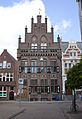
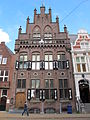
Nederlands: Oude Boteringestraat 19, Groningen (1913, J.A. Mulock Houwer, gem.mon. 102895)
| Object location | | View all coordinates using: OpenStreetMap |
|---|
|
This is a category about a municipal monument in Groningen with number 102895 |
Media in category "Oude Boteringestraat 19 (Groningen)"
The following 9 files are in this category, out of 9 total.
-
 0014-102895-LR.jpg 791 × 1,149; 895 KB
-
 20111016 Broerstraat Groningen NL.jpg 4,200 × 2,400; 3.27 MB
-
 Groningen Oude Boteringstraat.jpg 2,169 × 3,000; 5.45 MB
-
 LG-Groningen- Oude Boteringestraat 19.JPG 2,112 × 2,816; 1.94 MB
-
 Oude Boteringestraat 19 (1).jpg 2,909 × 4,364; 9.35 MB
-
 Oude Boteringestraat 19 (2).jpg 3,243 × 4,054; 9.24 MB
-
 Oude Boteringestraat 19 (3).jpg 4,227 × 2,818; 8.77 MB
-
 Voor- en zijgevel - Groningen - 20093574 - RCE.jpg 805 × 1,200; 256 KB
-
 Voorgevel - Groningen - 20093576 - RCE.jpg 808 × 1,200; 234 KB


.jpg)
.jpg)
.jpg)

