Category:Pakhuis Zwolle (Amsterdam)
| Object location | | View all coordinates using: OpenStreetMap |
|---|
 | |||||
| Upload media | |||||
| Instance of | |||||
|---|---|---|---|---|---|
| Part of |
| ||||
| Named after | |||||
| Location | Amsterdam, North Holland, Netherlands | ||||
| Street address |
| ||||
| Located on street | |||||
| Heritage designation |
| ||||
 | |||||
|
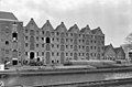
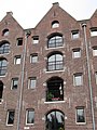
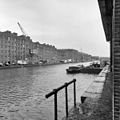
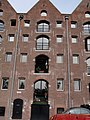
This is a category about rijksmonument number 1086
|
| Address |
|
Media in category "Pakhuis Zwolle (Amsterdam)"
The following 13 files are in this category, out of 13 total.
-
 Amsterdam - Entrepotdok - Zwolle.JPG 3,056 × 4,592; 5.66 MB
-
 Dak - Amsterdam - 20011334 - RCE.jpg 1,200 × 789; 150 KB
-
 Dak - Amsterdam - 20011335 - RCE.jpg 1,200 × 802; 218 KB
-

-
 Entredok-3.JPG 3,648 × 2,736; 2.01 MB
-
 Entrepotdok - Amsterdam (9).JPG 1,536 × 2,048; 1.47 MB
-
 Overzicht - Amsterdam - 20011304 - RCE.jpg 1,198 × 1,200; 272 KB
-
 Overzicht 51-84 - Amsterdam - 20011312 - RCE.jpg 1,178 × 1,200; 278 KB
-
 Overzicht 75-84 - Amsterdam - 20011316 - RCE.jpg 1,188 × 1,200; 269 KB
-
 Overzicht 76-84 - Amsterdam - 20011318 - RCE.jpg 1,190 × 1,200; 295 KB
-
 Overzicht 79-84 - Amsterdam - 20011319 - RCE.jpg 1,192 × 1,200; 347 KB
-
 Rm-1086.JPG 2,736 × 3,648; 2.02 MB
-
 Rm1080-4.JPG 3,648 × 2,736; 2.27 MB


.JPG)


