Category:Panoramics in Queensland
Subcategories
This category has the following 3 subcategories, out of 3 total.
Media in category "Panoramics in Queensland"
The following 183 files are in this category, out of 183 total.
-
 12895840713 Jpg (175372441).jpeg 2,048 × 461; 236 KB
-
 And over the way - panoramio.jpg 5,104 × 1,360; 1.26 MB
-
 Around the corner - panoramio.jpg 4,736 × 1,280; 892 KB
-
 Caloundra Queensland 2.jpg 1,200 × 400; 27 KB
-
 Caloundra Queensland.jpg 800 × 267; 23 KB
-
 Cape York Peninsula Looking South 001.jpg 17,640 × 3,310; 30.24 MB
-
 Carney's Creek Drive - panoramio.jpg 4,912 × 1,080; 951 KB
-
 Construction at Brisbane Airport - panoramio.jpg 3,946 × 1,072; 827 KB
-
 Entrance to Glass House Mountains National Park, Mount Beerburrum Section - panoramio.jpg 4,896 × 1,280; 1.11 MB
-
 Glass House Mountains QLD 4518, Australia - panoramio.jpg 4,864 × 1,280; 1.12 MB
-
 Glass House Mountains.jpg 2,500 × 926; 769 KB
-
 Hitchenbrook Sunrise - panoramio.jpg 4,112 × 896; 686 KB
-
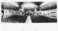
 Hou Wang Temple.jpg 11,805 × 3,893; 11.5 MB
-
 Kangaroo Point Cliffs, Brisbane seen from across the river.jpg 4,096 × 1,114; 1.53 MB
-
 Lake Moogerah 04.jpg 10,590 × 3,882; 12.78 MB
-
 Mackay Banner.jpg 2,506 × 360; 264 KB
-
 Mackay, Queensland - Panorama at Rats of Tobruk Memorial at Queen's Park.jpg 2,983 × 360; 312 KB
-
 Mary Cairncross Reserve lookout.jpg 2,500 × 728; 475 KB
-
 Milton ferry wharf, Milton, Queensland pano.jpg 4,096 × 1,447; 1.67 MB
-
 Montville lookout.jpg 3,000 × 733; 808 KB
-
 Moogerah Dam, Queensland 11.jpg 7,426 × 3,466; 7.68 MB
-
 Moogerah Dam, Queensland 13.jpg 11,780 × 3,658; 13.23 MB
-

-
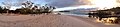 Panoramic sunset at Wathumba Creek, Fraser Island.jpg 4,096 × 917; 1.22 MB
-
 Port Douglas 300 degree Panaramic out to sea.jpg 2,403 × 398; 277 KB
-
 Proserpine Lawn Cemetery Panorama.jpg 4,096 × 1,139; 1.64 MB
-

-

-

-

-

-

-
 Queensland State Archives 2466 Mount Walker near Maroon 1894.png 720 × 267; 260 KB
-

-

-
-

-
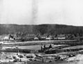
 Queensland State Archives 4737 Panorama of the tobacco farm Clare c 1952.png 1,020 × 545; 213 KB
-
 Queensland State Archives 6369 Panorama of Manly Boat Harbour c 1959.png 1,084 × 247; 136 KB
-

-
 Rossmoya.jpg 9,955 × 1,231; 2.71 MB
-
 StateLibQld 1 102592 Railway bridge and the town of Stanthorpe, ca. 1882.jpg 1,000 × 764; 126 KB
-
 StateLibQld 1 103155 Panoramic view of Mungana, ca. 1909.jpg 1,000 × 738; 78 KB
-

-
-
 StateLibQld 1 108928 Panoramic view of Eidsvold, 1931.jpg 1,000 × 384; 59 KB
-
 StateLibQld 1 110108 View of Warwick, Queensland, ca. 1875.jpg 1,000 × 746; 152 KB
-
-
 StateLibQld 1 111192 View of South Brisbane along Stanley Street, ca. 1869.jpg 1,000 × 684; 108 KB
-
 StateLibQld 1 112244 View of Warwick, ca. 1875.jpg 881 × 1,000; 155 KB
-
 StateLibQld 1 113340 View of Warwick, Queensland, ca. 1875.jpg 1,000 × 742; 138 KB
-
 StateLibQld 1 114360 Panoramic view of Burleigh Heads, Queensland, ca. 1951.jpg 1,000 × 726; 112 KB
-

-
 StateLibQld 1 119784 Panorama from Albion towards Bowen Hills, ca. 1915.jpg 1,000 × 624; 79 KB
-

-
 StateLibQld 1 124528 Panorama from Albion, 1924.jpg 1,000 × 578; 65 KB
-
 StateLibQld 1 124987 Wellington Point view, ca. 1901.jpg 1,000 × 723; 133 KB
-

-
-
-

-
 StateLibQld 1 137159 View of Auckland Creek, Gladstone, ca. 1870.jpg 1,000 × 658; 60 KB
-
 StateLibQld 1 15786 Bayside view of Wynnum as seen from Manly Hill, ca. 1910.jpg 1,000 × 701; 108 KB
-
 StateLibQld 1 160787 Laying of the railway line at Stanthorpe, ca. 1880.jpg 1,000 × 752; 150 KB
-

-
-
 StateLibQld 1 196283 Panorama of Port Douglas, Queensland, ca. 1927.jpg 1,000 × 186; 38 KB
-

-
-

-
 StateLibQld 1 203608 Panaromic view of Warwick, 1897.jpg 1,000 × 754; 81 KB
-
 StateLibQld 1 208101 Macknade Sugar Mill, Ingham, Queensland, ca. 1930.jpg 1,000 × 673; 79 KB
-

-
 StateLibQld 1 233866 Panorama of the Maroochy River (detail) ca. 1905.jpg 1,000 × 173; 26 KB
-

-

-

-
 StateLibQld 1 242143 Panoramic view of Gladstone, 1937-1938.jpg 1,000 × 601; 97 KB
-

-
 StateLibQld 1 256557 North Head lighthouse, Bowen, 1921.jpg 1,000 × 748; 55 KB
-

-
 StateLibQld 1 258446 Millchester Road, Charters Towers, 1904.jpg 1,000 × 696; 107 KB
-
 StateLibQld 1 258727 Panoramic view of Bowen, North Queensland, ca. 1915.jpg 1,000 × 638; 117 KB
-

-
 StateLibQld 1 258865 Overlooking the jetty at Innisfal, 1930.jpg 1,000 × 576; 110 KB
-
 StateLibQld 1 258893 View across the Johnstone River to Innisfail, 1930.jpg 1,000 × 572; 83 KB
-

-
 StateLibQld 1 292215 View of Tweed Heads from Razorback, ca. 1925.jpg 1,000 × 613; 86 KB
-
 StateLibQld 1 294035 Tweed Heads, showing Dividing Fence, ca. 1904.jpg 1,000 × 625; 92 KB
-
 StateLibQld 1 294639 Tweed Heads looking from Greenmount, ca. 1910.jpg 1,000 × 600; 75 KB
-
 StateLibQld 1 295623 Mouth of Tweed River, 1905.jpg 1,000 × 689; 77 KB
-
 StateLibQld 1 295959 View of Tweed Heads from Razorback, ca. 1942.jpg 1,000 × 550; 58 KB
-
 StateLibQld 1 295999 View of Tweed Heads from Razorback, ca. 1920.jpg 1,000 × 589; 61 KB
-

-
 StateLibQld 1 296259 River mouth, Tweed River, ca. 1934.jpg 1,000 × 566; 54 KB
-
 StateLibQld 1 298319 View of Tweed Heads, ca. 1930.jpg 1,000 × 577; 46 KB
-
 StateLibQld 1 298487 Tweed River view, ca. 1901.jpg 1,000 × 752; 89 KB
-
 StateLibQld 1 298559 Tweed River from Razorback, 1942.jpg 1,000 × 691; 79 KB
-
 StateLibQld 1 298623 Tweed River, ca. 1925.jpg 1,000 × 657; 76 KB
-
 StateLibQld 1 298683 View over Tweed Heads, ca. 1918.jpg 1,000 × 233; 36 KB
-

-
 StateLibQld 1 395821 Boyd's Bay Ferry, ca. 1932.jpg 1,000 × 620; 84 KB
-
 StateLibQld 1 395893 Boyd's Bay Ferry, ca. 1910.jpg 1,000 × 593; 89 KB
-
 StateLibQld 1 51016 Raspberry Creek homestead, ca. 1865.jpg 1,000 × 604; 107 KB
-
 StateLibQld 1 82627 View from the Newstead residence of Folkestone, 1885.jpg 1,000 × 758; 119 KB
-
 StateLibQld 2 117552 Panoramic view of Daintree, Queensland, 1936.jpg 1,000 × 468; 48 KB
-

-
 StateLibQld 2 130303 Panoramic view of Upper Freestone, 1914.jpg 1,000 × 417; 44 KB
-
 StateLibQld 2 151847 Overlooking the mine buildings at Mount Morgan, 1902.jpg 1,000 × 745; 113 KB
-
 StateLibQld 2 15722 Southern end of Mt. Morgan town, 1913.jpg 1,000 × 573; 68 KB
-

-
-
 StateLibQld 2 180407 Looking down on the town of Eidsvold, 1911.jpg 1,000 × 962; 73 KB
-
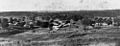
 StateLibQld 2 190155 Rural settlement of Stanthorpe in 1909.jpg 1,000 × 628; 125 KB
-
 StateLibQld 2 190159 Rural scene at Stanthorpe in 1909.jpg 1,000 × 624; 121 KB
-
-
 StateLibQld 2 198963 Panoramic views from Buderim to Mooloolaba Beach, 1934.jpg 1,000 × 599; 101 KB
-
 StateLibQld 2 206793 Mount Archer from Hospital Hill, Kilcoy, 1927.jpg 597 × 1,000; 70 KB
-

-

-
 StateLibQld 2 235049 Brisbane area in 1886.jpg 1,000 × 612; 98 KB
-
 StateLibQld 2 235061 Buildings in the centre of Brisbane, 1886.jpg 1,000 × 543; 78 KB
-

-

-
 StateLibQld 2 235113 Looking down Wickham Terrace towards the city, 1886.jpg 1,000 × 596; 83 KB
-
 StateLibQld 2 235153 View of Brisbane in 1863.jpg 1,000 × 538; 103 KB
-
 StateLibQld 2 235157 View of Brisbane looking towards the river, 1860.jpg 1,000 × 625; 109 KB
-
 StateLibQld 2 235165 Wickham Terrace from the Observatory, Brisbane, 1863.jpg 1,000 × 537; 103 KB
-

-

-

-

-
 StateLibQld 2 253584 Panoramic view of the Alberton Sugar Mill, 1922.jpg 1,000 × 293; 57 KB
-
 StateLibQld 2 254408 Early scene of Brisbane, 1862.jpg 1,000 × 788; 128 KB
-
 StateLibQld 2 254640 View from Government House, Brisbane, 1932.jpg 1,000 × 722; 93 KB
-
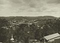
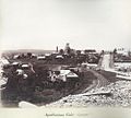 StateLibQld 2 255634 Apollonian Vale, Gympie, ca. 1890.jpg 1,000 × 901; 114 KB
-
 StateLibQld 2 256614 Bandstand features in the centre of town, Mt. Isa, 1931.jpg 1,000 × 816; 129 KB
-
 StateLibQld 2 256694 Elevated view of the mining town of Mt. Isa, 1932.jpg 1,000 × 692; 95 KB
-

-
 StateLibQld 2 256874 Mount Isa smelting works as seen from town, 1932.jpg 1,000 × 723; 90 KB
-
 StateLibQld 2 256878 Mount Isa township, 1932.jpg 1,000 × 720; 103 KB
-

-
 StateLibQld 2 256902 Panoramic view of Mt. Isa, 1932.jpg 1,000 × 269; 49 KB
-
 StateLibQld 2 256934 Power plant for the Mt. Isa mines, 1932.jpg 1,000 × 673; 73 KB
-
 StateLibQld 2 256954 Shaft, powerhouse and smelter at Mt. Isa Mines, 1932.jpg 1,000 × 767; 100 KB
-
 StateLibQld 2 257006 Supply shaft and mine buildings at Mt. Isa, 1932.jpg 1,000 × 682; 100 KB
-
 StateLibQld 2 257010 Supply shaft and the town, Mt. Isa, 1932.jpg 1,000 × 689; 120 KB
-
 StateLibQld 2 257317 Looking from Mt. Playfair across the ranges, 1916.jpg 1,000 × 641; 88 KB
-

-

-

-
 StateLibQld 2 257599 View of Round Hill and then dam, Copperfield, 1876.jpg 1,000 × 620; 109 KB
-

-
 StateLibQld 2 292159 Early view of Mount Isa township, 1929.jpg 1,000 × 643; 100 KB
-

-
-

-
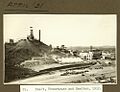
 StateLibQld 2 297631 Open cut mine at Mount Morgan, 1952.jpg 1,000 × 683; 128 KB
-
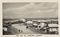
 StateLibQld 2 299574 Panorama of Caloundra, 1900.jpg 1,000 × 152; 25 KB
-
 StateLibQld 2 393793 Garrows Hut on Soldiers Road, Bunya Mountains, 1924.jpg 1,000 × 432; 28 KB
-

-
 StateLibQld 2 394165 Mountain ridges, Bunya Mountains, ca. 1920.jpg 1,000 × 735; 117 KB
-

-
 StateLibQld 2 394213 Panoramic view of Bunya Mountains, ca. 1920.jpg 1,000 × 614; 49 KB
-
 StateLibQld 2 394277 Man and his car on Bunya Mountains, 1924.jpg 1,000 × 511; 44 KB
-
 StateLibQld 2 395773 Fairymead Sugar Mill, Bundaberg, 1935.jpg 1,000 × 649; 98 KB
-
 StateLibQld 2 50060 Panoramic view of Kilcoy, 1939.jpg 1,000 × 460; 96 KB
-
 StateLibQld 2 66979 Chillagoe, North Queensland, ca. 1905.jpg 1,000 × 626; 116 KB
-
 StateLibQld 2 67469 Panorama of Marburg.jpg 1,000 × 629; 112 KB
-

-

-
 Staying Still 33 - Landsborough Highway.jpg 5,120 × 1,250; 4.56 MB
-
 Staying Still 49 - Cooktown and the Endeavour River.jpg 5,120 × 1,233; 4.71 MB
-
 Switchback four - panoramio.jpg 4,864 × 1,264; 1.34 MB
-
 Switchback one - panoramio.jpg 4,880 × 1,296; 1.24 MB
-
 Switchback two - panoramio.jpg 4,960 × 1,248; 1.2 MB
-
 The 2018 Commonwealth Games Village, Gold Coast, Queensland, Australia.jpg 3,044 × 1,536; 1.28 MB
-
 The end of the road - panoramio (1).jpg 4,880 × 1,296; 1.1 MB
-
 The Gold Coast, QLD skyline.jpg 1,024 × 192; 143 KB
-
 The reservoirs - panoramio.jpg 5,072 × 1,392; 1.23 MB
-
 The sun setting in Coombabah Lake Conservation Park.jpg 5,264 × 2,510; 5.18 MB
-
 Turnoff to Mt Beerburrum - panoramio.jpg 4,816 × 1,264; 914 KB
-
 Wallaman falls panorama.jpg 4,384 × 1,966; 7.59 MB


.jpeg)
_ca._1905.jpg)
.jpg)