Category:Parkside Road bridge, Newton-le-Willows (DSE)
| Object location | | View all coordinates using: OpenStreetMap |
|---|
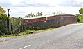
This bridge, DSE/99, carries Parkside Road (A573) over the Liverpool and Manchester Lines to the west of Newton-le-Willows.
Media in category "Parkside Road bridge, Newton-le-Willows (DSE)"
The following 4 files are in this category, out of 4 total.
-
 ID plate, Parkside Road bridge (DSE).jpg 4,529 × 3,121; 18.97 MB
-
 Parkside Road bridge (DSE).jpg 4,830 × 2,838; 18.19 MB
-
 View east from Parkside Road bridge (DSE).jpg 4,680 × 2,739; 21.67 MB
-
 View west from Parkside Road bridge (DSE).jpg 4,401 × 2,648; 13.77 MB
.jpg)
.jpg)
.jpg)
.jpg)