Category:Parlick
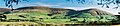
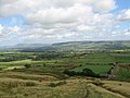
English: Parlick (also known as Parlick Pike) is a cone-shaped steep-sided hill at the extreme south of the main range of Bowland fells in Lancashire, England. Its bog-free sides make it more popular with walkers than the shallow boggy hills to its north. Paths zigzag up this hill from the south, or for the more strenuous ascent a straight path can be chosen. This hill is usually green — different from the often thorny brown to red of the northern hills. A thin neck joins Parlick onto Fair Snape Fell with well worn paths linking the two. (→Parlick)
mountain in the United Kingdom  | |||||
| Upload media | |||||
| Instance of | |||||
|---|---|---|---|---|---|
| Part of | |||||
| Location |
| ||||
| Mountain range | |||||
| Elevation above sea level |
| ||||
 | |||||
Media in category "Parlick"
The following 40 files are in this category, out of 40 total.
-
 A barn called Bradley - geograph.org.uk - 517176.jpg 640 × 426; 335 KB
-
 Across Blindhurst Fell from Parlick - geograph.org.uk - 1081962.jpg 640 × 480; 78 KB
-
 Destination Ahead - geograph.org.uk - 1126326.jpg 640 × 480; 76 KB
-
 Fair Snape Fell and Parlick 235-2.jpg 1,348 × 294; 113 KB
-
 Fairsnape to Parlick - panoramio.jpg 2,304 × 3,072; 2.45 MB
-
 FairSnapeFell.jpg 640 × 426; 115 KB
-
 Fell Foot - geograph.org.uk - 1764182.jpg 1,024 × 768; 260 KB
-
 Footpath round Parlick - geograph.org.uk - 991441.jpg 640 × 444; 101 KB
-
 In the grounds of Clitheroe Castle. - geograph.org.uk - 1650030.jpg 480 × 640; 44 KB
-
 Junction on Bleasdale Lane - geograph.org.uk - 72453.jpg 640 × 480; 89 KB
-
 Nick's Chair - geograph.org.uk - 1081979.jpg 640 × 480; 62 KB
-
 Parlick 234-34.jpg 1,259 × 665; 261 KB
-
 Parlick Fell (geograph 3344091).jpg 1,600 × 1,200; 835 KB
-
 Parlick from Fair Snape Fell 7948.jpg 640 × 480; 104 KB
-
 Parlick Grid.gif 1,000 × 1,000; 87 KB
-
 Parlick Pike - geograph.org.uk - 1624359.jpg 640 × 480; 73 KB
-
 Parlick Pike from Fairsnape Cairn - geograph.org.uk - 1065261.jpg 640 × 480; 75 KB
-
 Parlick through the arch. - geograph.org.uk - 1650210.jpg 640 × 480; 43 KB
-
 Parlick to Fairsnape - panoramio.jpg 1,600 × 1,200; 230 KB
-
 Stile, fence on Parlick - geograph.org.uk - 991448.jpg 640 × 432; 90 KB
-
 Summit Cairn, Parlick - geograph.org.uk - 542311.jpg 610 × 640; 117 KB
-
 Top of Parlick - panoramio.jpg 3,072 × 2,304; 2.97 MB
-
 Towards Fairsnape - geograph.org.uk - 1451192.jpg 640 × 480; 67 KB
-
 View from Beacon Fell.jpg 640 × 391; 41 KB
-
 View from Parlick - geograph.org.uk - 542133.jpg 640 × 480; 72 KB
-
 View from Parlick - panoramio.jpg 3,072 × 2,304; 2.9 MB
-
 Admarsh Barn Farm - geograph.org.uk - 72073.jpg 640 × 480; 83 KB
-
 Bleasdale Farmland - geograph.org.uk - 72065.jpg 640 × 480; 113 KB
-
 Blindhurst Fell and Parlick - geograph.org.uk - 359535.jpg 640 × 425; 218 KB
-
 Blindhurst Fell, Bowland - geograph.org.uk - 13055.jpg 640 × 480; 81 KB
-
 Country Road - geograph.org.uk - 122508.jpg 640 × 480; 106 KB
-
 Higher Mosserly Farm - geograph.org.uk - 122509.jpg 640 × 480; 104 KB
-
 Parlick - geograph.org.uk - 243773.jpg 640 × 480; 55 KB
-
 Parlick - geograph.org.uk - 359497.jpg 640 × 425; 218 KB
-
 Parlick - geograph.org.uk - 83788.jpg 640 × 480; 80 KB
-
 Parlick from Beacon Fell - geograph.org.uk - 370551.jpg 640 × 426; 88 KB
-
 Parlick Pike from Beacon Fell - geograph.org.uk - 111275.jpg 640 × 480; 74 KB
-
 Small Disused Quarry, Beacon Fell - geograph.org.uk - 111279.jpg 640 × 480; 161 KB
-
 The Gully, Parlick - geograph.org.uk - 13050.jpg 640 × 480; 118 KB
-
 View to Parlick Pike from Beacon Hill - geograph.org.uk - 342018.jpg 640 × 476; 48 KB


.jpg)


