Category:Peïro Plantado
| Object location | | View all coordinates using: OpenStreetMap |
|---|
|
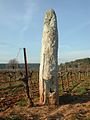
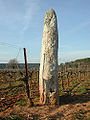
This building is classé au titre des monuments historiques de la France. It is indexed in the base Mérimée, a database of architectural heritage maintained by the French Ministry of Culture, under the reference PA00081563
|
 | |||||
| Upload media | |||||
| Instance of | |||||
|---|---|---|---|---|---|
| Location | Cabasse, canton of Besse-sur-Issole | ||||
| Street address |
| ||||
| Heritage designation |
| ||||
 | |||||
Media in category "Peïro Plantado"
The following 2 files are in this category, out of 2 total.
-
 Menhir Cabasse.jpg 1,201 × 1,600; 930 KB
-
 Peiro Plnatado.jpg 750 × 999; 233 KB
