Category:Pelourinho de Silves
| Object location | | View all coordinates using: OpenStreetMap |
|---|
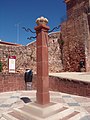
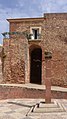
pillory in Silves, Portugal  | |||||
| Upload media | |||||
| Instance of | |||||
|---|---|---|---|---|---|
| Location | Silves, Faro, Portugal | ||||
| Heritage designation | |||||
 | |||||
|
This monument is classified as
Imóvel de Interesse Público .It is indexed in the IGESPAR database ( Instituto de Gestão do Património Arquitectónico e Arqueológico ), under the reference 74928.It is indexed in the SIPA database (Sistema de Informação para o Património Arquitectónico) under the reference 2815. |
Media in category "Pelourinho de Silves"
The following 13 files are in this category, out of 13 total.
-
 Pelourinho da cidade de Silves.jpg 3,456 × 4,608; 2.42 MB
-
 Pelourinho de Silves - Portugal (52091911746).jpg 1,365 × 2,048; 2.82 MB
-
 Pelourinho de Silves - Portugal (52121772780).jpg 1,365 × 2,048; 2.35 MB
-
 Pelourinho de Silves 2.jpg 1,816 × 4,032; 2.23 MB
-
 Pelourinho de Silves 3.jpg 1,816 × 4,032; 2.09 MB
-
 Pelourinho de Silves.jpg 1,336 × 892; 801 KB
-
 Pelourinho de Silves1.jpg 2,832 × 2,128; 533 KB
-
 Pelourinho de Silves2.jpg 2,128 × 2,832; 1.68 MB
-
 Pelourinho de Silves3.jpg 2,832 × 2,128; 590 KB
-
 Pelourinho de Silves4.jpg 2,832 × 2,128; 1.65 MB
-
 Pelourinho de Silves5.jpg 2,128 × 2,832; 1.97 MB
-
 Pelourinho em Silves, Portugal.jpg 3,456 × 4,608; 3.47 MB
-
 SilvesOctober2017 (70).jpg 2,232 × 3,968; 5.08 MB

.jpg)
.jpg)


.jpg)