Category:Pfarrkirche Dürnkrut
| Object location | | View all coordinates using: OpenStreetMap |
|---|
church building in Dürnkrut, Lower Austria  | |||||
| Upload media | |||||
| Instance of | |||||
|---|---|---|---|---|---|
| Location | Dürnkrut, Gänserndorf District, Lower Austria, Austria | ||||
| Street address |
| ||||
| Heritage designation | |||||
 | |||||
Media in category "Pfarrkirche Dürnkrut"
The following 3 files are in this category, out of 3 total.
-
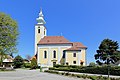 Dürnkrut - Kirche.JPG 4,302 × 2,869; 10.36 MB
-
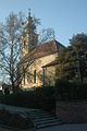 Dürnkrut kirche.jpg 500 × 752; 95 KB
-
 Dürnkrut-Kirche-01.jpg 2,000 × 1,486; 1.01 MB

