Category:Pfarrkirche Hüttschlag
| Object location | | View all coordinates using: OpenStreetMap |
|---|
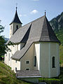
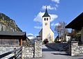
church building in Hüttschlag, Austria   | |||||
| Upload media | |||||
| Instance of | |||||
|---|---|---|---|---|---|
| Location | Hüttschlag, Sankt Johann im Pongau District, Salzburg, Austria | ||||
| Heritage designation | |||||
 | |||||
Media in category "Pfarrkirche Hüttschlag"
The following 9 files are in this category, out of 9 total.
-
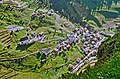 1965-07-Huettschlag-Austria.jpg 2,500 × 1,641; 1.53 MB
-
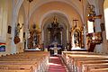 Hüttschlag - Hl. Josep, innen.JPG 3,640 × 2,420; 4.29 MB
-
 Hüttschlag Mai 2005.jpg 800 × 601; 113 KB
-
 Kath. Pfarrkirche hl. Josef Hüttschlag 003.jpg 3,168 × 4,752; 6.04 MB
-
 Kath. Pfarrkirche hl. Josef Hüttschlag 089.jpg 4,752 × 3,168; 8.78 MB
-
 Kirche-Hüttschlag1.jpg 1,360 × 1,813; 477 KB
-
 Kirchet-Hüttschlag2.jpg 2,048 × 1,360; 515 KB
-
 Pfarrhaus-Hüttschlag.jpg 1,858 × 1,239; 346 KB
-
 Pfarrkirche von Hüttschlag - Hl. Joseph, außen.jpg 3,730 × 2,650; 5.79 MB


