Category:Pfarrkirche Pregarten
| Object location | | View all coordinates using: OpenStreetMap |
|---|
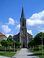
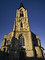
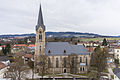
church building in Pregarten, Austria  | |||||
| Upload media | |||||
| Instance of | |||||
|---|---|---|---|---|---|
| Location | Pregarten, Freistadt District, Upper Austria, Austria | ||||
| Street address |
| ||||
| Heritage designation | |||||
 | |||||
Media in category "Pfarrkirche Pregarten"
The following 9 files are in this category, out of 9 total.
-
 20230204-bücherzelle-fürstplatz-pfarrkirche-pregarten.jpg 2,954 × 3,997; 7.73 MB
-
 Pregarten 2022-06-26 Pfarrkirche - Bild 01.jpg 4,608 × 3,456; 5.34 MB
-
 Pregarten 2022-06-26 Pfarrkirche - Bild 02.jpg 3,456 × 4,608; 6.71 MB
-
 Pregarten 2022-06-26 Pfarrkirche - Bild 03.jpg 4,608 × 3,456; 6.38 MB
-
 Pregarten 2022-06-26 Pfarrkirche - Bild 04.jpg 3,456 × 4,608; 6.7 MB
-
 Pregarten Kirche.jpg 1,200 × 1,600; 288 KB
-
 Pregarten Stadtpfarrkirche St. Anna.JPG 3,872 × 2,592; 5.56 MB
-
 Sanktanna.JPG 593 × 785; 137 KB
-
 Stadtpfarrkirche St. Anna (Südansicht).jpg 2,048 × 1,365; 1.87 MB


.jpg)