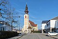
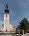
Category:Pfarrkirche hl. Martin, Gunskirchen
| Object location | | View all coordinates using: OpenStreetMap |
|---|
church building in Gunskirchen, Upper Austria   | |||||
| Upload media | |||||
| Instance of | |||||
|---|---|---|---|---|---|
| Named after | |||||
| Location | Gunskirchen, Wels-Land District, Upper Austria, Austria | ||||
| Street address |
| ||||
| Diocese | |||||
| Heritage designation | |||||
| Religion or worldview | |||||
| official website | |||||
 | |||||
| This category shows the protected monument with the number 58507 in Austria. (Commons, de, Wikidata) |
Deutsch: Kath. Pfarrkirche hl. Martin mit Friedhof
Media in category "Pfarrkirche hl. Martin, Gunskirchen"
The following 7 files are in this category, out of 7 total.
-
 Gunskirchen - Kirche.JPG 2,757 × 3,900; 9.15 MB
-
 Gunskirchen Friedhof Portal.jpg 5,530 × 3,687; 5.99 MB
-
 Gunskirchen Friedhof Tafel Johann Stifter.jpg 5,955 × 3,970; 10.46 MB
-
 Gunskirchen kath Pfarrkirche hl Martin.jpg 5,551 × 3,701; 5.7 MB
-
 Gunskirchen Pfarrkirche hl Martin.jpg 3,620 × 5,430; 4.85 MB
-
 Gunskirchen, die Katholische Pfarrkirche heilige Martin Dm58507 foto4 2017-08-10 14.01.jpg 2,894 × 3,522; 5.08 MB
-
 Pfarrkirche Gunskirchen.jpg 3,648 × 2,736; 3.72 MB


