Category:Pierre Lormée
| Object location | | View all coordinates using: OpenStreetMap |
|---|
| Upload media | |||||
| Instance of | |||||
|---|---|---|---|---|---|
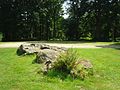
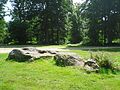
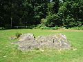
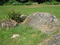
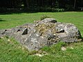
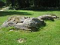
| Location | Broglie, canton of Broglie | ||||
 | |||||
Media in category "Pierre Lormée"
The following 12 files are in this category, out of 12 total.
-
 Menhir de la pierre Lormée Broglie.JPG 3,648 × 2,736; 3.9 MB
-
 Pierre Lormée Broglie 1.jpg 3,648 × 2,736; 3.95 MB
-
 Pierre Lormée Broglie 2.jpg 3,648 × 2,736; 3.92 MB
-
 Pierre Lormée Broglie 3.jpg 3,648 × 2,736; 4.07 MB
-
 Pierre Lormée Broglie 4.jpg 3,648 × 2,736; 3.98 MB
-
 Pierre Lormée Broglie 5.jpg 3,648 × 2,736; 3.98 MB
-
 Pierre Lormée Broglie 6.jpg 3,648 × 2,736; 4.01 MB
-
 Pierre Lormée Broglie 7.jpg 3,648 × 2,736; 4.08 MB
-
 Pierre Lormée Broglie 8.jpg 3,648 × 2,736; 4.07 MB
-
 Pierre Lormée Broglie 9.jpg 3,648 × 2,736; 4.03 MB
-
 Pierre Lormée Broglie inscriptions 1.jpg 2,736 × 3,648; 3.42 MB
-
 Pierre Lormée Broglie inscriptions 2.jpg 557 × 744; 136 KB


