Category:Pigeon Point Lighthouse
| Object location | | View all coordinates using: OpenStreetMap |
|---|
|
This is a category about a place or building that is listed on the National Register of Historic Places in the United States of America. Its reference number is 77000337. |
|
This is a category about a place or building that is listed on the California Historical Landmark listing in the United States. Its reference number is 930.
|
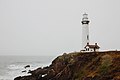
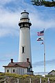
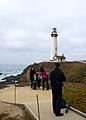
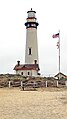
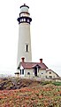
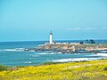
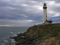
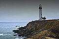
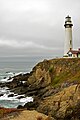
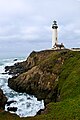
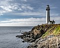
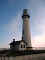
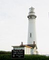
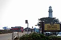
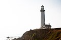
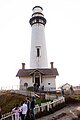
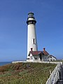
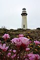
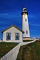
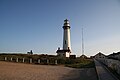
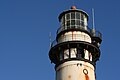
English: Pigeon Point Lighthouse, built in 1871, is the tallest lighthouse (tied with Point Arena Light) on the West Coast of the United States. Located on the coastal highway (State Route 1), 5 miles (8 km) south of Pescadero, California, between Santa Cruz and San Francisco in San Mateo County.
lighthouse in California, United States .jpg)  .png) | |||||
| Upload media | |||||
| Instance of | |||||
|---|---|---|---|---|---|
| Made from material | |||||
| Location | San Mateo County, California, Pacific States Region | ||||
| Located in or next to body of water | |||||
| Heritage designation | |||||
| Service entry |
| ||||
| Height |
| ||||
 | |||||
Subcategories
This category has the following 5 subcategories, out of 5 total.
Media in category "Pigeon Point Lighthouse"
The following 146 files are in this category, out of 146 total.
-
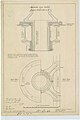 Adjustable Lens Socket - NARA - 77415884.jpg 4,112 × 6,184; 6.16 MB
-
 Aerial View of Pigeon Point lighthouse and surrounding coastline.JPG 4,384 × 2,466; 3.35 MB
-
 Again.. (208723250).jpg 3,456 × 2,304; 2.08 MB
-
 Along San Mateo Coast (21377287488).jpg 2,048 × 1,536; 2.06 MB
-
 Andrew Charney 2017-02-12 (Unsplash).jpg 5,760 × 3,840; 11.22 MB
-
 Arriving at pigeon point hostel (208721483).jpg 3,456 × 2,304; 2.33 MB
-
 Bay Area (22767897017).jpg 6,016 × 3,210; 9.22 MB
-
 Bay Area (22866273450).jpg 6,016 × 4,000; 10.97 MB
-
 Bay Area (22866304210).jpg 6,016 × 4,000; 22.15 MB
-
 Bay Area (23162116565).jpg 6,016 × 4,000; 21.03 MB
-
 Be prepared, i took a lot of pics of this lighthouse (208722656).jpg 2,304 × 3,456; 2.43 MB
-
 Bikes at the lighthouse (1685130204).jpg 2,304 × 3,072; 3.29 MB
-
 Bird above fog horn (2862256946).jpg 2,560 × 1,920; 1.41 MB
-
 Body (3872745885).jpg 3,888 × 2,592; 2.54 MB
-
 California lighthouse (Unsplash).jpg 4,608 × 3,456; 8.69 MB
-
 California Trip - June 2016 - Pigeon Point Lighthouse (28528076563).jpg 3,849 × 5,773; 10.94 MB
-
 California Trip - June 2016 - Pigeon Point Lighthouse (28528082773).jpg 4,309 × 2,873; 8.83 MB
-
 California Trip - June 2016 - Pigeon Point Lighthouse (29041196042).jpg 4,000 × 6,000; 17.22 MB
-
 California Trip - June 2016 - Pigeon Point Lighthouse (29069174851).jpg 2,984 × 4,476; 6.22 MB
-
 California Trip - June 2016 - Pigeon Point Lighthouse (29113799306).jpg 3,767 × 5,651; 14.47 MB
-
 California Trip - June 2016 - Pigeon Point Lighthouse (29113806216).jpg 3,214 × 4,821; 12.27 MB
-
 California Trip - June 2016 - Pigeon Point Lighthouse (29146793765).jpg 3,630 × 5,445; 9.14 MB
-
 DSC 0374 (12386349965).jpg 2,848 × 4,288; 2.3 MB
-
 Family taking photos at Pigeon Point Lighthouse (5050472858).jpg 2,395 × 3,354; 1.62 MB
-
 Flags (5519210182).jpg 5,184 × 3,456; 1.02 MB
-
 Foamy Seas at Pigeon Point Lighthouse (4729859185).jpg 4,185 × 2,759; 4.44 MB
-
 Keeper's house (5259652499).jpg 795 × 1,200; 316 KB
-
 Lighthouse (15807773815).jpg 1,152 × 864; 681 KB
-
 Lighthouse California-06697 - Pigeon Point Lighthouse (21740183371).jpg 1,080 × 1,920; 1.36 MB
-
 Lighthouse California-06698 - Pigeon Point Lighthouse (21704762586).jpg 1,114 × 1,939; 1.29 MB
-
 Lighthouse California-06699 - Pigeon Point Lighthouse (21704764556).jpg 1,130 × 1,948; 1.37 MB
-
 Lighthouse California-06714 - Pigeon Point Lighthouse (21543008048).jpg 1,080 × 1,920; 1.06 MB
-
 Lighthouse California-06716 - Pigeon Point Lighthouse (21109830133).jpg 1,080 × 1,920; 1.14 MB
-
 Lighthouse California-06721 - Pigeon Point Lighthouse (21108154394).jpg 1,080 × 1,920; 1.26 MB
-
 Lighthouse California-06722 - Pigeon Point Lighthouse (21740196451).jpg 1,130 × 1,948; 1.03 MB
-
 Lighthouse DSC07429 (2862245214).jpg 1,920 × 2,560; 1.19 MB
-
 Lighthouse DSC07433 (2861424969).jpg 2,560 × 1,920; 1.38 MB
-
 Lighthouse IMG 3028 (38140264266).jpg 1,080 × 1,620; 466 KB
-
 LighthouseCalifornia.JPG 3,072 × 2,304; 645 KB
-
 LighthousePigeonPointCA.jpg 1,428 × 2,226; 341 KB
-
 Line3107 - Flickr - NOAA Photo Library.jpg 1,632 × 2,448; 1.52 MB
-
 Line3110 - Flickr - NOAA Photo Library.jpg 2,448 × 1,632; 1.72 MB
-
 Map of Lighthouse Lands, Pigeon Point - NARA - 77415848.jpg 8,164 × 8,005; 15.12 MB
-
 P2234936 1a2brds (12870064743).jpg 900 × 1,100; 894 KB
-
 Pidgeon Point (23420175674).jpg 1,344 × 2,048; 122 KB
-
 Pidgeon point lighthouse.PNG 864 × 1,152; 1.16 MB
-
 Pigeon point hostel (1684359381).jpg 3,072 × 2,304; 3.38 MB
-
 Pigeon Point Light House - panoramio.jpg 1,200 × 900; 214 KB
-
 Pigeon Point light house.jpg 3,456 × 5,184; 4.13 MB
-
 Pigeon Point Light Station (3904208).jpg 1,200 × 1,600; 98 KB
-
 Pigeon Point Light Station 4.jpg 2,592 × 3,872; 4.69 MB
-
 Pigeon Point Light Station from Afar.jpg 2,832 × 2,128; 1.29 MB
-
 Pigeon Point Light Station.jpg 2,541 × 1,881; 1 MB
-
 Pigeon Point Light Tower, California.jpg 2,988 × 5,312; 5.64 MB
-
 Pigeon point lighthouse (1685375634).jpg 3,072 × 2,304; 3.26 MB
-
 Pigeon Point Lighthouse (2016) upright.jpg 3,117 × 4,701; 7.58 MB
-
 Pigeon Point Lighthouse (2016).jpg 4,843 × 3,217; 14 MB
-
 Pigeon Point lighthouse (2861418445).jpg 1,920 × 2,560; 707 KB
-
 Pigeon Point lighthouse (2862251470).jpg 1,920 × 2,560; 1.63 MB
-
 Pigeon Point Lighthouse (2881507532).jpg 3,008 × 2,000; 919 KB
-
 Pigeon Point Lighthouse (3878008723).jpg 2,500 × 1,683; 2.98 MB
-
 Pigeon Point Lighthouse (3878009117).jpg 1,501 × 2,500; 1.34 MB
-
 Pigeon Point Lighthouse (3878802824).jpg 2,500 × 1,713; 2.13 MB
-
 Pigeon Point Lighthouse (3972691937).jpg 3,635 × 2,150; 959 KB
-
 Pigeon Point Lighthouse (4729858799).jpg 2,759 × 4,198; 4.95 MB
-
 Pigeon Point Lighthouse (4729860655).jpg 2,755 × 4,206; 4.74 MB
-
 Pigeon Point Lighthouse (4729862643).jpg 4,214 × 2,746; 5.49 MB
-
 Pigeon Point Lighthouse (4729871625).jpg 2,767 × 4,214; 5.41 MB
-
 Pigeon Point Lighthouse (4965597827).jpg 2,592 × 3,888; 3.25 MB
-
 Pigeon Point Lighthouse (5049853099).jpg 2,848 × 4,288; 3.84 MB
-
 Pigeon Point Lighthouse (5049854459).jpg 4,288 × 2,848; 3.28 MB
-
 Pigeon Point Lighthouse (5063342918).jpg 2,160 × 2,880; 676 KB
-
 Pigeon Point Lighthouse (5063343210).jpg 2,880 × 2,160; 962 KB
-
 Pigeon Point Lighthouse (5165732145).jpg 500 × 752; 161 KB
-
 Pigeon Point Lighthouse - Jan 4 2016.jpg 960 × 1,280; 244 KB
-
 Pigeon Point Lighthouse 05-03-2010.jpg 2,222 × 1,883; 4.11 MB
-
 Pigeon Point Lighthouse 1.jpg 2,448 × 3,264; 3 MB
-
 Pigeon Point Lighthouse 11-23-21 - Explored - Flickr - Sharon Mollerus.jpg 5,049 × 4,039; 13.72 MB
-
 Pigeon Point Lighthouse 2 .jpg 3,000 × 1,859; 6.33 MB
-
 Pigeon Point Lighthouse 2.jpg 2,448 × 3,264; 3.22 MB
-
 Pigeon Point Lighthouse 2016 (31086568313).jpg 4,843 × 3,217; 12.19 MB
-
 Pigeon Point Lighthouse and tide pools 2.jpg 2,145 × 2,000; 2.99 MB
-
 Pigeon Point Lighthouse and wildflowers.jpg 1,776 × 1,777; 3.34 MB
-
 Pigeon Point Lighthouse at Moonset.jpg 3,435 × 4,000; 2.5 MB
-
 Pigeon Point Lighthouse Blue Sky.jpg 5,184 × 3,456; 8.23 MB
-
 Pigeon Point Lighthouse CA - from distance.jpg 5,979 × 3,986; 2.22 MB
-
 Pigeon Point Lighthouse California NRHP 77000337a.jpg 3,000 × 4,000; 5.25 MB
-
 Pigeon Point Lighthouse California NRHP 77000337b.jpg 3,000 × 4,000; 5.86 MB
-
 Pigeon Point Lighthouse California NRHP 77000337c.jpg 4,000 × 3,000; 4.07 MB
-
 Pigeon Point Lighthouse California NRHP 77000337e.jpg 4,000 × 3,000; 4.89 MB
-
 Pigeon Point Lighthouse circa 1950.jpg 3,845 × 2,569; 4.27 MB
-
 Pigeon Point Lighthouse for infobox.jpg 640 × 425; 32 KB
-
 Pigeon Point Lighthouse from northeast.jpg 5,184 × 3,456; 6.08 MB
-
 Pigeon Point Lighthouse In 2016 (190115861).jpeg 2,048 × 1,365; 1.13 MB
-
 Pigeon Point Lighthouse in California.jpg 1,740 × 2,610; 1.52 MB
-
 Pigeon Point Lighthouse on the California Coast. Overcast Day..jpg 819 × 1,024; 333 KB
-
 Pigeon Point Lighthouse viewed from Franklin Point (49296162581).jpg 5,664 × 3,540; 7.94 MB
-
 Pigeon Point Lighthouse, CA 1, Pescadero, CA 10-30-2011 2-54-06 PM.JPG 3,072 × 2,304; 916 KB
-
 Pigeon Point Lighthouse, CA 1, Pescadero, CA 10-30-2011 2-59-26 PM.JPG 2,304 × 3,072; 1.33 MB
-
 Pigeon Point Lighthouse, CA 1, Pescadero, CA 10-30-2011 3-15-03 PM.JPG 3,072 × 2,304; 1.37 MB
-
 Pigeon Point Lighthouse, CA 1, Pescadero, CA 10-30-2011 3-19-12 PM.JPG 2,304 × 3,072; 1.13 MB
-
 Pigeon Point Lighthouse, CA USA - panoramio (4).jpg 2,851 × 1,900; 1.23 MB
-
 Pigeon Point Lighthouse, California (14867719604).jpg 4,752 × 3,168; 12.09 MB
-
 Pigeon Point Lighthouse, California (95666089).jpg 1,125 × 1,600; 157 KB
-
 Pigeon Point Lighthouse, California (95666113).jpg 1,305 × 1,600; 119 KB
-
 Pigeon Point Lighthouse.jpg 3,000 × 4,000; 3.27 MB
-
 Pigeon point lighthouse.jpg 1,751 × 2,633; 1.69 MB
-
 Pigeon Point Lighthouse.png 1,370 × 1,048; 2.06 MB
-
 Pigeon Point PIC 0525 (45940432721).jpg 3,888 × 2,592; 3.27 MB
-
 Pigeon Point PIC 0535 (32069201038).jpg 3,597 × 2,398; 3.26 MB
-
 Pigeon Point PIC 0544 (45940429871).jpg 3,435 × 2,290; 3.18 MB
-
 Pigeon Point PIC 0547 (32069199698).jpg 2,788 × 1,859; 1.5 MB
-
 Pigeon Point PIC 0556 (45940429151).jpg 2,592 × 3,888; 4.77 MB
-
 Pigeon Point PIC 0561 (32069198348).jpg 3,357 × 2,238; 3.08 MB
-
 Pigeon Point PIC 0570 (45940428071).jpg 3,888 × 2,592; 6.38 MB
-
 Pigeon Point PIC 0581 (45940426331).jpg 3,888 × 2,592; 5.37 MB
-
 Pigeon Point PIC 0610 (45940421611).jpg 2,592 × 3,888; 6 MB
-
 Pigeon Point PIC 0616 (44124140970).jpg 3,888 × 2,592; 7.19 MB
-
 Pigeon Point PIC 0619 (31001645917).jpg 2,486 × 3,729; 4.51 MB
-
 Pigeon Point, California, barrel.jpg 2,988 × 5,312; 6.21 MB
-
 Pigeon point.jpg 3,648 × 2,736; 1.78 MB
-
 PigeonPoint.jpg 3,000 × 2,500; 972 KB
-
 PigeonPointLighthouse 097.jpg 1,580 × 2,121; 187 KB
-
 PigeonPointLighthouse 4697.JPG 3,840 × 2,160; 2.79 MB
-
 PigeonPointLighthouse 4706.JPG 3,840 × 2,160; 3.41 MB
-
 PigeonPointLighthouse.jpg 1,944 × 2,592; 1.16 MB
-
 Pink Flowers, Pigeon Point Light Station State Historic Park (7654619180).jpg 2,848 × 4,272; 3.12 MB
-
 Power lines (50374130662).jpg 5,118 × 2,879; 3.26 MB
-
 Power lines at Pigeon Point (49296160181).jpg 5,116 × 3,411; 2.82 MB
-
 PPLightouse.JPG 3,072 × 2,304; 632 KB
-
 Road to the lighthouse (50373970411).jpg 3,866 × 3,866; 3.98 MB
-
 Sag at the lighhouse (1684512301).jpg 2,304 × 3,072; 3.24 MB
-
 Sag wagon (1684501889).jpg 2,304 × 3,072; 3.38 MB
-
 Santa Cruz Lighthouse - panoramio - UncleVinny.jpg 900 × 720; 61 KB
-
 Scenic Simplicity (16068838461).jpg 992 × 1,448; 1.65 MB
-
 Sunny Pigeon Point (4321266418).jpg 2,584 × 3,887; 9.78 MB
-
 The lighthouse (208722078).jpg 3,456 × 2,304; 2.45 MB
-
 The lighthouse (208725199).jpg 3,456 × 2,304; 2.21 MB
-
 The lighthouse and the bikes (208755535).jpg 2,304 × 3,456; 2.85 MB
-
 The Point (5519211094).jpg 5,184 × 3,456; 1.92 MB
-
 The Top (3873542408).jpg 3,888 × 2,592; 2.07 MB
-
 Vicinity of Pigeon Point Lighthouse.jpg 2,461 × 4,682; 9.74 MB
-
 We made it to pigeon point (1685110566).jpg 3,072 × 2,304; 3.33 MB
-
 Window (5570732770).jpg 5,184 × 3,456; 1.7 MB
-
 Yellow (5518618415).jpg 5,184 × 2,777; 2.19 MB
-
 Yup, the lighthouse (208723989).jpg 2,304 × 3,456; 2.27 MB


.jpg)
.jpg)
.jpg)
.jpg)
.jpg)
.jpg)
.jpg)
.jpg)
.jpg)
.jpg)
.jpg)
.jpg)
.jpg)
.jpg)
.jpg)
.jpg)
.jpg)
.jpg)
.jpg)
.jpg)
.jpg)
.jpg)
.jpg)
.jpg)
.jpg)
.jpg)
.jpg)
.jpg)
.jpg)
.jpg)
.jpg)
.jpg)
.jpg)
.jpg)
.jpg)
.jpg)


.jpg)
.jpg)

.jpg)


.jpg)


.jpg)
_upright.jpg)
.jpg)
.jpg)
.jpg)
.jpg)
.jpg)
.jpg)
.jpg)
.jpg)
.jpg)
.jpg)
.jpg)
.jpg)
.jpg)
.jpg)
.jpg)
.jpg)
.jpg)


.jpg)


.jpeg)


.jpg)


.jpg)
.jpg)
.jpg)
.jpg)


.jpg)
.jpg)
.jpg)
.jpg)
.jpg)
.jpg)
.jpg)
.jpg)
.jpg)
.jpg)
.jpg)


.jpg)
.jpg)
.jpg)

.jpg)
.jpg)
.jpg)

.jpg)
.jpg)
.jpg)
.jpg)
.jpg)
.jpg)
.jpg)

.jpg)
.jpg)
.jpg)
.jpg)