Category:Pollenfeld
municipality of Germany    | |||||
| Upload media | |||||
| Instance of |
| ||||
|---|---|---|---|---|---|
| Part of |
| ||||
| Location | Eichstätt, Upper Bavaria, Bavaria, Germany | ||||
| Head of government |
| ||||
| Population |
| ||||
| Area |
| ||||
| Elevation above sea level |
| ||||
| official website | |||||
 | |||||
Subcategories
This category has the following 5 subcategories, out of 5 total.
B
M
S
Media in category "Pollenfeld"
The following 16 files are in this category, out of 16 total.
-
 DEU Pollenfeld COA.svg 512 × 563; 80 KB
-
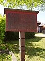 Grenzschild Wörmersdorf.JPG 1,920 × 2,560; 1.02 MB
-
 Kirchenfenster Pollenfeld.jpg 2,336 × 3,504; 4 MB
-
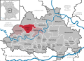
 Pollenfeld - Lage im Landkreis.png 281 × 185; 32 KB
-
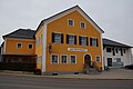 Pollenfeld EI 001.jpg 6,000 × 4,000; 5.59 MB
-
 Pollenfeld EI 002.jpg 6,000 × 4,000; 8.84 MB
-
 Pollenfeld im Landkreis Eichstätt.jpg 2,044 × 678; 96 KB
-
 Pollenfeld in EI.svg 804 × 580; 1.12 MB
-
 Pollenfeld von oben. In Bildmitte die Kirche St. Sixtus.jpg 14,400 × 6,004; 43.92 MB
-
 St. Sixtus - Pollenfeld 121.jpg 6,000 × 4,000; 8.17 MB
-
 St. Sixtus - Pollenfeld 122.jpg 6,000 × 4,000; 7.75 MB
-
 St. Sixtus - Pollenfeld 123.jpg 4,000 × 6,000; 4.18 MB
-
 St. Sixtus - Pollenfeld 127.jpg 6,000 × 4,000; 7.17 MB
-
 Wappen von Pollenfeld.png 268 × 292; 25 KB
-
 Windräder Pollenfeld -2017-10.jpg 2,048 × 1,536; 1.01 MB
-
 Windräder, Nähe Pollenfeld.jpg 2,000 × 1,127; 551 KB


