Category:Population density maps of India
Countries of Asia: Bangladesh · People's Republic of China · Cyprus‡ · India · Indonesia‡ · Iran · Israel · Japan · Kazakhstan‡ · Malaysia · Nepal · Pakistan · Philippines · Russia‡ · Saudi Arabia · South Korea · Syria · Turkey‡
Limited recognition: Taiwan
‡: partly located in Asia
Limited recognition: Taiwan
‡: partly located in Asia
Subcategories
This category has the following 2 subcategories, out of 2 total.
A
K
- Demographic maps of Kerala (7 F)
Media in category "Population density maps of India"
The following 22 files are in this category, out of 22 total.
-
 2011 Census India population density map, states and union territories.svg 1,578 × 1,738; 863 KB
-
 78 of '(Longmans' Junior School Geography, etc.)' (11209721444).jpg 2,056 × 2,705; 1.39 MB
-
 Bevölkerungsdichte Indien.png 1,000 × 1,138; 123 KB
-
 Bevölkerungsdichte Indiens.png 604 × 700; 37 KB
-
 Cities in India East.png 1,344 × 743; 66 KB
-
 Cities in India South.png 1,344 × 743; 56 KB
-
 Cities in India West.png 1,344 × 743; 67 KB
-
 Distribution of Christians in Indian states.JPG 906 × 1,053; 68 KB
-
 Image taken from page 78 of 'Longmans' Junior School Geography, etc' (11196209185).jpg 2,107 × 2,753; 1.26 MB
-
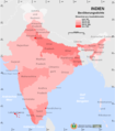
 India population density map en.svg 1,639 × 1,852; 1.23 MB
-
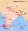 India population density map es.svg 1,540 × 1,740; 1.41 MB
-
 India population density map he.svg 1,639 × 1,852; 1.32 MB
-
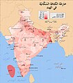 India population density map-ar.jpg 1,639 × 1,852; 547 KB
-
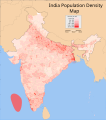 India population density map.svg 1,639 × 1,852; 801 KB
-
 India Population Density, 2000 (5457621354).jpg 2,507 × 3,265; 800 KB
-
 India Population Density, 2000 (6171910727).jpg 2,342 × 2,879; 802 KB
-
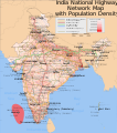 India roadway map with population density.svg 1,639 × 1,852; 1.4 MB
-
 Population density impgazind1909.jpg 1,462 × 1,205; 491 KB
-
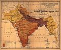
 Population density map of British India according to 1911 Census.jpg 2,976 × 2,544; 7.09 MB
-
 Population Density Map.jpg 11,692 × 8,267; 2.54 MB
-
 Population density of India states and union territories.png 3,349 × 3,902; 668 KB
-
 Uttar Pradesh population density 2011.svg 800 × 750; 611 KB

%27_(11209721444).jpg)


.jpg)


.jpg)
.jpg)


