Home
Random
Nearby
Log in
Settings
Donate
About Wikimedia Commons
Disclaimers
Search
Category
:
Potomac Aqueduct (HAER drawings)
Language
Watch
Edit
Media in category "Potomac Aqueduct (HAER drawings)"
The following 17 files are in this category, out of 17 total.
CIRCULAR COFFERDAM CONSTRUCTED FOR PIER 1 - Potomac Aqueduct, Spanning Potomac River, Washington, District of Columbia, DC HAER DC,GEO,1-4.tif
4,891 × 3,925; 18.31 MB
Fence Detail (1868 Portion); Fence Detail (1888 Portion) - Potomac Aqueduct, Spanning Potomac River, Washington, District of Columbia, DC HAER DC,GEO,1- (sheet 4 of 4).png
9,646 × 7,616; 2.11 MB
Fence Detail (1868 Portion); Fence Detail (1888 Portion) - Potomac Aqueduct, Spanning Potomac River, Washington, District of Columbia, DC HAER DC,GEO,1- (sheet 4 of 4).tif
9,646 × 7,616; 486 KB
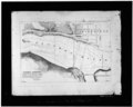
HYDROGRAPHIC SURVEY OF THE POTOMAC RIVER NEAR GEORGETOWN - Potomac Aqueduct, Spanning Potomac River, Washington, District of Columbia, DC HAER DC,GEO,1-1.tif
4,890 × 3,913; 18.25 MB
ITHIEL TOWN'S DESIGN FOR THE POTOMAC AQUEDUCT (see HABS No. DC-166 for a nearly identical version of this view) - Potomac Aqueduct, Spanning Potomac River, Washington, District of HAER DC,GEO,1-2.tif
4,896 × 3,913; 18.27 MB
OPERATION OF THE DERRICKS HOISTING AND LOWERING STONE AT COFFERDAM NO. 1 - Potomac Aqueduct, Spanning Potomac River, Washington, District of Columbia, DC HAER DC,GEO,1-8.tif
4,425 × 3,534; 14.92 MB
PERSPECTIVE OF THE BOOMS, SHOWING THE MANNER IN WHICH STONE WAS HOISTED UPON THE PIER AFTER REMOVAL OF THE DERRICKS. - Potomac Aqueduct, Spanning Potomac River, Washington, District of HAER DC,GEO,1-9.tif
4,628 × 3,693; 16.3 MB
PERSPECTIVE OF THE PUMPING AND DREDGING MACHINERY - Potomac Aqueduct, Spanning Potomac River, Washington, District of Columbia, DC HAER DC,GEO,1-7.tif
4,901 × 3,941; 18.42 MB
PERSPECTIVE OF THE PUMPING MACHINERY FOR THE ABUUTMENT COFFERDAM - Potomac Aqueduct, Spanning Potomac River, Washington, District of Columbia, DC HAER DC,GEO,1-6.tif
4,846 × 3,875; 17.91 MB
Plan - Potomac Aqueduct, Spanning Potomac River, Washington, District of Columbia, DC HAER DC,GEO,1- (sheet 2 of 4).png
9,658 × 7,616; 2.58 MB
Plan - Potomac Aqueduct, Spanning Potomac River, Washington, District of Columbia, DC HAER DC,GEO,1- (sheet 2 of 4).tif
9,658 × 7,616; 670 KB
PLAN AND SECTION OF COFFERDAM FOR PIER 2 - Potomac Aqueduct, Spanning Potomac River, Washington, District of Columbia, DC HAER DC,GEO,1-5.tif
4,906 × 3,930; 18.39 MB
Potomac Aqueduct Title Page - Potomac Aqueduct, Spanning Potomac River, Washington, District of Columbia, DC HAER DC,GEO,1- (sheet 1 of 4).png
9,626 × 7,616; 2.68 MB
Potomac Aqueduct Title Page - Potomac Aqueduct, Spanning Potomac River, Washington, District of Columbia, DC HAER DC,GEO,1- (sheet 1 of 4).tif
9,626 × 7,616; 774 KB
STEAM ENGINE USED IN DREDGING AND PUMPING OUT COFFERDAM - Potomac Aqueduct, Spanning Potomac River, Washington, District of Columbia, DC HAER DC,GEO,1-3.tif
4,907 × 3,962; 18.54 MB
West Elevation, South Elevation - Potomac Aqueduct, Spanning Potomac River, Washington, District of Columbia, DC HAER DC,GEO,1- (sheet 3 of 4).png
9,616 × 7,616; 3.2 MB
West Elevation, South Elevation - Potomac Aqueduct, Spanning Potomac River, Washington, District of Columbia, DC HAER DC,GEO,1- (sheet 3 of 4).tif
9,616 × 7,616; 1.02 MB

;_Fence_Detail_(1888_Portion)_-_Potomac_Aqueduct,_Spanning_Potomac_River,_Washington,_District_of_Columbia,_DC_HAER_DC,GEO,1-_(sheet_4_of_4).png)


.png)


.png)


.png)
