Category:Princes Street tram stop
| Object location | | View all coordinates using: OpenStreetMap |
|---|
tram stop in City of Edinburgh, Scotland, UK  | |||||
| Upload media | |||||
| Instance of | |||||
|---|---|---|---|---|---|
| Location | Edinburgh, City of Edinburgh, Scotland | ||||
| Transport network | |||||
| Connecting line |
| ||||
| Adjacent station |
| ||||
 | |||||
Media in category "Princes Street tram stop"
The following 31 files are in this category, out of 31 total.
-
 A tram-stop shelter under construction in Princes Street (geograph 3507396).jpg 3,648 × 2,736; 1.85 MB
-
 Bus and tram on Princes Street (geograph 3863744).jpg 3,264 × 2,448; 4.09 MB
-
 Edinburgh - August 2015 (10) (20672537521).jpg 4,608 × 3,072; 5.4 MB
-
 Edinburgh 2013 (10140931393).jpg 1,170 × 1,280; 701 KB
-
 Edinburgh IMG 3916 (14919003542).jpg 4,608 × 3,456; 3.95 MB
-
 Edinburgh tram 04.JPG 2,952 × 1,992; 1.02 MB
-
 Edinburgh tram on Princes Street (geograph 3863640).jpg 3,264 × 2,448; 3.6 MB
-
 Edinburgh tram, Princes Street, 13 September 2014.jpg 3,456 × 2,304; 4.84 MB
-
 EDTRAM1.jpg 2,048 × 1,536; 808 KB
-
 Lothian buses & trams (13134285914).jpg 5,184 × 2,920; 6.2 MB
-
 Map of Princes Street tram stop (OSM standard, zoom 16).jpg 522 × 437; 60 KB
-
 Map of Princes Street tram stop (OSM standard, zoom 17).jpg 515 × 417; 52 KB
-
 Map of Princes Street tram stop (OSM standard, zoom 18).jpg 523 × 421; 33 KB
-
 New Club, 86 Princes Street, Edinburgh (geograph 3503984).jpg 1,749 × 1,368; 586 KB
-
 Not long to wait now - about 10 months? (geograph 3586881).jpg 3,264 × 2,448; 3.53 MB
-
 Princes St (geograph 2286891).jpg 640 × 430; 60 KB
-
 Princes Street (geograph 2582710).jpg 382 × 640; 115 KB
-
 Princes Street from Castle Street (geograph 2696100).jpg 3,264 × 2,448; 3.62 MB
-
 Princes Street Tram Station, Edinburgh - geograph.org.uk - 4608167.jpg 1,024 × 681; 164 KB
-
 Princes Street tram stop (12138080364) (2).jpg 4,608 × 3,072; 4.69 MB
-
 Princes Street tram stop (geograph 4200724).jpg 1,200 × 788; 204 KB
-
 Princes Street tram stop, 21 September 2012.jpg 1,024 × 768; 488 KB
-
 Princes Street tram stop, Edinburgh.jpg 3,264 × 2,448; 4.14 MB
-
 Princes Street, looking west (geograph 4054395).jpg 3,264 × 2,448; 3.9 MB
-
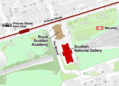 Scottish National Gallery map Edinburgh.png 743 × 535; 118 KB
-
 The tram (14367615869).jpg 2,048 × 1,536; 987 KB
-
 Tram 267 on Princes Street (geograph 4200744).jpg 1,200 × 784; 198 KB
-
 Tram in Princes Street, Edinburgh (geograph 4070020).jpg 1,024 × 762; 217 KB
-
 Tram stop on Princes Street (geograph 3586863).jpg 3,264 × 2,448; 3.59 MB
-
 Tram stop, Princes Street (geograph 3496800).jpg 3,264 × 2,448; 2.84 MB
-
 Trams - at any time (geograph 3222461).jpg 3,264 × 2,448; 3.29 MB
.jpg)
.jpg)
_(20672537521).jpg)
.jpg)
.jpg)

.jpg)


.jpg)
.jpg)
.jpg)
.jpg)
.jpg)
.jpg)
.jpg)
.jpg)
.jpg)

_(2).jpg)
.jpg)

.jpg)

.jpg)
.jpg)
.jpg)
.jpg)
.jpg)
.jpg)