Category:Protestantse Kerk (Ritthem)
| Object location | | View all coordinates using: OpenStreetMap |
|---|
protestant church in Ritthem, Netherlands 1.JPG) | |||||
| Upload media | |||||
| Instance of | |||||
|---|---|---|---|---|---|
| Location | Ritthem, Ritthem | ||||
| Street address |
| ||||
| Located on street |
| ||||
| Heritage designation |
| ||||
| Inception |
| ||||
| Significant event |
| ||||
| Religion or worldview | |||||
 | |||||
|
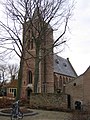
This is a category about rijksmonument number 37848
|
| Address |
|
Nederlands: Ritthem, Weverstraat 1 - Protestantse Kerk - anno 16e eeuw
Media in category "Protestantse Kerk (Ritthem)"
The following 25 files are in this category, out of 25 total.
-
 Exterieur - Ritthem - 20188700 - RCE.jpg 808 × 1,200; 224 KB
-
 Ingang toren - Ritthem - 20188696 - RCE.jpg 885 × 1,200; 247 KB
-
 Ingang toren - Ritthem - 20188697 - RCE.jpg 1,200 × 881; 233 KB
-
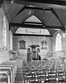 Interieur naar het oosten - Ritthem - 20188706 - RCE.jpg 957 × 1,200; 246 KB
-
 Interieur naar het westen - Ritthem - 20188707 - RCE.jpg 948 × 1,200; 226 KB
-
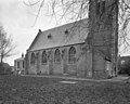
 Kerk van de restauratie vanuit het zuid-westen - Ritthem - 20188691 - RCE.jpg 897 × 1,200; 206 KB
-
 Kerk van de restauratie vanuit het zuid-westen - Ritthem - 20188692 - RCE.jpg 889 × 1,200; 248 KB
-
 Kerk vanuit het zuid-westen - Ritthem - 20188693 - RCE.jpg 880 × 1,200; 192 KB
-
 Kerk vanuit het zuiden - Ritthem - 20188694 - RCE.jpg 894 × 1,200; 245 KB
-
 Kerk vanuit het zuiden - Ritthem - 20188695 - RCE.jpg 887 × 1,200; 249 KB
-
 Kerk, exterieur - Ritthem - 20188698 - RCE.jpg 806 × 1,200; 221 KB
-
 Noordgevel - Ritthem - 20188704 - RCE.jpg 1,200 × 960; 337 KB
-
 Oostgevel - Ritthem - 20188705 - RCE.jpg 963 × 1,200; 340 KB
-
 Overzicht vanuit het zuid-westen - Ritthem - 20188702 - RCE.jpg 960 × 1,200; 330 KB
-
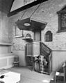 Preekstoel - Ritthem - 20188708 - RCE.jpg 955 × 1,200; 245 KB
-
 Protestantse Kerk (Ritthem)1.JPG 2,048 × 1,536; 1.28 MB
-
 Protestantse Kerk (Ritthem)2.JPG 1,536 × 2,048; 1.62 MB
-
 Protestantse Kerk (Ritthem)3.JPG 2,048 × 1,536; 1.55 MB
-
 Protestantse Kerk (Ritthem)4.JPG 1,723 × 1,500; 1,003 KB
-
 Protestantse Kerk (Ritthem)5.JPG 1,536 × 2,048; 1.59 MB
-
 Rittem.jpg 1,536 × 2,048; 1.2 MB
-

-
 Toren, exterieur - Ritthem - 20188699 - RCE.jpg 802 × 1,200; 211 KB
-
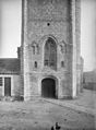
 Voorgevel - Ritthem - 20188712 - RCE.jpg 1,188 × 1,200; 323 KB
-
 Westzijde - Ritthem - 20188703 - RCE.jpg 960 × 1,200; 367 KB


2.JPG)
3.JPG)
4.JPG)
5.JPG)


