Category:Public transport maps of Baden-Württemberg
Federal states of Germany:
Urban districts (cities): Freiburg · Heidelberg · Heilbronn · Karlsruhe · Mannheim · Stuttgart · Ulm
Subcategories
This category has the following 10 subcategories, out of 10 total.
F
H
K
L
M
S
U
Media in category "Public transport maps of Baden-Württemberg"
The following 13 files are in this category, out of 13 total.
-
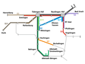
 20220221 LN S-Bahn RN 867x385 Mireo.png 3,413 × 1,515; 1.2 MB
-
 20230503 Liniennetzplan Planfall klein.png 960 × 720; 44 KB
-
 LokalbahnNetzentwicklungOppingen.png 3,080 × 2,331; 171 KB
-
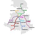
 Mögliches Streckennetz der Regionalstadtbahn Neckar Alb .jpg 1,159 × 1,243; 191 KB
-

-
 Regionalstadtbahn Neckar-Alb.jpg 4,475 × 3,474; 1.88 MB
-
 RVDI SBAHN.jpg 1,300 × 1,301; 342 KB
-
 Stadt-undStraßenbahnGleisplanHeidelberg2022.png 6,779 × 7,420; 1.08 MB
-
 Straßenbahn-undOBusNetzentwicklungBadenBaden.png 3,138 × 2,581; 296 KB
-
 Straßenbahn-undOBusNetzentwicklungPforzheim.png 7,936 × 3,996; 743 KB
-
 StraßenbahnNetzentwicklungRavensburg.png 1,607 × 2,415; 173 KB
-
 StraßenbahnNetzentwicklungReutlingen.png 2,718 × 4,307; 290 KB
-
 Streckenplan der Bahnstrecke Niederbiegen-Weingarten.png 1,017 × 850; 864 KB


