Category:Public transport maps of Shenzhen
Subcategories
This category has only the following subcategory.
R
Media in category "Public transport maps of Shenzhen"
The following 11 files are in this category, out of 11 total.
-
 Greater Bay Area Rail Transit Network.png 8,351 × 6,252; 4.61 MB
-
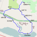 Happy Line route map.png 822 × 818; 166 KB
-
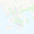 Hong Kong and Shenzhen public transport system map (with stations).png 10,859 × 10,735; 25.4 MB
-
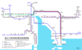
 Longhua Tram route map.png 1,222 × 1,567; 2.13 MB
-
 Map of Intercity Passenger Rail System in Pearl River Delta Area, China.png 6,602 × 4,017; 719 KB
-
 Map of the Rail Transport Infrastructure in the Pearl River Delta.png 6,805 × 8,218; 14.76 MB
-
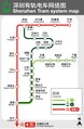 ShenzhenTramMap.pdf 1,770 × 2,708; 4.23 MB
-
 SZ 深圳 Shenzhen 龍華區 Longhua District 深圳有軌電車 Tram Feb-2018 IX1 04.jpg 2,048 × 1,368; 990 KB
-
 SZ 深圳 Shenzhen 龍華區 Longhua District 深圳有軌電車 Tram Feb-2018 IX1 167.jpg 2,048 × 1,368; 1.14 MB
-
 SZ 深圳 Shenzhen 龍華區 Longhua District 深圳有軌電車 Tram Feb-2018 IX1 48.jpg 2,048 × 1,368; 1.05 MB
-
 珠江三角洲地区城际轨道交通网示意图.png 2,020 × 2,195; 515 KB


.png)