Category:Punta Bagnà
| Object location | | View all coordinates using: OpenStreetMap |
|---|
mountain of the Cottian Alps  | |||||
| Upload media | |||||
| Instance of | |||||
|---|---|---|---|---|---|
| Part of | |||||
| Location | |||||
| Mountain range | |||||
| Topographic prominence |
| ||||
| Topographic isolation |
| ||||
| Elevation above sea level |
| ||||
| Parent peak | |||||
| Different from | |||||
 | |||||
Subcategories
This category has only the following subcategory.
P
- Panoramics from Punta Bagnà (1 F)
Media in category "Punta Bagnà"
The following 3 files are in this category, out of 3 total.
-
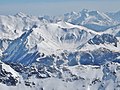 Panoramique Valfréjus.JPG 2,676 × 2,009; 1.84 MB
-
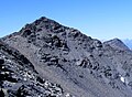
 Punta bagna terreno nerastro presso la cima.jpg 1,019 × 1,317; 364 KB
-
 Punta bagna versante nord est a dx punta del frejus.jpg 2,285 × 1,682; 679 KB

