Category:RAF Penrhos
| Object location | | View all coordinates using: OpenStreetMap |
|---|
former Royal Air Force airfield near Penrhos, Gwynedd | |||||
| Upload media | |||||
| Instance of |
| ||||
|---|---|---|---|---|---|
| Location | Wales | ||||
| Operator | |||||
| Inception |
| ||||
| Dissolved, abolished or demolished date |
| ||||
 | |||||
Media in category "RAF Penrhos"
The following 26 files are in this category, out of 26 total.
-

-
 A tiny corner of Wales forever Poland - geograph.org.uk - 619079.jpg 640 × 443; 122 KB
-

-
 Memorial at Penyberth - geograph.org.uk - 356855.jpg 640 × 428; 165 KB
-
 Pen-y-Berth caravan park - geograph.org.uk - 26173.jpg 640 × 480; 100 KB
-
 Polskie Osiedle Penrhos Polish Home - geograph.org.uk - 356831.jpg 640 × 428; 194 KB
-
 Polskie Osiedle Penrhos Polish Home - geograph.org.uk - 356837.jpg 640 × 428; 160 KB
-

-

-
 Royal Air Force 1939-1945- Bomber Command CH573.jpg 800 × 612; 67 KB
-

-

-
 The Mitre Hotel - geograph.org.uk - 664313.jpg 640 × 402; 55 KB
-
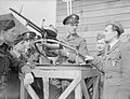
 The Polish Air Force in the United Kingdom, 1939-1945. CH589.jpg 2,404 × 1,772; 1,022 KB
-

-

-
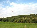 Windsock 2007 - geograph.org.uk - 615398.jpg 640 × 480; 61 KB
-

-

-
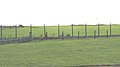
 Former RAF Penrhos - geograph.org.uk - 620174.jpg 640 × 480; 71 KB
-

-

-
 The concrete road to the Polish Village - geograph.org.uk - 619891.jpg 640 × 480; 160 KB
-
 The former RAF Penrhos - geograph.org.uk - 620495.jpg 640 × 360; 40 KB
-

-


.jpg)


