Category:Raamstraat 47, The Hague
| Object location | | View all coordinates using: OpenStreetMap |
|---|
building in The Hague, Netherlands  | |||||
| Upload media | |||||
| Instance of | |||||
|---|---|---|---|---|---|
| Location | The Hague, South Holland, Netherlands | ||||
| Street address |
| ||||
| Located on street | |||||
| Heritage designation |
| ||||
 | |||||
English: Raamstraat 47, The Hague, the Netherlands. From 1612 to 1620 this was the residence of Simon Stevin (1548 – 1620), a Flemish mathematician and military engineer.
Nederlands: Raamstraat 47, Den Haag, Nederland. Van 1612 tot 1620 was dit het woonhuis van Simon Stevin (1548 – 1620), een Vlaamse toegepast natuurkundige, wiskundige en ingenieur.
|
This is a category about rijksmonument number 17962
|
| Address |
|
Media in category "Raamstraat 47, The Hague"
The following 7 files are in this category, out of 7 total.
-
 Den Haag - Raamstraat 47.JPG 2,736 × 3,648; 4.26 MB
-
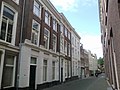
 Raamstraat , Den Haag, gezien richting Grote Marktstraat.jpg 2,592 × 1,944; 1.33 MB
-
 Raamstraat 47, Den Haag (photo 2).jpg 1,944 × 2,592; 1.25 MB
-
 Raamstraat 47, Den Haag (photo 3).jpg 1,944 × 2,592; 1.31 MB
-
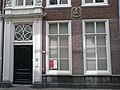 Raamstraat 47, Den Haag, gevel begane grond met entree.jpg 2,592 × 1,944; 1.29 MB
-
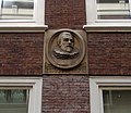 Raamstraat 47, Den Haag, gevelsteen Simon Stevin.jpg 2,236 × 1,944; 1.22 MB
-
 Raamstraat 47, Den Haag.jpg 2,592 × 1,944; 1.33 MB

.jpg)
.jpg)


