Category:Rail transport maps of Loiret
Media in category "Rail transport maps of Loiret"
The following 10 files are in this category, out of 10 total.
-
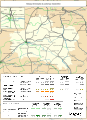
 Railway map of France - 45 - 1900 - fr - small.svg 705 × 968; 8.06 MB
-
 Railway map of France - 45 - 1913 - fr - small.svg 705 × 968; 8.24 MB
-
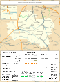
 Railway map of France - 45 - 1930 - fr - small.svg 705 × 968; 8.27 MB
-
 Railway map of France - 45 - 1950 - fr - small.svg 705 × 968; 8.19 MB
-
 Railway map of France - 45 - 1980 - fr - small.svg 705 × 968; 8.18 MB
-
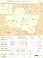
 Railway map of France - 45 - 2020 - fr - small.svg 705 × 968; 7.99 MB
-
 Railway map of France - 45 - animated - fr.gif 1,566 × 2,150; 5.77 MB
-
 Railway map of France - Orléans - animated - fr.gif 1,888 × 1,561; 12.9 MB
-
 VFIL Loiret 1928 (cropped).jpg 2,419 × 650; 282 KB
-
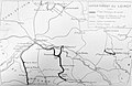 VFIL Loiret 1928.jpg 3,200 × 2,087; 1.48 MB


.jpg)