Category:Railroads on Cape Cod
Subcategories
This category has the following 12 subcategories, out of 12 total.
C
- Cape Cod Rail Trail (22 F)
- Cape Codder (NH train) (9 F)
M
O
- Old Colony Nature Pathway (3 F)
- Old Colony Rail Trail (5 F)
P
- Provincetown railroad wharf (4 F)
S
Media in category "Railroads on Cape Cod"
The following 18 files are in this category, out of 18 total.
-
 1865 West Barnstable to Woods Hole rail line map.jpg 10,760 × 3,959; 3.99 MB
-
 1868 Vineyard Sound Railroad profile map.jpg 10,315 × 4,044; 4.83 MB
-
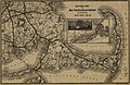
 1888 Old Colony Railroad Cape Cod map.png 3,500 × 2,436; 18.69 MB
-
 1893 Sectional Map of New York, New Haven and Hartford Railroad, Eastern District, Cape Cod.jpg 4,670 × 3,036; 17.25 MB
-
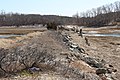 Cape Cod Railroad ROW in Truro (1), March 2014.jpg 5,184 × 3,456; 11.38 MB
-
 Cape Cod Railroad ROW in Truro (2), March 2014.jpg 5,184 × 3,456; 8.68 MB
-
 Cape Cod Railroad ROW in Truro (3), March 2014.jpg 5,184 × 3,456; 11.01 MB
-
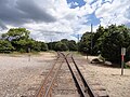 Cape Junction from canal side.jpg 4,608 × 3,456; 6.3 MB
-
 Cape Junction from land side.jpg 4,608 × 3,456; 5.84 MB
-
 Looking down the line towards Sagamore.JPG 4,608 × 3,456; 6.29 MB
-
 Old Colony Way, Hyannis, MA.JPG 4,320 × 3,240; 4.62 MB
-
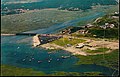 Pamet River 1960s aerial postcard.jpg 3,328 × 2,148; 2.24 MB
-
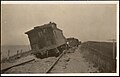 Postcard of derailment near Great Swamp, circa 1914.jpg 3,287 × 2,117; 552 KB
-
 Postcard of train approaching Woods Hole station.jpg 3,074 × 1,970; 2.2 MB
-
 Railroad switch in Bourne.JPG 4,608 × 3,456; 6.35 MB
-
 Splitting of the Woods Hole branch.JPG 4,608 × 3,456; 6.49 MB
-
 Town Neck Road Railroad Crossing, Sandwich, MA.jpg 2,592 × 1,936; 2.74 MB
-
 Truro railroad bridge 1968 postcard.jpg 3,324 × 2,127; 1.8 MB


,_March_2014.jpg)
,_March_2014.jpg)
,_March_2014.jpg)


