Category:Rapeseed fields in West Yorkshire
Media in category "Rapeseed fields in West Yorkshire"
The following 23 files are in this category, out of 23 total.
-
 A field of rape - geograph.org.uk - 2388590.jpg 2,209 × 1,296; 2.03 MB
-
 A Railway Cottage - geograph.org.uk - 397439.jpg 640 × 480; 87 KB
-

-
 A splash of colour - geograph.org.uk - 776485.jpg 640 × 480; 162 KB
-
 Bretton Lane - geograph.org.uk - 776483.jpg 640 × 480; 69 KB
-
 Bridleway to Intake Lane - geograph.org.uk - 415716.jpg 640 × 480; 92 KB
-
 Bridleway to Mollyhurst Lane - geograph.org.uk - 415192.jpg 640 × 480; 81 KB
-
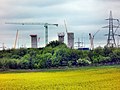 Building the new power station - geograph.org.uk - 3470334.jpg 3,820 × 2,865; 2.78 MB
-
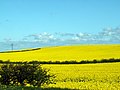
 Farm field of rape, Methley, Leeds - geograph.org.uk - 5479732.jpg 4,128 × 2,322; 3.34 MB
-
 Green to Yellow - geograph.org.uk - 776481.jpg 640 × 464; 109 KB
-
 Haw Top - geograph.org.uk - 404640.jpg 640 × 480; 77 KB
-
 Haw Top - geograph.org.uk - 404647.jpg 640 × 480; 78 KB
-
 Haw Top - geograph.org.uk - 415255.jpg 640 × 480; 56 KB
-
 Little Spring from Woodhouse Lane - geograph.org.uk - 417382.jpg 640 × 480; 84 KB
-
 Looking to Manor House Farm - geograph.org.uk - 758583.jpg 640 × 480; 71 KB
-
 Middle Field Lane - geograph.org.uk - 364036.jpg 640 × 480; 120 KB
-
 Notton - Notton Grange.jpg 640 × 426; 127 KB
-
 Oilseed rape field - geograph.org.uk - 493343.jpg 640 × 480; 127 KB
-

-
 Rapeseed in flower - geograph.org.uk - 2402527.jpg 1,024 × 768; 710 KB
-
 The M1 Motorway - geograph.org.uk - 397434.jpg 640 × 480; 96 KB
-
 Woolley Edge Lane - geograph.org.uk - 404635.jpg 640 × 480; 70 KB
-
 Woolley.jpg 640 × 480; 84 KB


