Category:Rauher Kopf (Paznaun)
mountain in the Paznaun in Tyrol  | |||||
| Upload media | |||||
| Instance of | |||||
|---|---|---|---|---|---|
| Location | Ischgl, Landeck District, Tyrol, Austria | ||||
| Mountain range | |||||
| Elevation above sea level |
| ||||
 | |||||
Media in category "Rauher Kopf (Paznaun)"
The following 9 files are in this category, out of 9 total.
-
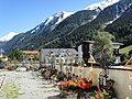 Friedhofmathon1.jpg 3,648 × 2,736; 4.23 MB
-
 Ischgl - Rauher Kopf - Scheune und Wanderweg.jpg 3,393 × 4,519; 10.93 MB
-
 Ischgl - Rauher Kopf 01.jpg 4,592 × 3,448; 12.34 MB
-
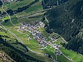 Mathon 01.jpg 4,592 × 3,448; 11.3 MB
-
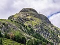
 Paznaun - Rauher Kopf - Gipfel 01.jpg 4,592 × 3,448; 10.98 MB
-
 Paznaun - Rauher Kopf - Gipfelkreuz - T-Shirt.jpg 4,592 × 3,448; 6.16 MB
-
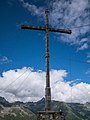 Paznaun - Rauher Kopf - Gipfelkreuz 01.jpg 3,448 × 4,592; 6.87 MB
-
 Paznaun - Rauher Kopf - Gipfelkreuz 02.jpg 3,448 × 4,592; 9.06 MB
-
 Paznaun - Rauher Kopf - Gipfelkreuz 03.jpg 3,255 × 4,335; 6.12 MB


