Category:Ravernet
village in County Down, Northern Ireland, UK | |||||
| Upload media | |||||
| Instance of | |||||
|---|---|---|---|---|---|
| Location | Northern Ireland | ||||
 | |||||
English: Ravernet is a small village and townland of 405 acres in the Electoral Division of Maze, in Civil Parish of Blaris (Iveagh portion), in the Barony of Iveagh Lower, Upper Half, in the County of Down, 3km south of Lisburn, and about the same distance north east of Hillsborough. It is to the south of the Ravernet River and close to the Sprucefield roundabout and the M1 motorway. In the 2001 Census it had a population of 559 people.
Media in category "Ravernet"
The following 24 files are in this category, out of 24 total.
-
 "Road narrows" sign, Lisburn - geograph.org.uk - 1749957.jpg 640 × 400; 104 KB
-
 Abandoned Cottage - geograph.org.uk - 93780.jpg 640 × 480; 99 KB
-
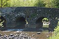 Bridge - geograph.org.uk - 441990.jpg 640 × 424; 69 KB
-
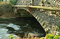 Bridge near Ravarnet - geograph.org.uk - 1144568.jpg 640 × 424; 105 KB
-
 Drumlin fields, Hillsborough (1) - geograph.org.uk - 2799999.jpg 640 × 358; 70 KB
-
 Fields and trees, Lisburn-Ravernet - geograph.org.uk - 3220176.jpg 640 × 437; 110 KB
-
 Gate, Ravernet near Lisburn - geograph.org.uk - 2965476.jpg 640 × 365; 117 KB
-
 Hawthorn blossom, Ravernet near Lisburn - geograph.org.uk - 2963993.jpg 613 × 328; 103 KB
-
 Letter box, Ravarnet near Lisburn - geograph.org.uk - 2488701.jpg 640 × 422; 151 KB
-
 Old building near Hillsborough - geograph.org.uk - 3275628.jpg 640 × 375; 74 KB
-
 The Legacurry Road - geograph.org.uk - 1764135.jpg 2,976 × 3,968; 4.93 MB
-
 The Ravernet Bridge near Lisburn - geograph.org.uk - 1764164.jpg 3,968 × 2,976; 4.98 MB
-
 The Ravernet Bridge near Lisburn - geograph.org.uk - 1764179.jpg 3,968 × 2,976; 4.77 MB
-
 The Ravernet Bridge near Lisburn - geograph.org.uk - 1764225.jpg 3,968 × 2,976; 5.17 MB
-

-
-
 The Ravernet River near Lisburn - geograph.org.uk - 1764211.jpg 3,968 × 2,976; 5.17 MB
-
 The Ravernet River near Ravernet - geograph.org.uk - 1764120.jpg 3,968 × 2,976; 5.08 MB
-

-
 Tullynore Mission Hall - geograph.org.uk - 93774.jpg 640 × 480; 86 KB
-
 Woodside Farm - geograph.org.uk - 93778.jpg 640 × 480; 101 KB
-
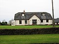 Chalet Bungalow - geograph.org.uk - 103179.jpg 640 × 480; 75 KB
-
 The Old Manse - geograph.org.uk - 103187.jpg 640 × 480; 108 KB
-
 Wooded valley west of Cabra Road - geograph.org.uk - 466738.jpg 640 × 480; 129 KB


_-_geograph.org.uk_-_2799999.jpg)


_-_geograph.org.uk_-_2964029.jpg)
_-_geograph.org.uk_-_2964048.jpg)


