Category:Reema Construction prefabricated halls
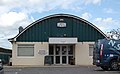
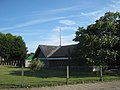
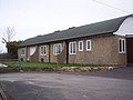
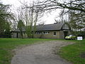
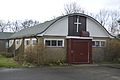
Reema Construction prefabricated halls are prefabricated buildings manufactured by Reema Construction, a subsidiary of Reed and Mallik Ltd of Salisbury, Wiltshire. The first was manufactured in 1954, and production continued into the 1970s. The halls have a distinctive barrel-vaulted roof supported by a timber arch, and walls made of Reema's proprietary precast concrete panels. The design was flexible, so various specifications and sizes were available, but the buildings could essentially be bought "off the shelf". Uses include churches, church halls, ambulance stations, village halls, Scout huts, community centres, sports pavilions and the like. Many have survived, although demolitions are becoming increasingly frequent in the 21st century.
Subcategories
This category has the following 27 subcategories, out of 27 total.
A
- Alderbury Village Hall (4 F)
- Apollo House, Andover (3 F)
B
- Baddesley Baptist Church (10 F)
- Broadstone War Memorial Hall (6 F)
F
G
- Great Shelford Memorial Hall (6 F)
L
- Lapworth Village Hall (5 F)
- Laverstock and Ford Village Hall (10 F)
M
- Mayfield Memorial Hall (2 F)
N
- New Milton Masonic Centre (4 F)
- Noor Mosque (5 F)
P
- Priory Hall, Andover (9 F)
S
V
- Verwood Memorial Hall (3 F)
W
- West Parley Memorial Hall (7 F)
- Wincanton War Memorial Hall (1 F)
Media in category "Reema Construction prefabricated halls"
The following 62 files are in this category, out of 62 total.
-
 All Saints Church Hall - geograph.org.uk - 3840091.jpg 640 × 399; 88 KB
-
 All Saints Church, Church Road, West Ewell (July 2013) (Parish Hall).JPG 2,400 × 1,800; 1.01 MB
-
 Blackwell Community Hall - geograph.org.uk - 237004.jpg 640 × 480; 62 KB
-
 Burnage Community Centre - geograph.org.uk - 5114726.jpg 1,000 × 750; 721 KB
-
 Chipstead Way, Woodmansterne - geograph.org.uk - 4092581.jpg 1,600 × 1,064; 406 KB
-

-
 Church Crookham, Hampshire - geograph.org.uk - 2247584.jpg 3,504 × 2,336; 493 KB
-
 Church Hall Woodmansterne - geograph.org.uk - 1342667.jpg 640 × 480; 97 KB
-

-
 Crookham War Memorial Hall - geograph.org.uk - 2887386.jpg 640 × 430; 106 KB
-

-
 Former Nissen Hut, Abbey Wood - geograph.org.uk - 2565582.jpg 4,288 × 3,216; 4.79 MB
-
 Funtley Social Club (Reema Construction Hall), Funtley Hill, Funtley (May 2019).JPG 2,600 × 1,600; 1.24 MB
-
 Funtley Social Club - geograph.org.uk - 1286077.jpg 640 × 427; 139 KB
-

-
 Gateway Church International, Southgate, Crawley 02.JPG 640 × 480; 141 KB
-
 Giggs Hill Church (2) - geograph.org.uk - 2527323.jpg 3,072 × 2,304; 2.06 MB
-
 Grimsby Baptist Church - geograph.org.uk - 324010.jpg 640 × 480; 89 KB
-
 Hall of All Saints with St Frideswyde, Thornton and Crosby.jpg 4,963 × 3,235; 18.01 MB
-
 Holy Cross Church - geograph.org.uk - 2791264.jpg 640 × 480; 571 KB
-

-
 Idmiston Memorial Hall - geograph.org.uk - 337827.jpg 640 × 480; 77 KB
-
 Little Fishes Day Nursery, Salisbury - geograph.org.uk - 4110993.jpg 800 × 685; 144 KB
-
 Lytham Road Youth Club.Brixton - geograph.org.uk - 2640622.jpg 4,288 × 3,216; 5.28 MB
-

-
 Memorial Hall, Stotfold - geograph.org.uk - 5725098.jpg 2,000 × 1,500; 677 KB
-
 Nork, Community Centre - geograph.org.uk - 4179985.jpg 4,320 × 3,240; 7.17 MB
-
 Norris Green Youth Centre - geograph.org.uk - 6138898.jpg 800 × 510; 64 KB
-
 Parish Hall of St Paul's Church, Warren Road, Nork (Reema Construction) (July 2013).JPG 2,500 × 1,500; 758 KB
-

-
 Petersfield Community Centre - geograph.org.uk - 357196.jpg 640 × 477; 85 KB
-

-

-
 Salisbury Scouts' Hall - Dennis Marsh House - geograph.org.uk - 4257749.jpg 2,304 × 1,704; 1.6 MB
-
 Sanderson Hall - geograph.org.uk - 6319920.jpg 800 × 600; 148 KB
-
 Sanderson Hall, St Pauls Cray - geograph.org.uk - 2527318.jpg 3,072 × 2,304; 1.91 MB
-

-
 Southbourne Village Hall - geograph.org.uk - 1024716.jpg 640 × 480; 69 KB
-
 St Andrew's Catholic church, Sandwich - geograph.org.uk - 1234544.jpg 640 × 480; 168 KB
-
 St Finbarr's Roman Catholic Church, Aylesham - geograph.org.uk - 2056645.jpg 3,072 × 2,304; 1.9 MB
-

-

-
 St Francis, Salisbury - church hall - geograph.org.uk - 5932560.jpg 1,024 × 768; 179 KB
-

-
 St John's Church Hall, Pretoria Road - geograph.org.uk - 5971057.jpg 1,024 × 684; 314 KB
-

-

-

-
 St Michael's Church Hall - geograph.org.uk - 3220175.jpg 4,288 × 3,216; 6.66 MB
-
 St Mildred's church hall, Lee - geograph.org.uk - 4237118.jpg 1,024 × 768; 241 KB
-
 St Saviour's Parish Church Hall - geograph.org.uk - 1709795.jpg 640 × 456; 118 KB
-

-
 St-marks-church-catford.jpg 6,016 × 4,000; 5.29 MB
-
 St. Finbarr's Roman Catholic Church, Aylesham (2) - geograph.org.uk - 2056649.jpg 3,072 × 2,304; 1.89 MB
-
 Stamford Free Church (Baptist) - geograph.org.uk - 6033395.jpg 3,776 × 2,520; 3.36 MB
-
 Tattenham Community Centre - geograph.org.uk - 20152.jpg 640 × 480; 95 KB
-

-

-
 West Thurrock Chapel - geograph.org.uk - 3223040.jpg 4,288 × 3,216; 6.4 MB
-
 Wigmore Free Church - geograph.org.uk - 1044542.jpg 640 × 481; 62 KB
-
 Wincanton Memorial Hall - geograph.org.uk - 475456.jpg 640 × 480; 89 KB
-
 Witchampton Village Hall - geograph.org.uk - 2800960.jpg 1,024 × 768; 157 KB

_(Parish_Hall).JPG)


,_New_Road,_East_Malling_(July_2012).JPG)

,_Funtley_Hill,_Funtley_(May_2019).JPG)

.JPG)

_-_geograph.org.uk_-_2527323.jpg)


_(July_2013).JPG)
,_Ramshill,_Petersfield_(July_2019).JPG)

_(Rear_Hall_-_Reema_Construction_Hall).JPG)
_(Church_Hall_-_Reema_Construction_Hall).JPG)


_(Church_Hall_-_Reema_Construction_Hall)_(1).JPG)
_(Church_Hall_-_Reema_Construction_Hall)_(2).JPG)

_(Church_Hall).JPG)

,_Pound_Road,_Pennington_(July_2021)_(1).JPG)
,_Pound_Road,_Pennington_(July_2021)_(2).JPG)
_(Church_Hall_-_Reema_Construction).JPG)


_-_geograph.org.uk_-_2056649.jpg)
_-_geograph.org.uk_-_6033395.jpg)


