Category:Reformierte Kirche (Dorf 11, Diemtigen)
| Object location | | View all coordinates using: OpenStreetMap |
|---|
church building in Diemtigen in the canton of Bern, Switzerland .jpg) | |||||
| Upload media | |||||
| Instance of | |||||
|---|---|---|---|---|---|
| Part of | |||||
| Location | Diemtigen, Frutigen-Niedersimmental administrative district, Oberland administrative region, Bern, Switzerland | ||||
| Street address |
| ||||
| Heritage designation |
| ||||
| Inception |
| ||||
 | |||||
Media in category "Reformierte Kirche (Dorf 11, Diemtigen)"
The following 4 files are in this category, out of 4 total.
-
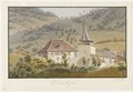 CH-NB - Diemtigen - Collection Gugelmann - GS-GUGE-WEIBEL-D-28a.tif 5,700 × 3,924, 2 pages; 39.67 MB
-
 CH-NB - Diemtigen - Collection Gugelmann - GS-GUGE-WEIBEL-D-28b.tif 5,700 × 3,781, 2 pages; 46.39 MB
-
 View from Ried towards Diemtigen (cropped).jpg 819 × 614; 331 KB
-
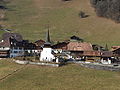 View from Ried towards Diemtigen.jpg 1,024 × 768; 518 KB
