Category:Rhode Island Avenue (Washington, D.C.)
English: Rhode Island Avenue is a diagonal avenue in the Northwest (Rhode Island Ave NW) and Northeast (Rhode Island Ave NE) quadrants of Washington, D.C., and the capital's inner suburbs in Prince George's County, Maryland. It was one of the original streets in Pierre L'Enfant's plan for the United States capital city.
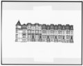
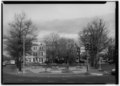
avenue in Washington, D.C.  The 1400 block of Rhode Island Ave NW in Washington, D.C.'s Logan Circle neighborhood | |||||
| Upload media | |||||
| Instance of | |||||
|---|---|---|---|---|---|
| Location |
| ||||
| Connects with | |||||
| Maintained by | |||||
| Terminus | |||||
| Partially coincident with | |||||
 | |||||
Subcategories
This category has the following 11 subcategories, out of 11 total.
A
- All Nations Baptist Church (5 F)
B
- Brodhead-Bell-Morton Mansion (8 F)
C
E
P
- Phyllis Wheatley YWCA (7 F)
S
Media in category "Rhode Island Avenue (Washington, D.C.)"
The following 67 files are in this category, out of 67 total.
-
-

-

-
 1301 Rhode Island Avenue – The Castle – red brick apartments 02.JPG 2,160 × 1,440; 789 KB
-

-

-

-
 1400 block of Rhode Island Avenue, N.W..jpg 2,454 × 2,102; 2.86 MB
-
 14th and Rhode Island Avenue, N.W..jpg 2,005 × 2,434; 2.82 MB
-
 1711 Rhode Island Avenue NW.jpg 3,368 × 2,451; 2.96 MB
-
 2000 block of Rhode Island Ave., NE, Washington, D.C LCCN2010641687.tif 5,368 × 3,080; 94.63 MB
-
 2000 block of Rhode Island Ave., NE, Washington, D.C LCCN2010641688.tif 2,212 × 2,684; 34 MB
-

-

-

-

-

-

-

-

-

-

-
 Asbury Dwellings (cropped).jpg 2,775 × 2,088; 1.83 MB
-
 Asbury Dwellings (cropped2).jpg 2,220 × 1,670; 1.35 MB
-
 Asbury Dwellings, Rhode Island Ave., Washington, D.C LCCN2010642239.tif 5,964 × 3,285; 112.13 MB
-
 Asbury Dwellings.jpg 3,033 × 2,088; 1.99 MB
-
 Capital Bikeshare Fall 2011 Expansion (6364935955).jpg 2,592 × 1,936; 2.01 MB
-
 Capital Bikeshare Summer 2013 Expansion (8889952688).jpg 1,632 × 1,224; 956 KB
-
 Carry On Club, 1600 R.I. Ave., 5-21-25 LCCN2016839882.jpg 5,270 × 4,227; 2.59 MB
-
 Carry On Club, 1600 R.I. Ave., 5-21-25 LCCN2016839882.tif 5,270 × 4,227; 21.25 MB
-

-
-

-

-
 Corner of Rhode Island Ave. and 16th St., NE, Washington, D.C LCCN2010641690.tif 4,818 × 3,651; 100.69 MB
-
 Corner of Rhode Island Ave. and 17th St., NE, Washington, D.C LCCN2010641689.tif 4,504 × 3,192; 82.3 MB
-
 Csisoffice.jpg 963 × 1,054; 286 KB
-

-
 DC Building.jpg 4,608 × 3,456; 5.57 MB
-

-
 Fire station, 5th St. near Rhode Island Ave. N.E., Washington, D.C LCCN2010641697.tif 6,114 × 3,800; 132.97 MB
-
 Frazier Funeral Home, founded 1917, 369 Rhode Island Ave., NW, Washington, D.C LCCN2010641962.tif 6,144 × 4,096; 144.03 MB
-
 Frazier Funeral Home, founded 1917, 369 Rhode Island Ave., NW, Washington, D.C LCCN2010641963.tif 6,144 × 3,792; 133.34 MB
-

-

-

-

-
 Looking N - North Capitol Street at Rhode Island Avenue - Washington DC.jpg 2,500 × 1,667; 3.39 MB
-
 Looking S - North Capitol Street at Rhode Island Avenue - Washington DC.jpg 2,500 × 1,667; 2.91 MB
-
 Metropolitan Branch Trail-13 (4576004884).jpg 3,552 × 2,368; 3.79 MB
-
 MG 1548 (8198742656).jpg 4,047 × 2,242; 5.42 MB
-
 MG 1981 (8260327852).jpg 4,694 × 2,245; 7.44 MB
-
 MG 4844 (8326652403).jpg 3,034 × 1,807; 3.26 MB
-

-
-
 Rhode Island Avenue Northwest, Washington, United States (Unsplash).jpg 3,067 × 2,045; 4.21 MB
-
 Rhode Island Avenue Shopping Center.jpg 598 × 402; 27 KB
-
 Sidewalk on Rhode Island Avenue.jpg 2,448 × 2,639; 3.05 MB
-
 SWB Rhode Island Avenue @ 12th Street NW; East of Logan Circle.jpg 3,648 × 2,736; 2.07 MB
-
 SWB US 29 @ 10th Street NW; Shaw, DC.jpg 3,648 × 2,736; 2.07 MB
-
 SWB US 29 @ 9th Street NW; Shaw, DC.jpg 3,648 × 2,736; 2.12 MB
-
 US Capital faint from Rhode Island Ave NW Overpass.jpg 3,735 × 2,801; 2.38 MB
-
 US Capital faint from Rhode Island Ave Overpass.jpg 4,395 × 3,296; 3.37 MB
-

-

-

-


_at_Eastern_Avenue,_crossing_into_Washington,_D.C._from_Mount_Rainier,_Prince_Georges_County,_Maryland.jpg)
_at_Otis_Street,_just_after_crossing_into_Washington,_D.C._from_Mount_Rainier,_Prince_Georges_County,_Maryland.jpg)
_at_16th_Place_NE_in_Washington,_D.C..jpg)
_at_V_Street_NE_in_Washington,_D.C..jpg)
_at_9th_Street_NW_in_Washington,_D.C..jpg)
.jpg)
.jpg)

.jpg)
.jpg)


_LCCN2016826779.jpg)


.jpg)
.jpg)
.jpg)
.jpg)
.jpg)


