Category:Rice Covered Bridge
| Object location | | View all coordinates using: OpenStreetMap |
|---|
Pennsylvania, on the National Register of Historic Places  | |||||
| Upload media | |||||
| Instance of | |||||
|---|---|---|---|---|---|
| Location | Pennsylvania | ||||
| Crosses |
| ||||
| Heritage designation |
| ||||
 | |||||
|
This is a category about a place or building that is listed on the National Register of Historic Places in the United States of America. Its reference number is 80003596. |
w:Rice Covered Bridge in w:Landisburg, PA, listed on the w:National Register of Historic Places.
Media in category "Rice Covered Bridge"
The following 8 files are in this category, out of 8 total.
-
 Rice Bridge Perry Co 1.JPG 2,570 × 1,927; 1.84 MB
-
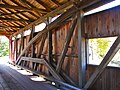 Rice Bridge Perry Co Interior.JPG 2,592 × 1,944; 2.13 MB
-
 Rice Covered Bridge (3003495365).jpg 1,024 × 768; 200 KB
-
 Rice Covered Bridge (3003495437).jpg 1,024 × 768; 154 KB
-
 Rice Covered Bridge (3004331750).jpg 1,024 × 768; 212 KB
-
 Rice Covered Bridge (3004331804).jpg 1,024 × 768; 121 KB
-
 Rice Covered Bridge (3004331980).jpg 1,024 × 768; 209 KB
-
 Rice Covered Bridge (3004332278).jpg 1,024 × 768; 229 KB

.jpg)
.jpg)
.jpg)
.jpg)
.jpg)
.jpg)