Category:Road F26 (Iceland)
Íslenska: Sprengisandsleið
Subcategories
This category has the following 3 subcategories, out of 3 total.
Media in category "Road F26 (Iceland)"
The following 15 files are in this category, out of 15 total.
-
 Iceland Route 26.png 1,131 × 402; 142 KB
-
 2014 Iceland Norðurland Eystra - Stafn banner.JPG 10,290 × 1,476; 7.82 MB
-
 2014-04-30 12-15-21 Iceland Norðurland Eystra - Akureyri.jpg 4,288 × 2,848; 7.8 MB
-
 2014-04-30 16-01-29 Iceland Norðurland Eystra - Stafn 9h 207°.JPG 23,485 × 2,564; 33.93 MB
-
 2014-04-30 16-03-28 Iceland Norðurland Eystra - Stafn.jpg 4,288 × 2,848; 6.98 MB
-
 Flowers along Route F26 - 2013.08 - panoramio.jpg 4,608 × 3,456; 3.34 MB
-
 Highland Route F26 - 2013.08 - panoramio (1).jpg 4,555 × 3,416; 4.4 MB
-
 Highland Route F26 - 2013.08 - panoramio.jpg 4,608 × 3,456; 4.43 MB
-
 Iceland Route F26.png 660 × 835; 85 KB
-
 ISL F26.svg 800 × 400; 9 KB
-
 Islande Sprengisandur désert piste.jpg 1,536 × 1,024; 503 KB
-
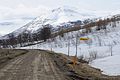
 Road F26, on the way to F225. - panoramio.jpg 2,048 × 1,360; 785 KB
-
 Route F26 along River Skjálfandafljót - 2013.08 - panoramio.jpg 4,555 × 3,416; 5.18 MB
-
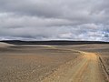 Route F26 through the Sprengisandur Area - 2013.08 - panoramio.jpg 4,544 × 3,408; 4.87 MB
-
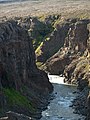 Ytra-Fljótsgil (3861824868).jpg 1,920 × 2,560; 1.83 MB


.jpg)


.jpg)