Category:Road maps of U.S. Highways in New York (state)
States of the United States: Alabama · Arizona · Colorado · Connecticut · Florida · Georgia · Idaho · Illinois · Indiana · Iowa · Kansas · Louisiana · Maine · Maryland · Michigan · Nevada · New Jersey · New Mexico · New York · North Carolina · Ohio · Pennsylvania · South Carolina · Texas · Utah · Virginia · Wisconsin · Wyoming
Media in category "Road maps of U.S. Highways in New York (state)"
The following 18 files are in this category, out of 18 total.
-
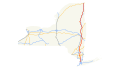
 US 1 (NY) map.svg 1,180 × 688; 460 KB
-
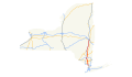
 US 4 (NY) map.svg 1,180 × 688; 420 KB
-
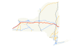
 US 6 (NY) map.svg 1,180 × 688; 421 KB
-
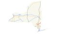
 US 9 (NY) map.png 2,255 × 1,333; 161 KB
-
 US 9 (NY) map.svg 1,180 × 688; 427 KB
-
 US 9W (NY) map.svg 1,180 × 688; 422 KB
-
 US 11 (NY) map.svg 1,180 × 688; 426 KB
-
 US 15 (NY) map.svg 1,180 × 688; 418 KB
-
 US 20 (NY) map.svg 1,180 × 688; 426 KB
-
 US 20A (NY) map.png 2,205 × 1,286; 62 KB
-
 US 20A (NY) map.svg 1,180 × 688; 419 KB
-
 US 44 (NY) map.svg 1,180 × 688; 419 KB
-
 US 62 (NY) map.svg 1,180 × 688; 419 KB
-
 US 62 Bus Niagara Falls NY map.svg 2,283 × 1,354; 1.12 MB
-
 US 202 (NY) map.svg 1,180 × 688; 420 KB
-
 US 209 (NY) map.svg 1,180 × 688; 419 KB
-
 U.S. Route 219 in New York map.png 933 × 610; 80 KB
-
 US 219 (NY) map.svg 1,180 × 688; 419 KB
_map.svg)
_map.svg)
_map.svg)
_map.png)
_map.svg)
_map.svg)
_map.svg)
_map.svg)
_map.svg)
_map.png)
_map.svg)
_map.svg)
_map.svg)

_map.svg)
_map.svg)

_map.svg)