Category:Roc de Sers
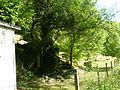
English: Prehistoric cave at "Le Roc", Sers, Charente, SW France
| Object location | | View all coordinates using: OpenStreetMap |
|---|
|
This building is classé au titre des monuments historiques de la France. It is indexed in the base Mérimée, a database of architectural heritage maintained by the French Ministry of Culture, under the reference PA00104515
|
cave in France  | |||||
| Upload media | |||||
| Instance of |
| ||||
|---|---|---|---|---|---|
| Location | Sers, canton of Villebois-Lavalette | ||||
| Street address |
| ||||
| Heritage designation |
| ||||
 | |||||
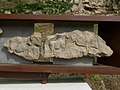
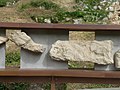
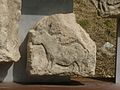
Media in category "Roc de Sers"
The following 28 files are in this category, out of 28 total.
-
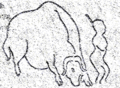 Roc-de-Sers (Charente).png 544 × 398; 26 KB
-
 Roc-de-Sers 01.jpg 4,288 × 2,848; 1.35 MB
-
 Roc-de-Sers 02.jpg 4,288 × 2,848; 2.44 MB
-
 Roc-de-Sers 05.jpg 4,288 × 2,848; 2.07 MB
-
 Roc-de-Sers 06.jpg 4,288 × 2,848; 1.72 MB
-
 Roc-de-Sers 07.jpg 4,288 × 2,848; 1.83 MB
-
 Roc-de-Sers 12-homme.jpg 518 × 780; 136 KB
-
 Roc-de-Sers 12.jpg 4,288 × 2,848; 1.76 MB
-
 Roc-de-Sers 15 homme.jpg 783 × 1,179; 241 KB
-
 Roc-de-Sers 15.jpg 4,288 × 2,848; 1.72 MB
-
 Roc-de-Sers 16.jpg 4,288 × 2,848; 1.75 MB
-
 Roc-de-Sers 21.jpg 4,288 × 2,848; 1.75 MB
-
 Roc-de-Sers 22.jpg 4,288 × 2,848; 1.63 MB
-
 Roc-de-Sers 24.jpg 4,288 × 2,848; 2.14 MB
-
 Roc-de-Sers 25.jpg 4,288 × 2,848; 1.91 MB
-
 Sersroc frise 1,2.JPG 1,600 × 1,200; 422 KB
-
 Sersroc frise 10,11.JPG 1,600 × 1,200; 446 KB
-
 Sersroc frise 3,4.JPG 1,600 × 1,200; 400 KB
-
 Sersroc frise 5,6.JPG 1,600 × 1,200; 432 KB
-
 Sersroc frise 6,7.JPG 1,600 × 1,200; 497 KB
-
 Sersroc frise 8,9.JPG 1,600 × 1,200; 405 KB
-
 Sersroc frise 8.JPG 1,600 × 1,200; 478 KB
-
 Sersroc frise.JPG 1,600 × 1,200; 699 KB
-
 Sersroc1.JPG 1,600 × 1,200; 562 KB
-
 Sersroc2.JPG 1,600 × 1,200; 813 KB
-
 Sersroc3.JPG 1,600 × 1,200; 682 KB
-
 Sersroc4.JPG 1,600 × 1,200; 765 KB
-
 Sersroc5.JPG 1,600 × 1,200; 583 KB
.png)


