Category:Rock Lane West bridge
| Object location | | View all coordinates using: OpenStreetMap |
|---|
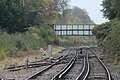
This bridge carries Rock Lane West over the Wirral Line. It is designated CRR2/50 on the Hooton Junction to Rock Ferry branch (CRR2) of the Chester & Rock Ferry Line and is 13.17 miles from the datum at Chester.
Media in category "Rock Lane West bridge"
The following 5 files are in this category, out of 5 total.
-
 Rock Lane West bridge 1.jpg 5,007 × 3,267; 11.35 MB
-
 Rock Lane West bridge 2.jpg 5,148 × 3,432; 12.57 MB
-
 Rock Lane West bridge from Rock Ferry station.jpg 5,138 × 3,426; 12.9 MB
-
 Rock Lane West bridge from Rocklands bridge, Bebington.jpg 5,130 × 3,420; 18.36 MB
-
 View north from Rock Lane West bridge.jpg 4,336 × 2,891; 8.29 MB


